「ムーレ・オ・ロムスダール県」の版間の差分
削除された内容 追加された内容
画像、他国語版リンク追加 |
Vina-iwbot~jawiki (会話 | 投稿記録) m ロボットによる 追加: zh:默勒-鲁姆斯达尔郡 |
||
| 88行目: | 88行目: | ||
[[Category:ノルウェーの県]] |
[[Category:ノルウェーの県]] |
||
| ⚫ | |||
[[ca:Møre og Romsdal]] |
[[ca:Møre og Romsdal]] |
||
[[cs:Møre og Romsdal]] |
[[cs:Møre og Romsdal]] |
||
| 93行目: | 94行目: | ||
[[de:Møre og Romsdal]] |
[[de:Møre og Romsdal]] |
||
[[en:Møre og Romsdal]] |
[[en:Møre og Romsdal]] |
||
| ⚫ | |||
| ⚫ | |||
[[eo:Møre og Romsdal]] |
[[eo:Møre og Romsdal]] |
||
| ⚫ | |||
| ⚫ | |||
| ⚫ | |||
[[fr:Comté de Møre og Romsdal]] |
[[fr:Comté de Møre og Romsdal]] |
||
| ⚫ | |||
[[id:Møre og Romsdal]] |
[[id:Møre og Romsdal]] |
||
| ⚫ | |||
[[is:Mæri og Raumsdalur]] |
[[is:Mæri og Raumsdalur]] |
||
| ⚫ | |||
[[kw:Møre og Romsdal]] |
[[kw:Møre og Romsdal]] |
||
[[na:Møre og Romsdal]] |
[[na:Møre og Romsdal]] |
||
| ⚫ | |||
[[nl:Møre og Romsdal]] |
[[nl:Møre og Romsdal]] |
||
| ⚫ | |||
[[nn:Møre og Romsdal fylke]] |
[[nn:Møre og Romsdal fylke]] |
||
[[ |
[[no:Møre og Romsdal]] |
||
[[pl:Møre og Romsdal]] |
[[pl:Møre og Romsdal]] |
||
[[pt:Møre og Romsdal]] |
[[pt:Møre og Romsdal]] |
||
| 114行目: | 115行目: | ||
[[sl:Møre og Romsdal]] |
[[sl:Møre og Romsdal]] |
||
[[sr:Мере ог Румсдал]] |
[[sr:Мере ог Румсдал]] |
||
| ⚫ | |||
[[sv:Møre og Romsdal fylke]] |
[[sv:Møre og Romsdal fylke]] |
||
[[tr:Møre og Romsdal]] |
[[tr:Møre og Romsdal]] |
||
[[zh:默勒-鲁姆斯达尔郡]] |
|||
2008年4月29日 (火) 14:12時点における版
- ムーレ・オ・ロムスダール県
- Møre og Romsdal fylke
-
ムーレ・オ・ロムスダール県の県章 県の紋章 - ムーレ・オ・ロムスダール県の位置
-
国  ノルウェー王国
地方区分 ヴェストラン(Vestlandet) 県庁所在地 モルデ 公用語 ノルウェー語 面積
- 総計
- 陸上
- 水域
- 国土に占める割合11位
15,121 km2
km2
km2 (%)
- 4.79 %人口
- 総計 (2004)
- 全人口に占める割合
- 人口変化 (10年)
- 人口密度7位
244,570 人
5.34 %
2.0 %
17 人/km2県内総生産
- 総計(2001)
- 全GDPに占める割合6位
593億5200万 万NOK
3.89 %県番号 {{{県番号}}} ISO 3166-2:NO NO-15 時間帯(夏時間) CET (UTC+1)
CEST (UTC+2)
ムーレ・オ・ロムスダール県(Møre og Romsdal)はノルウェーの県。ヴェストラン地方の最北部にある県。東にソール・トロンデラーグ県、南にオップラン県、西にソグン・オ・フィヨーラネ県、北にノルウェー海と接している。県庁所在地はモルデ。ロムスダール県として一般的に知られている。
名称・県章
ムーレ・オ・ロムスダールの名前は1936年に作られた。ムーレはノールムーレとサンムーレの両地域を表し、ロムスダールはロムスダール地域を表している。 1919年まではこの県はロムスダール県と呼ばれており、1919から1935まではムーレ県と呼ばれていた。
県章は1978年に決められたもので、3つのマークはそれぞれバイキングの船を表しておりマストが十字を表す。 3つのマークがそれぞれサンムーレ、ロムスダール、ノールムーレの三地域を表す。
地域

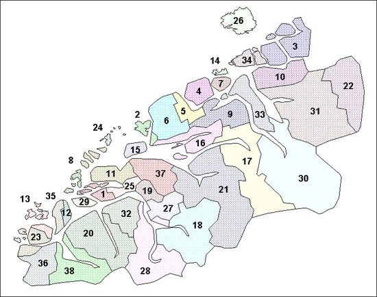
この県は慣習的に3つの地域に分けられる。 ノールムーレ、ロムスダール、サンムーレがそれぞれ北部、中部、南部となっている。 商業的、文化的な関係にもかかわらず、地域の間には敵対的な関係がある。 歴史的に、ノールムーレはソール・トロンデラーグ県と関係が強く、ロムスダールはオップラン県、サンムーレはソグン・オ・フィヨーラネ県との関係が深い。 地域間の方言の違いがこれを如実に表している。 地理的特徴ゆえ、この県は人口の多い島を多く持っており、いくつかの深いフィヨルドがある。海上交通に依存しており、その多くがカーフェリーの会社である。MRF社は1921年から存在している。
|
|
|
