岸 (地形)


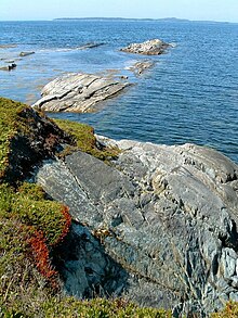
岸(きし、英語: shore)とは、大洋、海、湖などの大きな水域の端で陸地と接する地形のことである。海洋物理学では、岸は過去から現在までの水域の作用によって地質学的に変化した広い端であり、浜は海岸の端にあって潮間帯を表している[1]。海の岸を海岸、湖の岸を湖岸(こがん)、川の岸を河岸(かがん)のように言う。
岸は、波のような水の浸食と同様、周囲の地形によって影響を受ける[2]。岩石と土壌の地質学的組成は、それが作られた岸の類型を決定する。
名称[編集]
英語[編集]
英語では、coast(沿岸・海岸)とは対照的に、shore(岸)はあらゆる水域に接することができるが、coastは海に接していなければならない。しかし、coast は shore よりもはるかに広い地域を指すことが多く、多くの場合、何マイルにもわたって内陸まで伸びている。
イタリア語[編集]
Rivierasはイタリア語で「海岸線」を意味する言葉で[3][4]、結局のところラテン語のripa(川岸)に由来する。リグーリア海岸の正式名称としてriviera ligureと呼ばれ、それからRiviera(リヴィエラ)に短縮された。歴史的にはリグーリアのリヴィエラはジェノヴァの南にあるカーポ・コルヴォ(プンタ・ビアンカ)から北と西に伸び、現在のフランス領である昔のモナコを越え、時にはマルセイユまで続いていた[5][6]。現在はイタリアのリヴィエラとフランスのリヴィエラに分かれているが、フランス人はイタリア側を指すために「リヴィエラ」という言葉を使い、フランスの部分を「コート・ダジュール」と呼んでいる。
リグーリアのリヴィエラが有名になった結果、この言葉は英語になって、特に日当たりが良く、地形的に多様性があり、観光客に人気のある海岸線を指すようになった。この言葉を使っている場所には、クイーンズランド州のオーストラリアのリヴィエラやエーゲ海沿いのトルコのリヴィエラなどがある[3]。
脚注[編集]
出典[編集]
- ^ Pickard, George L.; William J. Emery (1990). Descriptive Physical Oceanography (5, illustrated ed.). Elsevier. pp. 7–8. ISBN 075062759X
- ^ “海岸 > 渚にまつわるetc > 用語集”. 茨城県. 茨城県. 2020年5月7日閲覧。
- ^ a b Kolb, Martina (2013). Nietzsche, Freud, Benn, and the Azure Spell of Liguria. Toronto, Ontario: University of Toronto Press. p. 30. ISBN 978-1-4426-4329-1
- ^ The more common ones are puntellare and litorale.
- ^ Baughan, Rosa (1880). Winter havens in the sunny South, a complete handbook to the Riviera. London: The Bazaar. オリジナルの2017-02-02時点におけるアーカイブ。
- ^ Black, Charles B. (1887). The Riviera, Or The Coast from Marseilles to Leghorn, Including Carrara, Lucca, Pisa, Pistoja and Florence (Third ed.). Edinburgh: Adam and Charles Black. オリジナルの2017-02-02時点におけるアーカイブ。
参考文献[編集]
- Anders, F.J., and Byrnes, M.R. (1991) Accuracy of shoreline change rates as determined from maps and aerial photographs Shore and Beach, v. 59, no. 1, pp. 17–26.
- Anthony, Edward J. (2008) Shore Processes and their Palaeoenvironmental Applications Elsevier, Amsterdam, ISBN 978-0-08-055886-8
- Boaden, Patrick J. S. and Seed, Raymond (1985) An Introduction to Coastal Ecology Blackie, Glasgow, ISBN 978-0-412-01021-7
- Bothner, M.H., and Butman, Bradford. (2007) Processes influencing the transport and fate of contaminated sediments in the coastal ocean—Boston Harbor and Massachusetts Bay, U.S. Geological Survey Circular 1302, pp. 1–89.
- Dean, R.G. (1991) Equilibrium beach profiles—characteristics and applications Journal of Coastal Research, v. 7, no. 1, pp. 53–84.
- Komar, P.D. (1996) The Budget of Littoral Sediments—Concepts and Applications Shore and Beach, v. 64, pp. 18–26.
- Meade, Robert H. (1982). “Sources, Sinks, and Storage of River Sediment in the Atlantic Drainage of the United States”. The Journal of Geology 90 (3): 235–252. doi:10.1086/628677.
- Stauble, D.K. and Brumbaugh, R.W. (2003) An Assessment of the Nation's Shorelines, USA Shore and Beach v. 71, no. 3, pp. 11–18.
- Stockdon, H.F., Sallenger, A.H., List, J.H., and Holman, R.A. (2002) Estimation of shoreline position and change using airborne topographic lidar data Journal of Coastal Research, v. 18, no. 3, pp. 502–513.
- Thieler, E.R., Pilkey, O.H., Young, R.S., Bush, D.M., and Chai, F. (2000) The use of mathematical models to predict beach behavior for U.S. coastal engineering—A critical review Journal of Coastal Research, v. 16, no. 1, pp. 48–70.
