
ファイル:Mugello Racing Circuit track map.svg

この SVG ファイルのこの PNG プレビューのサイズ: 800 × 501 ピクセル. その他の解像度: 320 × 200 ピクセル | 640 × 401 ピクセル | 1,024 × 641 ピクセル | 1,280 × 801 ピクセル | 2,560 × 1,603 ピクセル | 1,391 × 871 ピクセル。
元のファイル (SVG ファイル、1,391 × 871 ピクセル、ファイルサイズ: 64キロバイト)
ウィキメディア・コモンズのファイルページにある説明を、以下に表示します。
|
概要
| 解説 |
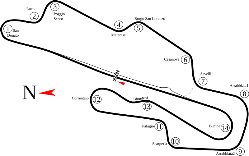
English: Track map of Mugello Circuit in Italy. The gray dashed line represents pavement that has the same width as the main track, but only leads to pit road. Because of its location, the author of this image believes that it is only used by cars needing a shorter route back to the paddock. |
| 日付 | 8-5-2008 |
| 原典 | 投稿者自身による著作物 |
| 作者 | Will Pittenger |
| その他のバージョン |
|
.png)
| カメラの位置 | | 以下のサービスでこの位置を確認する: オープンストリートマップ |
|---|
ライセンス
この作品の著作権者である私は、この作品を以下のライセンスで提供します。
このファイルはクリエイティブ・コモンズ 表示-継承 3.0 非移植ライセンスのもとに利用を許諾されています。
- あなたは以下の条件に従う場合に限り、自由に
- 共有 – 本作品を複製、頒布、展示、実演できます。
- 再構成 – 二次的著作物を作成できます。
- あなたの従うべき条件は以下の通りです。
- 表示 – あなたは適切なクレジットを表示し、ライセンスへのリンクを提供し、変更があったらその旨を示さなければなりません。これらは合理的であればどのような方法で行っても構いませんが、許諾者があなたやあなたの利用行為を支持していると示唆するような方法は除きます。
- 継承 – もしあなたがこの作品をリミックスしたり、改変したり、加工した場合には、あなたはあなたの貢献部分を元の作品とこれと同一または互換性があるライセンスの下に頒布しなければなりません。
ファイルの履歴
過去の版のファイルを表示するには、その版の日時をクリックしてください。
| 日付と時刻 | サムネイル | 寸法 | 利用者 | コメント | |
|---|---|---|---|---|---|
| 現在の版 | 2010年7月4日 (日) 22:23 | | 1,391 × 871 (64キロバイト) | Restu20 | correct some name |
| 2008年8月5日 (火) 09:16 |  | 1,391 × 871 (64キロバイト) | Will Pittenger | New version fixes the vertical black bar that shouldn't have been there. (It was actually an unneeded flowed text box that got in somehow.) | |
| 2008年8月5日 (火) 08:54 |  | 1,391 × 871 (64キロバイト) | Will Pittenger | New version has the turn numbers grouped to matching turn names | |
| 2008年8月5日 (火) 08:45 |  | 1,391 × 871 (63キロバイト) | Will Pittenger | New version has larger North Arrow and Start/Finish line | |
| 2008年8月5日 (火) 08:32 |  | 1,391 × 871 (62キロバイト) | Will Pittenger | {{Information |Description={{en|1=Track map of w:Mugello Circuit in Italy. The gray dashed line represents pavement that has the same width as the main track, but only leads to pit road. Because of its location, the author of this image believes th |
ファイルの使用状況
以下の 16 ページがこのファイルを使用しています:
- 2004年のイタリアグランプリ (ロードレース)
- 2005年のイタリアグランプリ (ロードレース)
- 2006年のイタリアグランプリ (ロードレース)
- 2007年のイタリアグランプリ (ロードレース)
- 2008年のイタリアグランプリ (ロードレース)
- 2009年のイタリアグランプリ (ロードレース)
- 2010年のイタリアグランプリ (ロードレース)
- 2011年のイタリアグランプリ (ロードレース)
- 2020年トスカーナグランプリ
- 2021年のイタリアグランプリ (ロードレース)
- 2022年のイタリアグランプリ (ロードレース)
- 2023年のイタリアグランプリ (ロードレース)
- イタリアグランプリ
- イタリアグランプリ (ロードレース)
- サンマリノグランプリ (ロードレース)
- ムジェロ・サーキット
グローバルなファイル使用状況
以下に挙げる他のウィキがこの画像を使っています:
- ar.wikipedia.org での使用状況
- جائزة إيطاليا الكبرى للدراجات النارية 2006
- حلبة موجيلو
- جائزة إيطاليا الكبرى للدراجات النارية 2004
- جائزة إيطاليا الكبرى للدراجات النارية 2005
- جائزة إيطاليا الكبرى للدراجات النارية 2007
- جائزة إيطاليا الكبرى للدراجات النارية 2008
- جائزة إيطاليا الكبرى للدراجات النارية 2009
- جائزة إيطاليا الكبرى للدراجات النارية 2010
- جائزة إيطاليا الكبرى للدراجات النارية 2011
- جائزة إيطاليا الكبرى للدراجات النارية 2012
- جائزة إيطاليا الكبرى للدراجات النارية 2013
- جائزة إيطاليا الكبرى للدراجات النارية 2014
- جائزة إيطاليا الكبرى للدراجات النارية 2015
- جائزة إيطاليا الكبرى للدراجات النارية 1992
- جائزة إيطاليا الكبرى للدراجات النارية 1994
- جائزة إيطاليا الكبرى للدراجات النارية 1995
- جائزة إيطاليا الكبرى للدراجات النارية 1996
- جائزة إيطاليا الكبرى للدراجات النارية 1997
- جائزة إيطاليا الكبرى للدراجات النارية 1998
- جائزة إيطاليا الكبرى للدراجات النارية 1999
- جائزة إيطاليا الكبرى للدراجات النارية 2000
- جائزة سان مارينو الكبرى للدراجات النارية 1991
- جائزة سان مارينو الكبرى للدراجات النارية 1993
- جائزة الأمم الكبرى للدراجات النارية 1978
- جائزة الأمم الكبرى للدراجات النارية 1976
- جائزة إيطاليا الكبرى للدراجات النارية 2018
- جائزة إيطاليا الكبرى للدراجات النارية 2019
- ast.wikipedia.org での使用状況
- ca.wikipedia.org での使用状況
- cs.wikipedia.org での使用状況
- de.wikipedia.org での使用状況
- en.wikipedia.org での使用状況
- es.wikipedia.org での使用状況
- Anexo:Grandes Premios de Fórmula 1
- Anexo:Circuitos de Fórmula 1
- Autódromo Internacional del Mugello
- Gran Premio de Italia de Motociclismo
- Temporada 2012 de Fórmula 1
- Anexo:Pretemporada 2012 de Fórmula 1
- Temporada 2014 de MotoGP
- Gran Premio de Italia de Motociclismo de 2012
- Gran Premio de Italia de Motociclismo de 2013
- Gran Premio de Italia de Motociclismo de 2014
- Gran Premio de Italia de Motociclismo de 2015
このファイルのグローバル使用状況を表示する。