ビューニンゲン
ビューニンゲン | |||
|---|---|---|---|
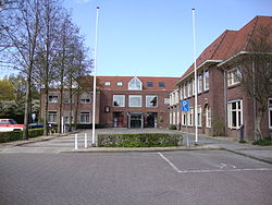
 Beuningen town hall | |||
| |||
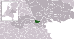
 Location in Gelderland | |||
| 北緯51度52分 東経5度47分 / 北緯51.867度 東経5.783度座標: 北緯51度52分 東経5度47分 / 北緯51.867度 東経5.783度 | |||
| 国 |
| ||
| 州 | ヘルダーラント州 | ||
| 政府 | |||
| • 議会 | 議会 | ||
| • 市長 | Carol van Eert (労働党) | ||
| 面積 | |||
| • 合計 | 47.09 km2 | ||
| • 陸地 | 43.70 km2 | ||
| • 水域 | 3.39 km2 | ||
| 標高 | 9 m | ||
| 人口 (2014年5月)[4] | |||
| • 合計 | 25,267人 | ||
| • 密度 | 578人/km2 | ||
| 族称 | Beuninger | ||
| 等時帯 | UTC+1 (CET) | ||
| • 夏時間 | UTC+2 (CEST) | ||
| 郵便番号 |
6550–6551, 6640–6645 | ||
| 市外局番 | 024, 0487 | ||
| ウェブサイト |
www | ||
ビューニンゲン、ブーニンゲン(オランダ語: Beuningen [ˈbøːnɪŋə(n)] (![]() 音声ファイル))とは、オランダヘルダーラント州にある基礎自治体(ヘメーンテ)。
音声ファイル))とは、オランダヘルダーラント州にある基礎自治体(ヘメーンテ)。
概要[編集]
ナイメーヘンの西に位置するヘメーンテで、ワール川の南岸に位置している。
A73とA50のジャンクシャンが存在している他、再建された風車が存在している。
集落[編集]


参考文献[編集]
- ^ “Carol van Eert” (Dutch). Gemeente Beuningen. 2014年6月19日時点のオリジナルよりアーカイブ。2014年6月19日閲覧。
- ^ “Kerncijfers wijken en buurten”. CBS Stadline. 2014年3月12日閲覧。
- ^ “Postcodetool for 6641AE” (Dutch). Actueel Hoogtebestand Nederland. Het Waterschapshuis. 2014年6月19日閲覧。
- ^ “Bevolkingsontwikkeling; regio per maand”. CBS Stadline. 2014年7月24日閲覧。
外部リンク[編集]
 ウィキメディア・コモンズには、ビューニンゲンに関するカテゴリがあります。
- Official website

|
ネーデル=ベートゥヴェ ワール川 |
オーファーベートゥヴェ ワール川 |

| |
| ドゥルーテン | ナイメーヘン | |||
| ヴィヘン |

