
「フィティン山」の版間の差分
削除された内容 追加された内容
m →top |
en:Khüiten Peak 2019-08-13T13:53:46版を元に追記 |
||
| 15行目: | 15行目: | ||
| listing = [[国別の最高地点一覧|モンゴル最高峰]]<br />[[ウルトラ・プロミネント峰]] |
| listing = [[国別の最高地点一覧|モンゴル最高峰]]<br />[[ウルトラ・プロミネント峰]] |
||
| location = {{flag|Mongolia}}<br />{{CHN}} |
| location = {{flag|Mongolia}}<br />{{CHN}} |
||
| range = タ |
| range = [[タワン・ボグド]]連山<br />[[アルタイ山脈]] |
||
| coordinates = {{coord2|49|8|45|N|87|49|8|E|type:mountain_scale:100000|format=dms|display=inline,title}} |
| coordinates = {{coord2|49|8|45|N|87|49|8|E|type:mountain_scale:100000|format=dms|display=inline,title}} |
||
| coordinates_ref = <ref>[http://maps.google.com/ Google Maps]</ref> |
| coordinates_ref = <ref>[http://maps.google.com/ Google Maps]</ref> |
||
| 23行目: | 23行目: | ||
| volcanic_arc/belt = |
| volcanic_arc/belt = |
||
| last_eruption = |
| last_eruption = |
||
| first_ascent = |
| first_ascent = 1963年 モンゴル隊 |
||
| easiest_route = |
| easiest_route = |
||
}} |
}} |
||
{{中華圏の事物 |
|||
| ⚫ | |||
|繁体字=友誼峰 |
|||
|簡体字=友谊峰 |
|||
|ピン音=Yǒuyì Fēng |
|||
|日本語=ゆうぎほう |
|||
|英文=Khüiten Peak |
|||
}} |
|||
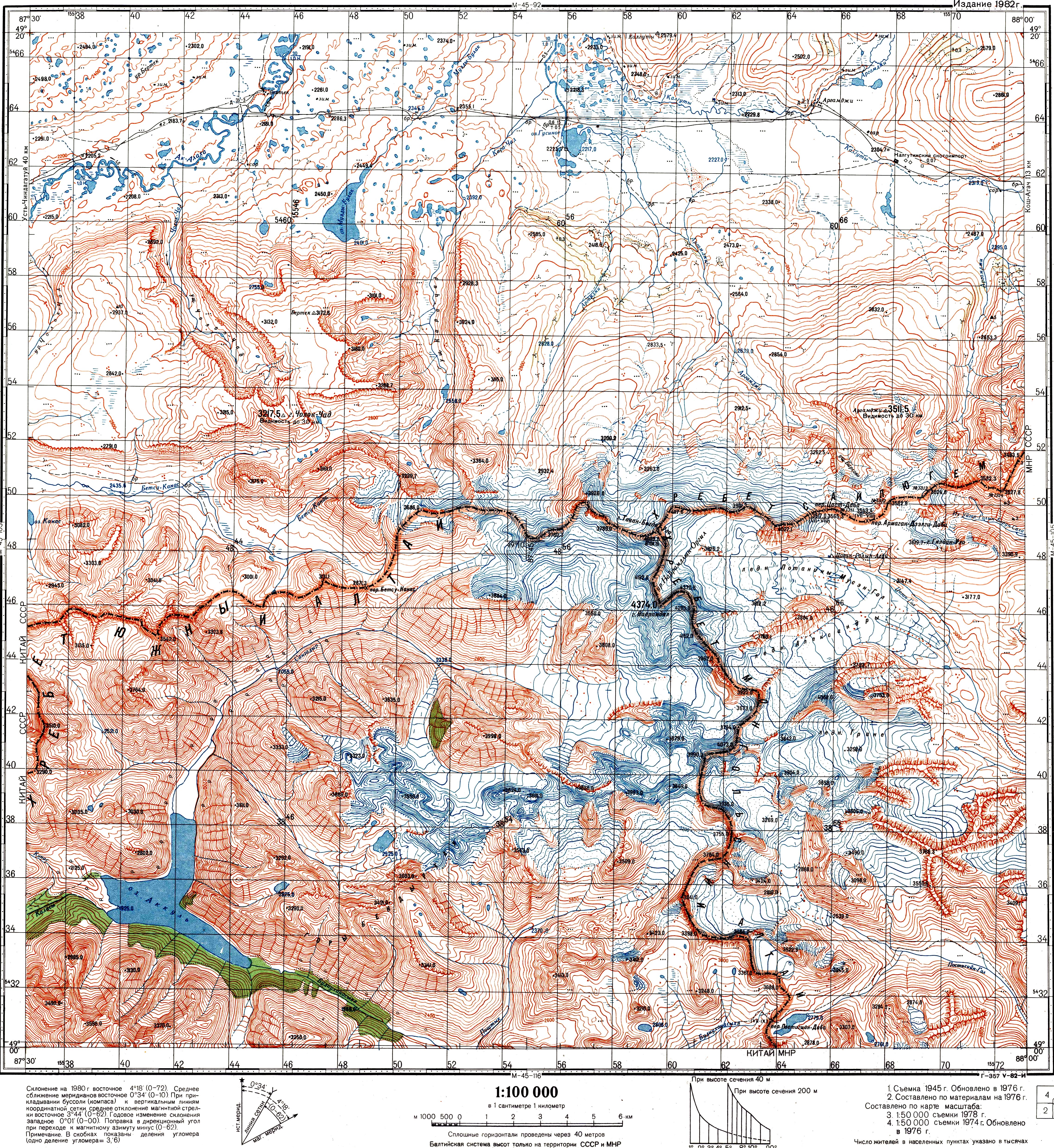
| ⚫ | '''フィティン山'''({{lang-mn|Хүйтэн оргил}}、{{lang-zh|輝騰山}}、'''フイテン山'''とも)または'''友誼峰'''(ゆうぎほう)<ref>{{Cite book|和書 |author = ティエリ・サンジュアン |year = 2017 |title = 地図で見る中国ハンドブック |publisher = [[原書房]] |page = 8 |isbn = 978-4-562-05422-0}}</ref>は、[[中華人民共和国]]と[[モンゴル国]]の[[国境]]にある[[山]]である。[[標高]]は4,374メートル(4,356メートルとも)で、モンゴル国の[[最高峰]]である。[[ロシア]]、中国、モンゴルの[[国境]]地帯に連なる[[タワン・ボグド]]連山の五つの峰の一つで、山頂は[[万年雪]]に覆われている。山名はモンゴル語で「寒い山」の意味である。 |
||
かつてはこの山が「ナイラムダル山」(Найрамдал Уул, Nairamdal Uul)と呼ばれていた。これはモンゴル語で「友情の山」の意味で、中国語では友誼峰となる<ref name=krumweide2014.499>See e.g. the index in {{harvnb|Krumwiede|Kamp|Leonard|Kargel|2014}}; or see the Soviet [http://www.mountain.ru/world_mounts/altai/2006/M45-104.jpg Topo map M45-104], scale 1:100,000, where the name Mt. Nairamdal (г. Найрамдал) is associated with the peak whose elevation is 4374.0 m. The highest peak is also referred to as Nairamdal in {{harvnb|Chistyakov|Ganiushkin|2015|p=209}}</ref>。現在、{{仮リンク|ナイラムダル山|en|Nairamdal Peak|redirect=1}}はタワン・ボグドの別の山の名前になっているが、中国語名の友誼峰はそのままになっている。 |
|||
[[ロシア]]、中国、モンゴルの[[国境]]地帯に連なる[[タワン・ボグド]]連山の五つの峰の一つで、山頂は[[万年雪]]に覆われている。1963年にモンゴル政府の支援を受けたモンゴル隊が初登頂に成功した。 |
|||
1963年にモンゴル政府の支援を受けたモンゴル隊が初登頂に成功した。 |
|||
== 脚注 == |
== 脚注 == |
||
{{Reflist}} |
{{Reflist}} |
||
==参考文献== |
|||
*{{citation |
|||
|editor-first=Martin |editor-last=Culshaw|editor2-first= Victor |editor2-last=Osipov|editor3-first= S.J. |editor3-last=Booth|editor4-first= A.S. |display-editors = 3 |editor4-last=Victorov |
|||
|publisher=Springer |year=2015 |
|||
|isbn=940179538X |
|||
|title=Environmental Security of the European Cross-Border Energy Supply Infrastructure NATO Science for Peace and Security Series C: Environmental Security |
|||
|url= https://books.google.com/books?id=kPUSBgAAQBAJ&pg=PA207 |
|||
|contribution=Glaciation and Thermokarst Phenomena and Natural Disasters in the Mountains of North-West Inner Asia |
|||
|first=K. V.|last=Chistyakov|first2= D. A. |last2=Ganiushkin |
|||
|pages=207–218}} |
|||
* {{citation |
|||
|first=Brandon S.|last=Krumwiede |
|||
|first2= Ulrich |last2=Kamp |
|||
|first3= Gregory J. |last3=Leonard |
|||
|first4= Jeffrey S. |last4=Kargel |
|||
|first5=Avirmed |last5=Dashtseren |
|||
|first6=Michael |last6=Walther |
|||
|contribution=Recent Glacier Changes in the Mongolian Altai Mountains: Case Studies from Munkh Khairkhan and Tavan Bogd |
|||
|editor-first=Jeffrey Stuart |editor-last=Kargel |
|||
|publisher=Springer |year=2014 |
|||
|isbn=3540798188 |
|||
|title=Global Land Ice Measurements from Space |
|||
|series=Springer-Praxis series in geophysics |
|||
|url= https://books.google.com/books?id=sdkkBAAAQBAJ&pg=PA481 |
|||
|pages=481–509 |
|||
}} |
|||
== 外部リンク == |
== 外部リンク == |
||
2019年11月15日 (金) 04:36時点における版
| フィティン山 / 友誼峰 | |
|---|---|
| ナイラムダル山 | |
 フィティン山 / 友誼峰 モンゴルにおける位置 | |
| 最高地点 | |
| 標高 | 4,374 m (14,350 ft) [1] |
| プロミネンス | 2,342 m (7,684 ft) [2] |
| アイソレーション | 115キロメートル (71 mi) |
| 総称 | モンゴル最高峰 ウルトラ・プロミネント峰 |
| 座標 | 北緯49度8分45秒 東経87度49分8秒 / 北緯49.14583度 東経87.81889度座標: 北緯49度8分45秒 東経87度49分8秒 / 北緯49.14583度 東経87.81889度 [3] |
| 地形 | |
| 所在地 | |
| 所属山脈 | タワン・ボグド連山 アルタイ山脈 |
| 登山 | |
| 初登頂 | 1963年 モンゴル隊 |
| フィティン山 | |
|---|---|
| 各種表記 | |
| 繁体字: | 友誼峰 |
| 簡体字: | 友谊峰 |
| 拼音: | Yǒuyì Fēng |
| 日本語読み: | ゆうぎほう |
| 英文: | Khüiten Peak |
フィティン山(モンゴル語: Хүйтэн оргил、中国語: 輝騰山、フイテン山とも)または友誼峰(ゆうぎほう)[4]は、中華人民共和国とモンゴル国の国境にある山である。標高は4,374メートル(4,356メートルとも)で、モンゴル国の最高峰である。ロシア、中国、モンゴルの国境地帯に連なるタワン・ボグド連山の五つの峰の一つで、山頂は万年雪に覆われている。山名はモンゴル語で「寒い山」の意味である。
かつてはこの山が「ナイラムダル山」(Найрамдал Уул, Nairamdal Uul)と呼ばれていた。これはモンゴル語で「友情の山」の意味で、中国語では友誼峰となる[5]。現在、ナイラムダル山はタワン・ボグドの別の山の名前になっているが、中国語名の友誼峰はそのままになっている。
1963年にモンゴル政府の支援を受けたモンゴル隊が初登頂に成功した。
脚注
- ^ "Tavan Bogd Uul, Mongolia/China". Peakbagger.com.
{{cite web}}: Cite webテンプレートでは|access-date=引数が必須です。 (説明) - ^ "China II: Sinkiang - Xinjiang" Ultra-Prominence Page Listed here as "Nayramadlin Orgil". Peaklist.org. Retrieved 2012-02-01.
- ^ Google Maps
- ^ ティエリ・サンジュアン『地図で見る中国ハンドブック』原書房、2017年、8頁。ISBN 978-4-562-05422-0。
- ^ See e.g. the index in Krumwiede et al. 2014; or see the Soviet Topo map M45-104, scale 1:100,000, where the name Mt. Nairamdal (г. Найрамдал) is associated with the peak whose elevation is 4374.0 m. The highest peak is also referred to as Nairamdal in Chistyakov & Ganiushkin 2015, p. 209
参考文献
- Chistyakov, K. V.; Ganiushkin, D. A. (2015), “Glaciation and Thermokarst Phenomena and Natural Disasters in the Mountains of North-West Inner Asia”, in Culshaw, Martin; Osipov, Victor; Booth, S.J. et al., Environmental Security of the European Cross-Border Energy Supply Infrastructure NATO Science for Peace and Security Series C: Environmental Security, Springer, pp. 207–218, ISBN 940179538X
- Krumwiede, Brandon S.; Kamp, Ulrich; Leonard, Gregory J.; Kargel, Jeffrey S.; Dashtseren, Avirmed; Walther, Michael (2014), “Recent Glacier Changes in the Mongolian Altai Mountains: Case Studies from Munkh Khairkhan and Tavan Bogd”, in Kargel, Jeffrey Stuart, Global Land Ice Measurements from Space, Springer-Praxis series in geophysics, Springer, pp. 481–509, ISBN 3540798188
外部リンク
- 新疆の主な山々 - Peaklist.org (英語)
- タバン・ボグド連山 - Peakbagger.com (英語)
- フィティン山 - Peakware.com (英語)
この項目は、中国の地理に関連した書きかけの項目です。この項目を加筆・訂正などしてくださる協力者を求めています(P:中国/PJ:中国)。 |
この項目は、山岳に関連した書きかけの項目です。この項目を加筆・訂正などしてくださる協力者を求めています(PJ山)。 |