
「カディス湾 (大)」の版間の差分
m編集の要約なし |
仮リンク修正 |
||
| 39行目: | 39行目: | ||
}} |
}} |
||
カディス湾は大西洋北東部、北緯34度から37度15分、西経6度-9度45分の範囲にある<ref name="Oliver 2011">Oliver G., Rodrigues C & Cunha M. R. (2011). "Chemosymbiotic bivalves from the mud volcanoes of the Gulf of Cadiz, NE Atlantic, with descriptions of new species of Solemyidae, Lucinidae and Vesicomyidae". ''[[ZooKeys]]'' '''113''': 1-38. {{doi|10.3897/ZooKeys.113.1402}}.</ref>。[[イベリア半島]]南西部と[[アフリカ大陸]]のモロッコに挟まれており、東部にはヨーロッパ大陸とアフリカ大陸を隔てる[[ジブラルタル海峡]]がある<ref name="Oliver 2011"/>。西端はポルトガル・[[ファーロ]]に近い{{仮リンク|サンタ・マリーア岬|en|Cabo de Santa Maria (Faro)}}、東端はスペイン・アンダルシア州の[[トラファルガー岬]]である。 |
カディス湾は大西洋北東部、北緯34度から37度15分、西経6度-9度45分の範囲にある<ref name="Oliver 2011">Oliver G., Rodrigues C & Cunha M. R. (2011). "Chemosymbiotic bivalves from the mud volcanoes of the Gulf of Cadiz, NE Atlantic, with descriptions of new species of Solemyidae, Lucinidae and Vesicomyidae". ''[[ZooKeys]]'' '''113''': 1-38. {{doi|10.3897/ZooKeys.113.1402}}.</ref>。[[イベリア半島]]南西部と[[アフリカ大陸]]のモロッコに挟まれており、東部にはヨーロッパ大陸とアフリカ大陸を隔てる[[ジブラルタル海峡]]がある<ref name="Oliver 2011"/>。西端はポルトガル・[[ファーロ]]に近い{{仮リンク|サンタ・マリーア岬 (ファロ)|en|Cabo de Santa Maria (Faro)|label=サンタ・マリーア岬}}、東端はスペイン・アンダルシア州の[[トラファルガー岬]]である。 |
||
=== 大小の「カディス湾」 === |
=== 大小の「カディス湾」 === |
||
2017年9月2日 (土) 12:37時点における版
このページ名「カディス湾 (大)」は暫定的なものです。(2015年11月) |
| カディス湾 (Golfo de Cádiz) | |
|---|---|
 | |
| 位置 | アンダルシア州(スペイン)、アルガルヴェ地方(ポルトガル) |
| 河川 | グアディアナ川(742km)、グアダルキビール川(666km)、グアダレーテ川(157km)、オディエル川(150km) |
| 海洋 | 大西洋 |
| 国 |
|
| 主な沿岸自治体 | ファーロ、オリョン、タビラ(以上ポルトガル)、ウエルバ、サンルーカル・デ・バラメーダ、ロタ、チピオナ、カディス、バルバテ |
カディス湾(スペイン語: Golfo de Cádiz)は、イベリア半島南西部にある、大西洋に対して弧を描いた湾。沿岸はスペインとポルトガルの2か国にまたがっている。
地理
河川
グアディアナ川とグアダルキビール川という2本の大河川がカディス湾に注いでおり、その他にはオディエル川、ティント川、グアダレーテ川などがカディス湾に注いでいる。
位置

カディス湾は大西洋北東部、北緯34度から37度15分、西経6度-9度45分の範囲にある[1]。イベリア半島南西部とアフリカ大陸のモロッコに挟まれており、東部にはヨーロッパ大陸とアフリカ大陸を隔てるジブラルタル海峡がある[1]。西端はポルトガル・ファーロに近いサンタ・マリーア岬、東端はスペイン・アンダルシア州のトラファルガー岬である。
大小の「カディス湾」
カディス付近には面積約100km2のカディス湾(Bahía de Cádiz)が発達している。スペイン語ではGolfoとBahía、英語ではGulfとBayの単語は区別されるが、日本語ではどちらも「カディス湾」と表記される。カディス湾(Golfo de Cádiz)は熊野灘や鹿島灘などの規模に近く、カディス湾(Bahía de Cádiz)は博多湾や英虞湾などの規模に近い。
-
 カディス湾の地図
 -
 カディス湾とその周辺の地図
 -
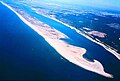 イベリア半島南西岸に発達した砂州


生物相
2003年にはカディス湾の大規模な泥火山地で化学共生による生物相の発生が確認された[1][2]。深海に生息する有鬚動物門の生物が主に確認され、また腹足類や二枚貝類、多毛類、甲殻類、棘皮動物も確認された。Madrepora属やLophelia属などの枯れたサンゴも記録された[2]。この化学共生による二枚貝類は2011年の再調査時にもカディス湾の泥火山地で収集された[1]。この調査時には以下の種が報告されている[1]。化学共生の群衆内では固有種の濃度が高かった[1]。
- キヌタレガイ科 : Acharax gadirae、Solemya elarraichensis
- イガイ科 : Bathymodiolus mauritanicus、Idas sp.
- ツキガイ科 : Lucinoma asapheus
- ハナシガイ科 : Thyasira vulcolutre、Spinaxinus sentosus
- オトヒメハマグリ科 : Isorropodon perplexum、Isorropodon megadesmus、Callogonia cyrili、Christineconcha regab、Laubiericoncha chuni、Pliocardia sp.
脚注
- ^ a b c d e f Oliver G., Rodrigues C & Cunha M. R. (2011). "Chemosymbiotic bivalves from the mud volcanoes of the Gulf of Cadiz, NE Atlantic, with descriptions of new species of Solemyidae, Lucinidae and Vesicomyidae". ZooKeys 113: 1-38. doi:10.3897/ZooKeys.113.1402.
- ^ a b Pinheiro, L.M., Ivanov, M.K., Sautkin, A., Akhmanov, G., Magalhaes, V.H., Volkonskaya, A., Monteiro, J.H., Somoza, L., Gardner, J., Hamouni, N., Cunha, M.R., 2003. Mud volcanism in the Gulf of Cadiz: results from the TTR-10 cruise. Marine Geology 195, 131–151.
文献
- Gutscher, M.-A., Dominguez, S., Westbrook, G., Le Roy, P., Rosas, F.M., Duarte, J.C., Terrinha, P., Miranda, J.M., Gailler, A., Sallares, V., and Bartolome, R., 2012. The Gibraltar subduction: A decade of new geophysical data. Tectonophysics (invited review paper) v. 574-575, p. 72-91, doi:10.1016/j.tecto.2012.08.038.
- Gutscher, M.-A., Malod, J., Rehault, J.-P., Contrucci, I., Klingelhoefer, F., Mendes-Victor, L., Spakman, W., 2002. Evidence for active subduction beneath Gibraltar. Geology 30, 1071–1074.
- Zitellini, N., Gracia, E., Matias, L., Terrinha, P., Abreu, M.A., DeAlteriis, G., Henriet, J.P., Danobeitia, J.J., Masson, D., Mulder, T., Ramella, R., Somoza, L., Diez, S., 2009. The quest for NW Africa–SW Eurasia plate boundary west of Gibraltar. Earth and Planetary Science Letters 280, 13–50. doi:10.1016/j.epsl.2008.12.005.
- Stich, D., Serpelloni, E., Mancilla, F.d.L., Morales, J., 2006. Kinematics of the Iberia–
Maghreb plate contact from seismic moment tensors and GPS observations. Tectonophysics 426, 295–317. http://dx.doi.org/10.1016/j.tecto.2006.08.004.
- Koulali, A., Ouzar, D., Tahayt, A., King, R.W., Vernant, P., Reilinger, R.E., McClusky, S., Mourabit, T., Davila, J.M., Amraoui, N., 2011. New GPS constraints on active defor- mation along the Africa–Iberia plate boundary. Earth and Planetary Science Letters 308, 211–217. http://dx.doi.org/10.1016/j.epsl.2011.05.048.
- Bartolome, R., Gracia, E., Stich, D., Martinez-Loriente, S., Klaeschen, D., Mancilla, F., Lo Iacona, C., Danobeitia, J.J., and Zitellini, N., 2012. Evidence for active strike-slip faulting along the Eurasia-Africa convergence zone: Implications for seismic hazard in the southwest Iberian margin. Geology, v. 40, p. 495–498; doi:10.1130/G33107.1
関連項目
座標: 北緯36度50分 西経7度10分 / 北緯36.833度 西経7.167度
この項目は、スペインに関連した書きかけの項目です。この項目を加筆・訂正などしてくださる協力者を求めています(Portal:ヨーロッパ/Portal:スペイン)。 |