
ファイル:Florida US Congressional District 5 (since 2013).tif

この TIF ファイルのこの PNG プレビューのサイズ: 800 × 466 ピクセル. その他の解像度: 320 × 186 ピクセル | 640 × 373 ピクセル | 1,024 × 596 ピクセル | 1,738 × 1,012 ピクセル。
元のファイル (1,738 × 1,012 ピクセル、ファイルサイズ: 2.1メガバイト、MIME タイプ: image/tiff)
ウィキメディア・コモンズのファイルページにある説明を、以下に表示します。
|
概要

|
この地図画像は、ベクターイメージである SVG ファイルとして再作成されるべきです。これにはいくつかの利点があります。詳しくはCommons:Media for cleanupを参照してください。この画像の SVG 形式がすでに利用可能である場合は、アップロードしてください。アップロード後、この画像にあるこのテンプレートを{{Vector version available|新しい画像ファイル名.svg}}テンプレートで置き換えてください。
|
| 解説 |
English: Boundaries for Florida's 5th US Federal Congressional District. |
| 日付 | |
| 原典 | GIS shapefile data created by the United States Department of the Interior, as part of the "1 Million Scale" geospatial data project. Retrieved from: http://nationalatlas.gov/atlasftp-1m.html?openChapters=#chpbound |
| 作者 | GIS (congressional districts, 2013) shapefile data was created by the United States Department of the Interior. 2: Data was rendered using ArcGIS® software by Esri. 3: File developed for use on Wikipedia and elsewhere by 7partparadigm. |
ライセンス
This map was obtained from an edition of the National Atlas of the United States. Like almost all works of the U.S. federal government, works from the National Atlas are in the public domain in the United States.
Online access: NationalAtlas.gov | 1970 print edition: Library of Congress, Perry-Castañeda Library
|
ファイルの履歴
過去の版のファイルを表示するには、その版の日時をクリックしてください。
| 日付と時刻 | サムネイル | 寸法 | 利用者 | コメント | |
|---|---|---|---|---|---|
| 現在の版 | 2014年3月16日 (日) 03:14 | 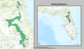 | 1,738 × 1,012 (2.1メガバイト) | 7partparadigm | User created page with UploadWizard |
ファイルの使用状況
以下のページがこのファイルを使用しています:
グローバルなファイル使用状況
以下に挙げる他のウィキがこの画像を使っています:
- de.wikipedia.org での使用状況
- en.wikipedia.org での使用状況
- fr.wikipedia.org での使用状況
- hu.wikipedia.org での使用状況