
ファイル:Cumulonimbus Cloud over Africa (color).jpg

元のファイル (3,032 × 2,008 ピクセル、ファイルサイズ: 3.1メガバイト、MIME タイプ: image/jpeg)
ウィキメディア・コモンズのファイルページにある説明を、以下に表示します。
|
.jpg?uselang=ja)
.jpg?uselang=ja)
.jpg?uselang=ja&action=history)
.jpg)
概要
| 解説 |
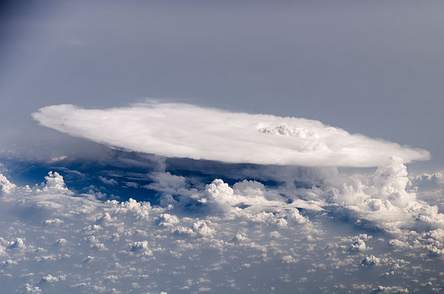
English: Perhaps the most impressive of cloud formations, cumulonimbus (from the Latin for “pile” and “rain cloud”) clouds form due to vigorous convection (rising and overturning) of warm, moist, and unstable air. Surface air is warmed by the Sun-heated ground surface and rises; if sufficient atmospheric moisture is present, water droplets will condense as the air mass encounters cooler air at higher altitudes. The air mass itself also expands and cools as it rises due to decreasing atmospheric pressure, a process known as adiabatic cooling. This type of convection is common in tropical latitudes year-round and during the summer season at higher latitudes.
As water in the rising air mass condenses and changes from a gas to a liquid state, it releases energy to its surroundings, further heating the surrounding air and leading to more convection and rising of the cloud mass to higher altitudes. This leads to the characteristic vertical “towers” associated with cumulonimbus clouds, an excellent example of which is visible in this astronaut photograph. If enough moisture is present to condense and heat the cloud mass through several convective cycles, a tower can rise to altitudes of approximately 10 kilometers at high latitudes and to 20 kilometers in the tropics before encountering a region of the atmosphere known as the tropopause—the boundary between the troposphere and the stratosphere. The tropopause is characterized by a strong temperature inversion. Beyond the tropopause, the air no longer gets colder as altitude increases. The tropopause halts further upward motion of the cloud mass. The cloud tops flatten and spread into an anvil shape, as illustrated by this astronaut photograph. The photo was taken from a viewpoint that was at an angle from the vertical, rather than looking straight down towards the Earth’s surface. The image, taken while the International Space Station was located over western Africa near the Senegal-Mali border, shows a fully formed anvil cloud with numerous smaller cumulonimbus towers rising near it. The high energy levels of these storm systems typically make them hazardous due to associated heavy precipitation, lightning, high wind speeds and possible tornadoes.
|
||||||||||||||||||||||||||||||||||||||||||||
| 日付 | |||||||||||||||||||||||||||||||||||||||||||||
| 原典 | jsc.nasa.gov | ||||||||||||||||||||||||||||||||||||||||||||
| 作者 | NASA/ISS 16 | ||||||||||||||||||||||||||||||||||||||||||||
この画像には画像編集が施されています。原本に対して次のデジタル的な変更が行われました。
|
ライセンス
| このファイルはアメリカ航空宇宙局(NASA)によって作成されたものです。NASAの著作権の方針では、特記事項が無い場合、NASAの資料はパブリックドメインとなります。 (詳しくはTemplate:PD-USGov、NASAの著作権の方針について(英語)又はジェット推進研究所(JPL)の画像使用に関するガイドライン(英語)をご覧ください。) |
||
 |
注意事項:
|
ファイルの履歴
過去の版のファイルを表示するには、その版の日時をクリックしてください。
| 日付と時刻 | サムネイル | 寸法 | 利用者 | コメント | |
|---|---|---|---|---|---|
| 現在の版 | 2013年3月24日 (日) 00:39 | | 3,032 × 2,008 (3.1メガバイト) | Keraunoscopia | User created page with UploadWizard |
ファイルの使用状況
以下のページがこのファイルを使用しています:
グローバルなファイル使用状況
以下に挙げる他のウィキがこの画像を使っています:
- bg.wikipedia.org での使用状況
- he.wikipedia.org での使用状況
- pl.wikipedia.org での使用状況
- pt.wikipedia.org での使用状況
- sv.wikipedia.org での使用状況
- vi.wikipedia.org での使用状況
.jpg)