
ファイル:Satellite image of Philippines in March 2002.jpg

このプレビューのサイズ: 460 × 600 ピクセル。 その他の解像度: 184 × 240 ピクセル | 368 × 480 ピクセル | 589 × 768 ピクセル | 785 × 1,024 ピクセル | 1,570 × 2,048 ピクセル | 4,600 × 6,000 ピクセル。
元のファイル (4,600 × 6,000 ピクセル、ファイルサイズ: 3.58メガバイト、MIME タイプ: image/jpeg)
ウィキメディア・コモンズのファイルページにある説明を、以下に表示します。
|
概要
| 解説 |
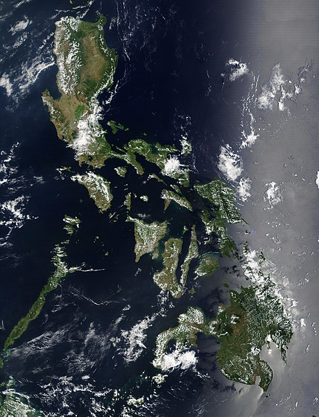
Satellite image of Philippines in March 2002. |
| 日付 | |
| 原典 | http://visibleearth.nasa.gov/view_rec.php?id=2689 |
| 作者 | NASA |
ライセンス
| このファイルはアメリカ航空宇宙局(NASA)によって作成されたものです。NASAの著作権の方針では、特記事項が無い場合、NASAの資料はパブリックドメインとなります。 (詳しくはTemplate:PD-USGov、NASAの著作権の方針について(英語)又はジェット推進研究所(JPL)の画像使用に関するガイドライン(英語)をご覧ください。) |
||
 |
注意事項:
|
ファイルの履歴
過去の版のファイルを表示するには、その版の日時をクリックしてください。
| 日付と時刻 | サムネイル | 寸法 | 利用者 | コメント | |
|---|---|---|---|---|---|
| 現在の版 | 2004年12月21日 (火) 11:32 | | 4,600 × 6,000 (3.58メガバイト) | Hautala | {{PD-USGov-NASA}} Satellite image of Philippines in March 2002. Taken from NASA's Visible Earth http://visibleearth.nasa.gov/cgi-bin/viewrecord?12847 . Description: Red dots (or outlines in the high-resolution imagery) indicate MODIS9 detection of thermal |
ファイルの使用状況
このファイルを使用しているページはありません。
グローバルなファイル使用状況
以下に挙げる他のウィキがこの画像を使っています:
- af.wikipedia.org での使用状況
- bg.wikipedia.org での使用状況
- bn.wikipedia.org での使用状況
- ca.wikipedia.org での使用状況
- da.wikipedia.org での使用状況
- de.wikipedia.org での使用状況
- de.wikinews.org での使用状況
- en.wikipedia.org での使用状況
- Outline of the Philippines
- Deforestation by continent
- Deforestation in the Philippines
- Wikipedia:Featured picture candidates/Satellite image of the Philippines
- Wikipedia:Featured picture candidates/September-2012
- Wikipedia:Featured picture candidates/February-2014
- Wikipedia:Featured picture candidates/Philippines (Satellite)
- en.wikiversity.org での使用状況
- en.wiktionary.org での使用状況
- fi.wikipedia.org での使用状況
- gl.wikipedia.org での使用状況
- he.wikipedia.org での使用状況
- תבנית:הידעת? 5 בנובמבר - סדרה 2
- פורטל:ארצות הברית/הידעת?/קטעי הידעת
- פורטל:ארצות הברית/הידעת?/50
- פורטל:יפן/הידעת?/קטעי הידעת
- תבנית:הידעת? 5 בנובמבר 2014
- ויקיפדיה:הידעת?/2014/נובמבר
- ויקיפדיה:הידעת?/2016/נובמבר
- תבנית:הידעת? 5 בנובמבר 2016
- ויקיפדיה:הידעת?/2018/נובמבר
- תבנית:הידעת? 18 בנובמבר 2018
- תבנית:הידעת? 1 בנובמבר 2019
- ויקיפדיה:הידעת?/2019/נובמבר
- ויקיפדיה:הידעת?/2021/נובמבר
- תבנית:הידעת? 7 בנובמבר 2021
- פורטל:יפן/הידעת?/23
- תבנית:הידעת? 5 בנובמבר 2023
- ויקיפדיה:הידעת?/2023/נובמבר
- ht.wikipedia.org での使用状況
- incubator.wikimedia.org での使用状況
- mdf.wikipedia.org での使用状況
- nl.wikipedia.org での使用状況
- nl.wiktionary.org での使用状況
- no.wikipedia.org での使用状況
- pap.wikipedia.org での使用状況
- pl.wikinews.org での使用状況
- qu.wikipedia.org での使用状況
- sk.wikipedia.org での使用状況
- sm.wikipedia.org での使用状況
- sr.wikinews.org での使用状況
このファイルのグローバル使用状況を表示する。