
ファイル:Mao Kun map - Singapore.png

このプレビューのサイズ: 799 × 344 ピクセル。 その他の解像度: 320 × 138 ピクセル | 640 × 276 ピクセル | 1,289 × 555 ピクセル。
元のファイル (1,289 × 555 ピクセル、ファイルサイズ: 473キロバイト、MIME タイプ: image/png)
ウィキメディア・コモンズのファイルページにある説明を、以下に表示します。
|
概要
| 解説 |
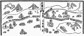
English: A Mao Kun map showing Singapore and part of the east coast of the Malay peninsula. Temasek (early Singapore; " 淡馬錫 ) is marked at the top left corner, others identified by Wheatley are Pulau Brani (琵琶嶼), Blakang Mati (長腰嶼, Sentosa), Pedra Branca (白礁), Pulau Tinggi (將軍帽), Pulau Aur (東竹山 and 西竹山), Pahang River estuary (彭杭港), and Pulau Tioman (苧麻山). Long Ya Men (龍牙門) on the map is said to mark the entrance to Keppel Harbour. Note that different sources may identify the islands differently, especially the islands of Singapore. J. V. G. Mills for example identified 長腰嶼 as Pulau Satumu and 琵琶嶼 as Pulau Sakijang Pelepah. |
| 日付 | 17世紀 |
| 原典 | Scanned from Paul Wheatley (1961年) The Golden Khersonese: Studies in the Historical Geography of the Malay Peninsula before A.D. 1500、クアラルンプール: University of Malaya Press OCLC: 504030596. Originally from the Wubei Zhi (Treatise on Armament Technology), a 17th century work with maps based on material dated to the voyages of Zheng He (early 15th century). |
| 作者 | Mao Yuanyi (1594–1640?), editor of the Wubei Zhi; and an unknown cartographer. |
ライセンス
|
このファイルは、パブリックドメインの状態にある平面的な美術の著作物を写真術によって忠実に複製したものです。このような複製はアメリカ合衆国においてパブリックドメインの状態にあります。その他の地域では再利用に制限がかかる場合があります。詳しくはReuse of PD-Art photographsをご覧ください。美術の著作物としての原図は、次の理由によりパブリックドメインの状態にあります。
| ||||
ファイルの履歴
過去の版のファイルを表示するには、その版の日時をクリックしてください。
| 日付と時刻 | サムネイル | 寸法 | 利用者 | コメント | |
|---|---|---|---|---|---|
| 現在の版 | 2015年7月30日 (木) 14:42 | | 1,289 × 555 (473キロバイト) | Hzh | User created page with UploadWizard |
ファイルの使用状況
このファイルを使用しているページはありません。
グローバルなファイル使用状況
以下に挙げる他のウィキがこの画像を使っています:
- cs.wikipedia.org での使用状況
- en.wikipedia.org での使用状況
- id.wikipedia.org での使用状況
- it.wikipedia.org での使用状況
- ko.wikipedia.org での使用状況
- ms.wikipedia.org での使用状況
- ru.wikipedia.org での使用状況
- ta.wikipedia.org での使用状況
- th.wikipedia.org での使用状況
- tl.wikipedia.org での使用状況
- uk.wikipedia.org での使用状況
- zh.wikipedia.org での使用状況