
ファイル:Ireland geographical map.png
高解像度版はありません。
Ireland_geographical_map.png (150 × 190 ピクセル、ファイルサイズ: 50キロバイト、MIME タイプ: image/png)
ウィキメディア・コモンズのファイルページにある説明を、以下に表示します。
|
| 解説 |
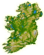
English: Topography of Ireland |
| 日付 | IotD Date 2005-03-18 |
| 原典 |
NASA: IotD ID 16853 – http://visibleearth.nasa.gov/view_rec.php?id=17124 |
| 作者 | NASA, see Image:Topography Ireland.jpg for more information |
| 許可 (ファイルの再利用) |
public domain |
| その他のバージョン | original, bigger version at Image:Topography Ireland.jpg |
| このファイルはアメリカ航空宇宙局(NASA)によって作成されたものです。NASAの著作権の方針では、特記事項が無い場合、NASAの資料はパブリックドメインとなります。 (詳しくはTemplate:PD-USGov、NASAの著作権の方針について(英語)又はジェット推進研究所(JPL)の画像使用に関するガイドライン(英語)をご覧ください。) |
||
 |
注意事項:
|
ファイルの履歴
過去の版のファイルを表示するには、その版の日時をクリックしてください。
| 日付と時刻 | サムネイル | 寸法 | 利用者 | コメント | |
|---|---|---|---|---|---|
| 現在の版 | 2005年7月11日 (月) 11:39 | | 150 × 190 (50キロバイト) | Kanchelskis | Map of Ireland lightened. Author:me {{GFDL}} Category: Ireland |
ファイルの使用状況
このファイルを使用しているページはありません。
グローバルなファイル使用状況
以下に挙げる他のウィキがこの画像を使っています:
- bew.wikipedia.org での使用状況
- de.wikipedia.org での使用状況
- en.wikipedia.org での使用状況
- User:Jtdirl
- User:Kwekubo
- Dingle Peninsula
- User:Zoney
- Iveragh Peninsula
- User:Ropers
- User:Gerry Lynch
- User:AndrewH
- User:Ebelular
- Inishowen
- User:Fergananim
- Mizen Head
- Sheep's Head
- Old Head of Kinsale
- User:Rye 212
- Ards Peninsula
- User:Blorg
- User:Wexfordman
- User:Meabhar~enwiki
- Howth Head
- User:Sean3000
- User:Notjim
- User:Jasonm
- User:Kgaughan
- Beara Peninsula
- User:John Carroll
- User:Bjimba
- User talk:Lochaber
- Fanad
- User:Hetch
- Islandmagee
- User:Wikipedian231
- User:Jdorney
- User:Merlante
- User:Lugnad
- Slieve League
- User:Ben-w
- Hook Peninsula
- User:Polar ice
- User:Dowlingm
- User:Frure
- User:Ventolin
- User:Dkie
- User:Colm Rice
- Mullaghmore, County Sligo
- User:Damac
- User:Ian Cheese
- User:Tpower
このファイルのグローバル使用状況を表示する。