
ファイル:Iceberg A22A, South Atlantic Ocean.jpg

このプレビューのサイズ: 800 × 530 ピクセル。 その他の解像度: 320 × 212 ピクセル | 640 × 424 ピクセル | 1,024 × 678 ピクセル | 1,280 × 848 ピクセル | 2,345 × 1,553 ピクセル。
元のファイル (2,345 × 1,553 ピクセル、ファイルサイズ: 793キロバイト、MIME タイプ: image/jpeg)
ウィキメディア・コモンズのファイルページにある説明を、以下に表示します。
|
概要
| 解説 |
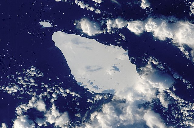
English: This astronaut photograph illustrates the remains of a giant iceberg—designated A22A— that broke off Antarctica in 2002. The iceberg was photographed at a location of 49.9 degrees south latitude, 23.8 degrees west longitude, which is about a third of the distance from South America towards Cape Town, South Africa. A22A is one of the largest icebergs to drift as far north as 50 degrees south latitude, bringing it beneath the daylight path of the International Space Station (ISS). Crew members aboard the ISS were able to locate the ice mass and photograph it, despite the great masses of clouds that often accompany winter storms in the Southern Ocean. The crew’s viewing angle was oblique (not looking straight down) from a point to the west of the berg, and the time of day was early afternoon, as shown by the orientation of the cloud shadows. Dimensions of A22A in early June were 49.9 by 23.4 kilometres, giving it an area of 622 square kilometres, or seven times the area of Manhattan Island.
|
||||||||||||||||||||||||||||||||||||||||||||||||||
| 日付 | |||||||||||||||||||||||||||||||||||||||||||||||||||
| 原典 | {{URL|example.com|optional display text}} | ||||||||||||||||||||||||||||||||||||||||||||||||||
| 作者 | Image provided by the ISS Crew Earth Observations experiment and the Image Science & Analysis Laboratory, NASA - Johnson Space Center. | ||||||||||||||||||||||||||||||||||||||||||||||||||
| 被写体の位置 | | 以下のサービスでこの位置を確認する: オープンストリートマップ |
|---|
| このタグは、添付された著作物の著作権状況を示すものではありません。通常の著作権タグも必要です。Commons:ライセンシングもご覧ください。 他言語での翻訳:
|
ライセンス
| このファイルはアメリカ航空宇宙局(NASA)によって作成されたものです。NASAの著作権の方針では、特記事項が無い場合、NASAの資料はパブリックドメインとなります。 (詳しくはTemplate:PD-USGov、NASAの著作権の方針について(英語)又はジェット推進研究所(JPL)の画像使用に関するガイドライン(英語)をご覧ください。) |
||
 |
注意事項:
|
ファイルの履歴
過去の版のファイルを表示するには、その版の日時をクリックしてください。
| 日付と時刻 | サムネイル | 寸法 | 利用者 | コメント | |
|---|---|---|---|---|---|
| 現在の版 | 2013年3月22日 (金) 15:25 | | 2,345 × 1,553 (793キロバイト) | Julian Herzog | Higher resolution and quality |
| 2009年7月5日 (日) 19:54 |  | 1,000 × 1,000 (376キロバイト) | Originalwana | {{Information |Description={{en|1=This astronaut photograph illustrates the remains of a giant iceberg—designated A22A— that broke off Antarctica in 2002. The iceberg was photographed at a location of 49.9 degrees south latitude, 23.8 degrees west lon |
ファイルの使用状況
このファイルを使用しているページはありません。
グローバルなファイル使用状況
以下に挙げる他のウィキがこの画像を使っています:
- ar.wikipedia.org での使用状況
- az.wikipedia.org での使用状況
- bn.wikipedia.org での使用状況
- cy.wikipedia.org での使用状況
- en.wikipedia.org での使用状況
- eo.wikipedia.org での使用状況
- it.wikipedia.org での使用状況
- it.wikibooks.org での使用状況
- it.wikiversity.org での使用状況
- la.wikipedia.org での使用状況
- mk.wikipedia.org での使用状況
- pt.wikipedia.org での使用状況
- sl.wikipedia.org での使用状況
- ta.wikipedia.org での使用状況
- ta.wiktionary.org での使用状況
- th.wikipedia.org での使用状況