
ファイル:Warsaw Ghetto 1940 map.tiff
この TIF ファイルのこの JPG プレビューのサイズ: 768 × 600 ピクセル. その他の解像度: 307 × 240 ピクセル | 615 × 480 ピクセル | 858 × 670 ピクセル。
元のファイル (858 × 670 ピクセル、ファイルサイズ: 1.68メガバイト、MIME タイプ: image/tiff)
ウィキメディア・コモンズのファイルページにある説明を、以下に表示します。
|
概要
| 解説 |
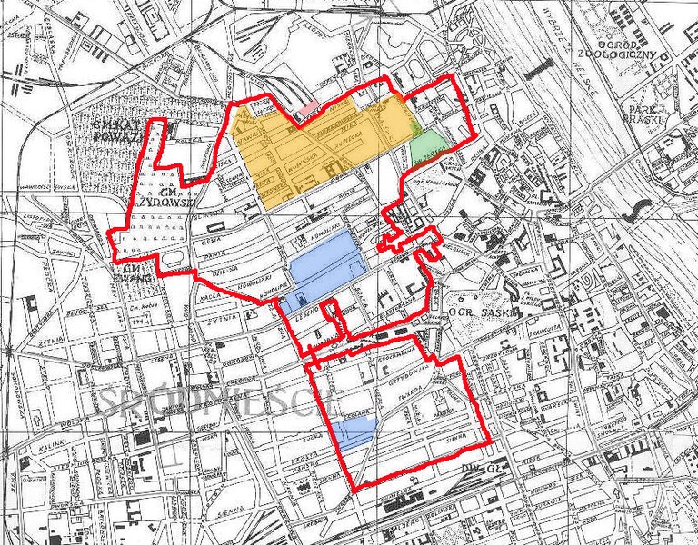
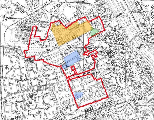
English: Warsaw Ghetto 1940 drawn on a map from 1938. Legend: Red line - the getto 1940; Yellow - the "main ghetto"; Green - the brush factory; Blue - factory and workshop area; Pink - railway platform, "Umschlagplatz". After the mass deportations of 1942 the ghetto was, in the beginning of 1943, reduced to the areas of the "main ghetto" and the factories.
Deutsch: Karte des Warschauer Ghettos in der Abgrenzung von 1940 auf einer Karte von 1938. Legende: in gelb - das Kerngebiet des Ghettos; grün - Bürstenfabrik; blau - Fabrik und Geschäfte; lila - Bahnplattform, "Umschlagplatz". Nach den Massendeportationen von 1942 wurde das Ghetto Anfang 1943 auf das Kerngebiet und das Gebiet der Fabriken eingeengt. |
| 日付 | |
| 原典 | 投稿者自身による著作物 |
| 作者 | Lihagen |
ライセンス
この作品の著作権者である私は、この作品を以下のライセンスで提供します。
このファイルはクリエイティブ・コモンズ 表示-継承 3.0 非移植ライセンスのもとに利用を許諾されています。
- あなたは以下の条件に従う場合に限り、自由に
- 共有 – 本作品を複製、頒布、展示、実演できます。
- 再構成 – 二次的著作物を作成できます。
- あなたの従うべき条件は以下の通りです。
- 表示 – あなたは適切なクレジットを表示し、ライセンスへのリンクを提供し、変更があったらその旨を示さなければなりません。これらは合理的であればどのような方法で行っても構いませんが、許諾者があなたやあなたの利用行為を支持していると示唆するような方法は除きます。
- 継承 – もしあなたがこの作品をリミックスしたり、改変したり、加工した場合には、あなたはあなたの貢献部分を元の作品とこれと同一または互換性があるライセンスの下に頒布しなければなりません。

|
この文書は、フリーソフトウェア財団発行のGNUフリー文書利用許諾書 (GNU Free Documentation License) 1.2またはそれ以降のバージョンの規約に基づき、複製や再配布、改変が許可されます。不可変更部分、表紙、背表紙はありません。このライセンスの複製は、GNUフリー文書利用許諾書という章に含まれています。 |
あなたは上記のライセンスから、どれか一つ以上を選択できます。
ファイルの履歴
過去の版のファイルを表示するには、その版の日時をクリックしてください。
| 日付と時刻 | サムネイル | 寸法 | 利用者 | コメント | |
|---|---|---|---|---|---|
| 現在の版 | 2010年11月23日 (火) 21:27 |  | 858 × 670 (1.68メガバイト) | Lihagen | {{Information |Description={{en|1=Warsaw Ghetto 1940 drawn on a map from 1938. Legend: Red line - the getto 1940; yellow - the "main ghetto"; green - the brush factory; blue - factory and workshop area; pink - umschlagplatz. In 1943 the ghetto was reduced |
ファイルの使用状況
以下の 2 ページがこのファイルを使用しています:
グローバルなファイル使用状況
以下に挙げる他のウィキがこの画像を使っています:
- de.wikipedia.org での使用状況
- it.wikipedia.org での使用状況
- nl.wikipedia.org での使用状況
- sv.wikipedia.org での使用状況
- www.wikidata.org での使用状況