
ファイル:WRF rita spread2.jpg
高解像度版はありません。
WRF_rita_spread2.jpg (311 × 504 ピクセル、ファイルサイズ: 51キロバイト、MIME タイプ: image/jpeg)
ウィキメディア・コモンズのファイルページにある説明を、以下に表示します。
|
概要
| 解説 |
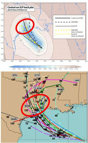
English: (Top): WRF model simulation of Hurricane Rita tracks. The model resolution is 30km. The colored field shows the lowest sea-level pressure (SLP) recorded during the last 27 hours of a 54 hour control simulation of Rita using LFO (5 class) microphysics and the Kain-Fritsch (KF) convective scheme. The superposed black line traces the model hurricane, which strikes Houston. Also shown are tracks of minimum SLP for runs using the Kessler (warm rain) scheme, the WSM3 simple ice scheme (with the Betts-Miller-Jancic convective scheme), the Kessler with reduced rain fallspeed, and WSM3 with enhanced ice fallspeed. (Bottom): The spread of NHC multi-model ensemble forecast at 06 UTC, 22 September. Note a similar ensemble spread was obtained from a single model simply by varying the model microphysics and convective schemes. Image from Jonathan Vigh, Colorado State University. |
| 原典 | http://mls.jpl.nasa.gov/research/hurricanes.php |
| 作者 | Prof. Robert Fovell (UCLA); Dr. Hui Su (JPL) |
http://www.jpl.nasa.gov/imagepolicy/
ライセンス
| このファイルはアメリカ航空宇宙局(NASA)によって作成されたものです。NASAの著作権の方針では、特記事項が無い場合、NASAの資料はパブリックドメインとなります。 (詳しくはTemplate:PD-USGov、NASAの著作権の方針について(英語)又はジェット推進研究所(JPL)の画像使用に関するガイドライン(英語)をご覧ください。) |
||
 |
注意事項:
|
ファイルの履歴
過去の版のファイルを表示するには、その版の日時をクリックしてください。
| 日付と時刻 | サムネイル | 寸法 | 利用者 | コメント | |
|---|---|---|---|---|---|
| 現在の版 | 2010年3月5日 (金) 21:49 | | 311 × 504 (51キロバイト) | Atmoz | {{Information |Description={{en|1=(Top): WRF model simulation of Hurricane Rita tracks. The model resolution is 30km. The colored field shows the lowest sea-level pressure (SLP) recorded during the last 27 hours of a 54 hour control simulation of Rita usi |
ファイルの使用状況
このファイルを使用しているページはありません。
グローバルなファイル使用状況
以下に挙げる他のウィキがこの画像を使っています:
- el.wikipedia.org での使用状況
- en.wikipedia.org での使用状況
- fa.wikipedia.org での使用状況
- fr.wikipedia.org での使用状況
- sr.wikipedia.org での使用状況