
ファイル:USGS Kīlauea image-409.jpg

このプレビューのサイズ: 776 × 600 ピクセル。 その他の解像度: 311 × 240 ピクセル | 621 × 480 ピクセル | 994 × 768 ピクセル | 1,280 × 989 ピクセル | 2,560 × 1,978 ピクセル | 3,300 × 2,550 ピクセル。
元のファイル (3,300 × 2,550 ピクセル、ファイルサイズ: 3.98メガバイト、MIME タイプ: image/jpeg)
ウィキメディア・コモンズのファイルページにある説明を、以下に表示します。
|
概要
| 解説 |
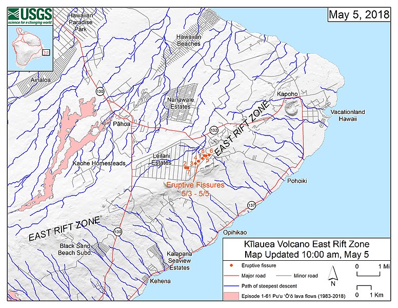
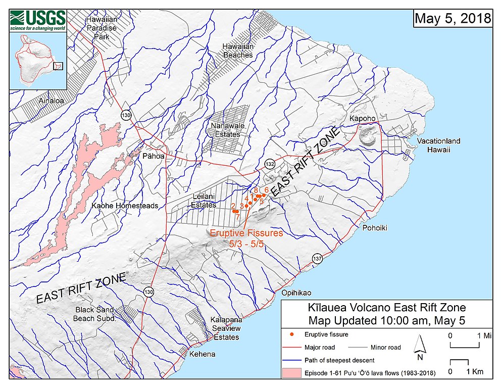
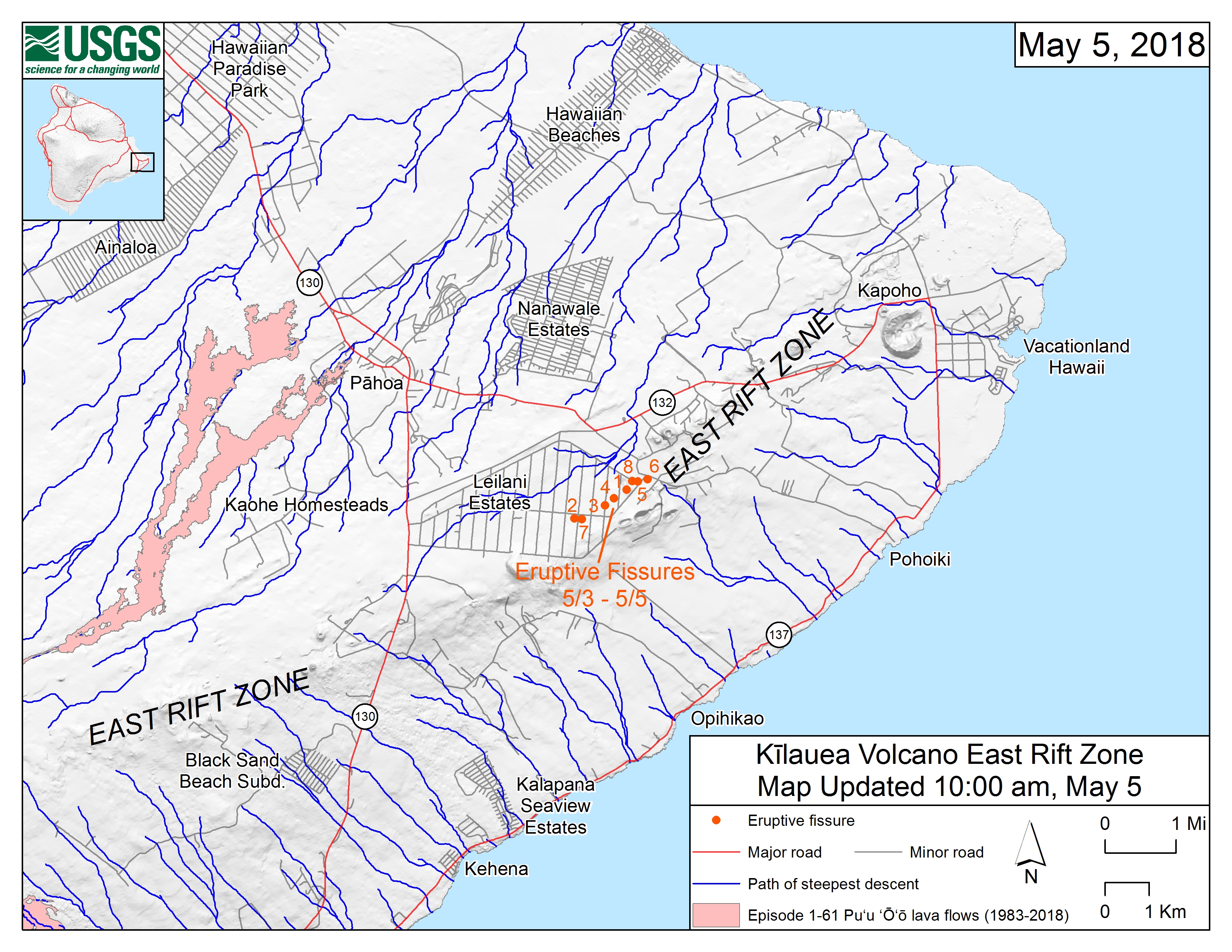
English: Map of the locations of eruptive fissures and the steepest descent paths in area of eruptive fissures, Kīlauea East Rift Zone; 10:00 a.m. HST (May 5, 2018) This map shows the locations of eruptive fissures in the order that they occurred in the Leilani Estates Subdivision as of 10:00 a.m. HST (May 5, 2018). The blue lines are paths of steepest descent that identify likely paths of a lava flow, if and when lava moves downhill from an erupting vent. The paths of steepest-descent were calculated from a 1983 digital elevation model (DEM) of the Island of Hawai‘i, created from digitized contours. Steepest-descent path analysis is based on the assumption that the DEM perfectly represents the earth's surface. DEMs, however, are not perfect, so the blue lines on this map can be used to infer only approximate lava-flow paths. The base shaded-relief map was made from the 1983 10-m (DEM). For additional explanation of steepest descent paths, see http://pubs.usgs.gov/of/2007/1264. For calculation details, ESRI shapefiles, and KMZ versions of steepest descent paths, see https://www.sciencebase.gov/catalog/item/57fd072ee4b0824b2d130eb5. |
| 日付 | |
| 原典 | https://volcanoes.usgs.gov/observatories/hvo/maps_uploads/image-409.jpg |
| 作者 | United States Geological Survey |
ライセンス
この画像およびメディアは、アメリカ合衆国内務省の実務機関であるアメリカ地質調査所に属する者が職務上作成した著作物のみで構成されているため、アメリカ合衆国国内でパブリックドメインの状態にあります。詳細についてはUSGSの著作物に関する取扱い(英語)をご覧ください。
|
ファイルの履歴
過去の版のファイルを表示するには、その版の日時をクリックしてください。
| 日付と時刻 | サムネイル | 寸法 | 利用者 | コメント | |
|---|---|---|---|---|---|
| 現在の版 | 2018年5月6日 (日) 16:44 | | 3,300 × 2,550 (3.98メガバイト) | ThT | User created page with UploadWizard |
ファイルの使用状況
以下のページがこのファイルを使用しています:
グローバルなファイル使用状況
以下に挙げる他のウィキがこの画像を使っています:
- ca.wikipedia.org での使用状況
- de.wikipedia.org での使用状況
- en.wikipedia.org での使用状況
- pt.wikipedia.org での使用状況