
ファイル:UCERF3 fig01-b.jpg

このプレビューのサイズ: 800 × 572 ピクセル。 その他の解像度: 320 × 229 ピクセル | 640 × 457 ピクセル | 1,024 × 732 ピクセル | 1,280 × 915 ピクセル | 2,088 × 1,492 ピクセル。
元のファイル (2,088 × 1,492 ピクセル、ファイルサイズ: 727キロバイト、MIME タイプ: image/jpeg)
ウィキメディア・コモンズのファイルページにある説明を、以下に表示します。
|
| 解説 |
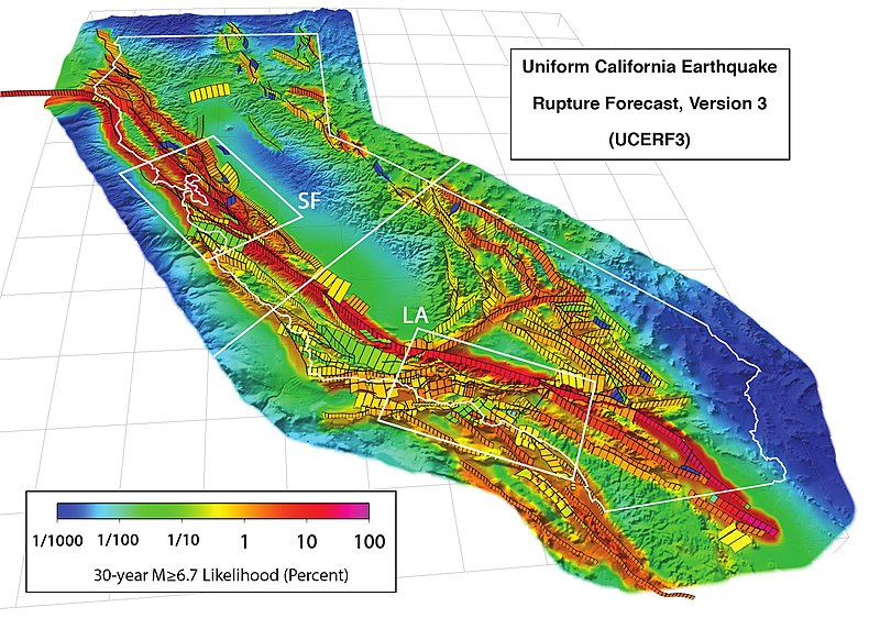
3D perspective view of California (outlined in white) and buffer zone showing the 2,606 fault sections of UCERF 3.1, with white boxes showing the San Francisco Bay (SF) and Los Angeles (LA) areas. Colors show the estimated probability of a section participating in one or more M ≥ 6.7 earthquakes in the 30 years following 2014, accounting for the current level of stress accumulated since the last earthquake. This version's scale uses percentages. Citation: WGCEP (2015-03), “UCERF3: A New Earthquake Forecast for California's Complex Fault System”, in U.S. Geological Survey[1], volume Fact Sheet 2015-3009, DOI:, ISSN 2327-6932 (online). |
|||
| 日付 | ||||
| 原典 | http://pubs.usgs.gov/fs/2015/3009/pdf/fs2015-3009.pdf | |||
| 作者 | Created by the WGCEP 2014 team, a collaboration of the U.S. Geological Survey, the California Geological Survey, and the Southern California Earthquake Center. | |||
| 許可 (ファイルの再利用) |
|
ファイルの履歴
過去の版のファイルを表示するには、その版の日時をクリックしてください。
| 日付と時刻 | サムネイル | 寸法 | 利用者 | コメント | |
|---|---|---|---|---|---|
| 現在の版 | 2016年4月19日 (火) 18:59 | | 2,088 × 1,492 (727キロバイト) | J. Johnson | {{Information |Description= 3D perspective view of California (outlined in white) and buffer zone showing the 2,606 fault sections of UCERF 3.1, with white boxes showing the San Francisco Bay (SF) and Los Angeles (LA) areas. Colors show the estimated p... |
ファイルの使用状況
以下のページがこのファイルを使用しています:
グローバルなファイル使用状況
以下に挙げる他のウィキがこの画像を使っています:
- de.wikipedia.org での使用状況
- en.wikipedia.org での使用状況
- ko.wikipedia.org での使用状況
- oc.wikipedia.org での使用状況
- uk.wikipedia.org での使用状況