
ファイル:TyphoonNesat2005.jpg

このプレビューのサイズ: 466 × 599 ピクセル。 その他の解像度: 187 × 240 ピクセル | 373 × 480 ピクセル | 597 × 768 ピクセル | 796 × 1,024 ピクセル | 1,593 × 2,048 ピクセル | 5,600 × 7,200 ピクセル。
元のファイル (5,600 × 7,200 ピクセル、ファイルサイズ: 6.11メガバイト、MIME タイプ: image/jpeg)
ウィキメディア・コモンズのファイルページにある説明を、以下に表示します。
|
概要
| 解説 |
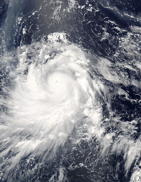
Typhoon Nesat spins over the Philippine Sea in this Moderate Resolution Imaging Spectroradiometer (MODIS) image acquired on June 3, 2005, by NASA’s Aqua satellite. At the time, Nesat had winds of 213 kilometers per hour (132 mph) with gusts to 259 kph (161 mph), making it the equivalent of a Category 4 hurricane. The storm formed near Guam on May 30 and moved slowly west northwest over the following four days. On June 3, Nesat skirted the Philippines as it curved northeast towards Japan. It is expected to miss the island nation as it moves east over the North Pacific. To the north of the typhoon, a white and brown plume of ash and steam drifts across the ocean from the Anatahan volcano. Located in the Northern Mariana Islands, just beyond the right edge of the image and immediately north of where Nesat formed, the volcano has been erupting for much of 2005. The ash plume cuts northwest across the upper right corner of the image, then curves sharply down across the upper left corner of the image. To the left of the center of the image, a silvery strip is formed by the reflection of the sun off the water’s surface. |
|||||
| 日付 | ||||||
| 原典 | http://visibleearth.nasa.gov/view_rec.php?id=6988 | |||||
| 作者 | Jacques Descloitres, MODIS Rapid Response Team, NASA/GSFC | |||||
| 許可 (ファイルの再利用) |
|

ファイルの履歴
過去の版のファイルを表示するには、その版の日時をクリックしてください。
| 日付と時刻 | サムネイル | 寸法 | 利用者 | コメント | |
|---|---|---|---|---|---|
| 現在の版 | 2006年9月6日 (水) 15:06 | | 5,600 × 7,200 (6.11メガバイト) | Good kitty | higher res |
| 2006年8月28日 (月) 11:16 |  | 2,800 × 3,600 (2.1メガバイト) | Irfanfaiz | {{Information |Description=Typhoon Nesat spins over the Philippine Sea in this Moderate Resolution Imaging Spectroradiometer (MODIS) image acquired on June 3, 2005, by NASA’s [[w:Aqua (satellit |
ファイルの使用状況
以下のページがこのファイルを使用しています:
グローバルなファイル使用状況
以下に挙げる他のウィキがこの画像を使っています:
- en.wikipedia.org での使用状況
- es.wikipedia.org での使用状況
- vi.wikipedia.org での使用状況
- zh.wikipedia.org での使用状況