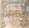
ファイル:Shimabara-Battle-Map-c17th-century.png

このプレビューのサイズ: 614 × 600 ピクセル。 その他の解像度: 246 × 240 ピクセル | 491 × 480 ピクセル | 786 × 768 ピクセル | 1,048 × 1,024 ピクセル | 2,097 × 2,048 ピクセル | 3,195 × 3,121 ピクセル。
元のファイル (3,195 × 3,121 ピクセル、ファイルサイズ: 16.15メガバイト、MIME タイプ: image/png)
ファイルの履歴
過去の版のファイルを表示するには、その版の日時をクリックしてください。
| 日付と時刻 | サムネイル | 寸法 | 利用者 | コメント | |
|---|---|---|---|---|---|
| 現在の版 | 2021年12月3日 (金) 13:22 |  | 3,195 × 3,121 (16.15メガバイト) | Artanisen | Uploaded a work by Unknown (created circa 17th century) from Yanagawa Ancient Archives - https://www.city.yanagawa.fukuoka.jp/blog-buka/2020/_7900/_7933.html with UploadWizard |
ファイルの使用状況
グローバルなファイル使用状況
以下に挙げる他のウィキがこの画像を使っています:
- ar.wikipedia.org での使用状況
- azb.wikipedia.org での使用状況
- ca.wikipedia.org での使用状況
- de.wikipedia.org での使用状況
- en.wikipedia.org での使用状況
- es.wikipedia.org での使用状況
- fr.wikipedia.org での使用状況
- he.wikipedia.org での使用状況
- hu.wikipedia.org での使用状況
- id.wikipedia.org での使用状況
- it.wikipedia.org での使用状況
- lt.wikipedia.org での使用状況
- no.wikipedia.org での使用状況
- oc.wikipedia.org での使用状況
- pl.wikipedia.org での使用状況
- pt.wikipedia.org での使用状況
- ro.wikipedia.org での使用状況
- ru.wikipedia.org での使用状況
- sv.wikipedia.org での使用状況
- th.wikipedia.org での使用状況
- tr.wikipedia.org での使用状況
- vi.wikipedia.org での使用状況
- www.wikidata.org での使用状況
- zh.wikipedia.org での使用状況
