
ファイル:Riverslosangeles.jpg

このプレビューのサイズ: 617 × 600 ピクセル。 その他の解像度: 247 × 240 ピクセル | 494 × 480 ピクセル | 790 × 768 ピクセル | 1,053 × 1,024 ピクセル | 1,739 × 1,691 ピクセル。
元のファイル (1,739 × 1,691 ピクセル、ファイルサイズ: 3.46メガバイト、MIME タイプ: image/jpeg)
ウィキメディア・コモンズのファイルページにある説明を、以下に表示します。
|
| 解説 |
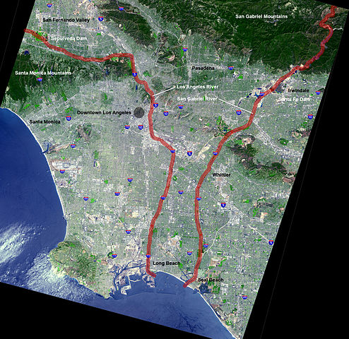
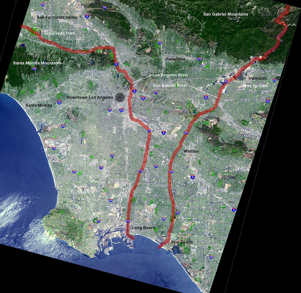
English: Map of the en:Los Angeles Basin with the Los Angeles River and San Gabriel River highlighted in red ladge |
| 日付 |
2005年10月2日 (当初のアップロード日) |
| 原典 | NASA (original) |
| 作者 | en:User:Mikeetc The overlying work is by me |
| その他のバージョン | Underlying map is an aerial map obtained from NASA (original) |
ライセンス
| このファイルはアメリカ航空宇宙局(NASA)によって作成されたものです。NASAの著作権の方針では、特記事項が無い場合、NASAの資料はパブリックドメインとなります。 (詳しくはTemplate:PD-USGov、NASAの著作権の方針について(英語)又はジェット推進研究所(JPL)の画像使用に関するガイドライン(英語)をご覧ください。) |
||
 |
注意事項:
|
| この著作物は、著作者である英語版ウィキペディアのMikeetcさんによって権利が放棄され、パブリックドメインとされました。これは全世界で適用されます。 一部の国では、これが法的に可能ではない場合があります。その場合は、次のように宣言します。 Mikeetcは、あらゆる人に対して、法により必要とされている条件を除き、如何なる条件も課すことなく、あらゆる目的のためにこの著作物を使用する権利を与えます。 |
元のアップロードログ
元のファイルページはこちら。以下の利用者は全てen.wikipediaに属します。
- 2005-10-02 11:07 Mikeetc 1739×1691× (3632156 bytes) Map of the Los Angeles Basin with the Los Angeles and San Gabriel Rivers highlighted in red Underlying map is an aerial map obtained from NASA (original: http://earthobservatory.nasa.gov/Newsroom/NewImages/images.php3?img_id=5118 The overlying work is by
- 2005-10-02 05:28 Mikeetc 1739×1691× (3631971 bytes) Map of the Los Angeles Basin with the Los Angeles and San Gabriel Rivers highlighted in red Underlying map is an aerial map obtained from NASA (original: http://earthobservatory.nasa.gov/Newsroom/NewImages/images.php3?img_id=5118 The overlying work is b
ファイルの履歴
過去の版のファイルを表示するには、その版の日時をクリックしてください。
| 日付と時刻 | サムネイル | 寸法 | 利用者 | コメント | |
|---|---|---|---|---|---|
| 現在の版 | 2009年2月25日 (水) 17:23 | | 1,739 × 1,691 (3.46メガバイト) | Evrik | {{Information |Description={{en|Map of the en:Los Angeles Basin with the en:Los Angeles River and San Gabriel River highlighted in red ladge}} |Source=Transferred from [http://en.wikipedia.org en.wikipedia |
ファイルの使用状況
以下のページがこのファイルを使用しています:
グローバルなファイル使用状況
以下に挙げる他のウィキがこの画像を使っています:
- arz.wikipedia.org での使用状況
- ca.wikipedia.org での使用状況
- en.wikipedia.org での使用状況
- fr.wikipedia.org での使用状況
- he.wikipedia.org での使用状況
- pt.wikipedia.org での使用状況
- simple.wikipedia.org での使用状況