
ファイル:Rainbow Bridge National Monument EO-1.jpg

このプレビューのサイズ: 600 × 600 ピクセル。 その他の解像度: 240 × 240 ピクセル | 480 × 480 ピクセル | 768 × 768 ピクセル | 1,024 × 1,024 ピクセル | 2,000 × 2,000 ピクセル。
元のファイル (2,000 × 2,000 ピクセル、ファイルサイズ: 2.76メガバイト、MIME タイプ: image/jpeg)
ウィキメディア・コモンズのファイルページにある説明を、以下に表示します。
|
概要
| 解説 |
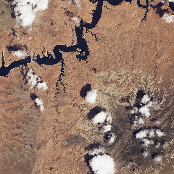
English: Natural-colour image of the Canyon Lands of Utah area, with Rainbow Bridge and Navajo Mountain (lower right).
|
| 日付 | |
| 原典 | NASA Earth Observatory |
| 作者 | Jesse Allen and Robert Simmon |
Image captured by the Advanced Land Imager (ALI) on NASA’s Earth Observing-1 (EO-1) satellite.
ライセンス
| このファイルはアメリカ航空宇宙局(NASA)によって作成されたものです。NASAの著作権の方針では、特記事項が無い場合、NASAの資料はパブリックドメインとなります。 (詳しくはTemplate:PD-USGov、NASAの著作権の方針について(英語)又はジェット推進研究所(JPL)の画像使用に関するガイドライン(英語)をご覧ください。) |
||
 |
注意事項:
|
| 注釈 | この画像には注釈がついています: コモンズで注釈を見る |
ファイルの履歴
過去の版のファイルを表示するには、その版の日時をクリックしてください。
| 日付と時刻 | サムネイル | 寸法 | 利用者 | コメント | |
|---|---|---|---|---|---|
| 現在の版 | 2010年5月30日 (日) 15:38 | | 2,000 × 2,000 (2.76メガバイト) | Originalwana | {{Information |Description={{en|1=Natural-colour image of the Rainbow Bridge area. Red, brown, and beige rocks predominate in this scene. In the past, the water level in [[:Category:Lake Powell |
ファイルの使用状況
以下のページがこのファイルを使用しています:
グローバルなファイル使用状況
以下に挙げる他のウィキがこの画像を使っています:
- en.wikipedia.org での使用状況
- hu.wikipedia.org での使用状況