
ファイル:Patagonia Snow.jpg

このプレビューのサイズ: 463 × 599 ピクセル。 その他の解像度: 185 × 240 ピクセル | 371 × 480 ピクセル | 850 × 1,100 ピクセル。
元のファイル (850 × 1,100 ピクセル、ファイルサイズ: 903キロバイト、MIME タイプ: image/jpeg)
ウィキメディア・コモンズのファイルページにある説明を、以下に表示します。
|
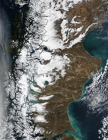
| 解説 | Snow runs down the spine of the Andes Mountains along the southern tip of South America. Chile is on the left, and Argentina is on the right. The water cutting across the continent in the bottom center of the image is the Strait of Magellan, once the only safe route between the Atlantic and the Pacific Oceans. Along the coast of Argentina, waters of the Atlantic Ocean are tinted green with sediment. |
| 日付 | |
| 原典 | http://visibleearth.nasa.gov/view_rec.php?id=6061 |
| 作者 | Jacques Descloitres, MODIS Rapid Response Team, NASA/GSFC |
| このファイルはアメリカ航空宇宙局(NASA)によって作成されたものです。NASAの著作権の方針では、特記事項が無い場合、NASAの資料はパブリックドメインとなります。 (詳しくはTemplate:PD-USGov、NASAの著作権の方針について(英語)又はジェット推進研究所(JPL)の画像使用に関するガイドライン(英語)をご覧ください。) |
||
 |
注意事項:
|
ファイルの履歴
過去の版のファイルを表示するには、その版の日時をクリックしてください。
| 日付と時刻 | サムネイル | 寸法 | 利用者 | コメント | |
|---|---|---|---|---|---|
| 現在の版 | 2017年10月30日 (月) 02:28 | | 850 × 1,100 (903キロバイト) | Janitoalevic | 1998 borders applied. |
| 2006年12月12日 (火) 04:16 |  | 850 × 1,100 (323キロバイト) | Mokono | An Image of the Ptatagonian winter Taken by the Nasa |
ファイルの使用状況
以下のページがこのファイルを使用しています:
グローバルなファイル使用状況
以下に挙げる他のウィキがこの画像を使っています:
- af.wikipedia.org での使用状況
- ca.wikipedia.org での使用状況
- de.wikipedia.org での使用状況
- el.wikipedia.org での使用状況
- es.wikipedia.org での使用状況
- it.wikipedia.org での使用状況
- lv.wikipedia.org での使用状況
- nn.wikipedia.org での使用状況
- pt.wikipedia.org での使用状況
- uk.wikipedia.org での使用状況
- zh.wikipedia.org での使用状況