
ファイル:PIA19420-Mercury-NorthHem-Topography-MLA-Messenger-20150416.jpg

元のファイル (3,750 × 3,752 ピクセル、ファイルサイズ: 3.49メガバイト、MIME タイプ: image/jpeg)
ウィキメディア・コモンズのファイルページにある説明を、以下に表示します。
|
概要
| 解説 |
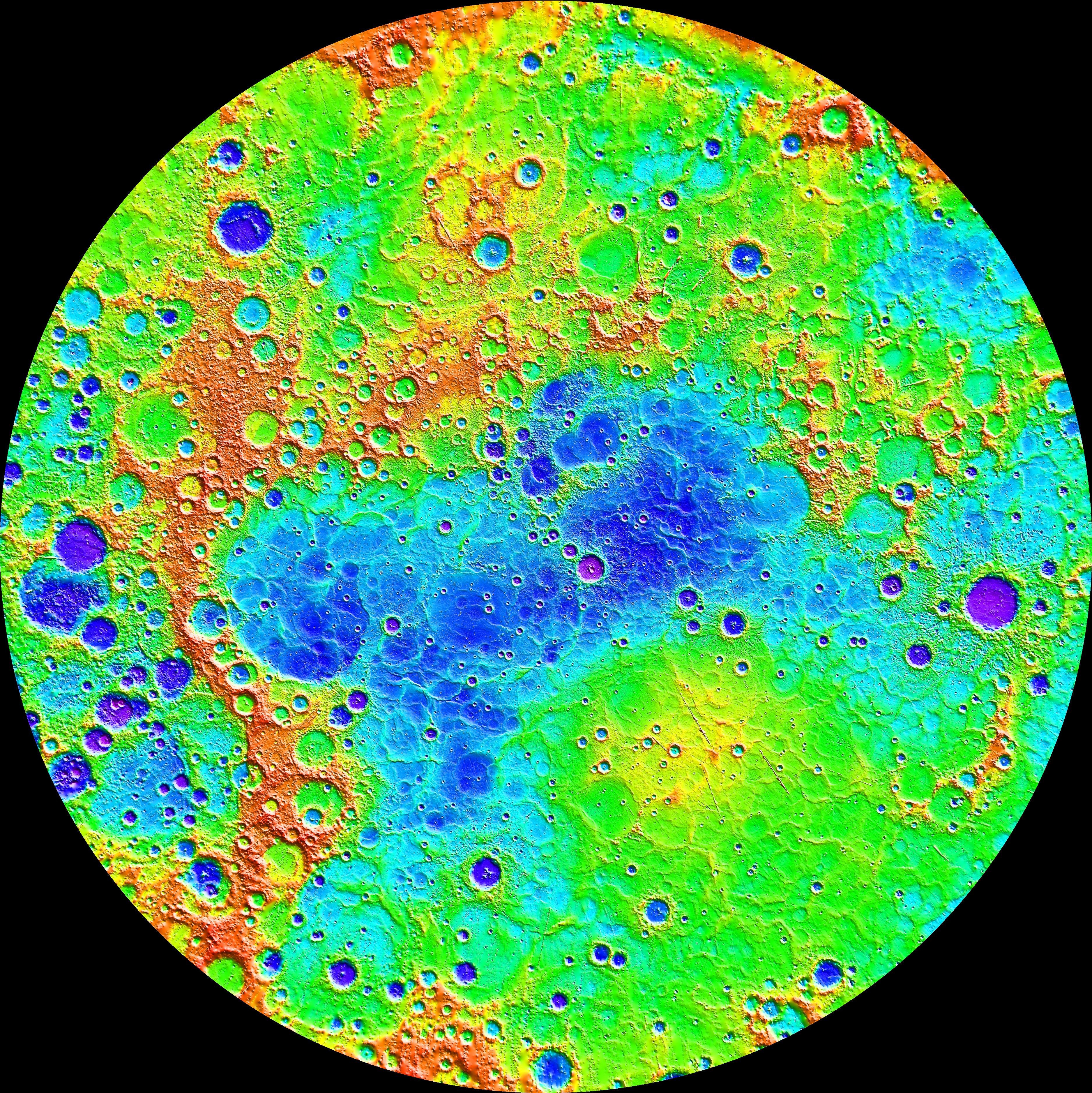
English: PIA19420: The Ups and Downs of Mercury's Topography
http://photojournal.jpl.nasa.gov/catalog/PIA19420 Measurements from MESSENGER's MLA instrument during the spacecraft's greater than four-year orbital mission have mapped the topography of Mercury's northern hemisphere in great detail. The view shown here is an interpolated shaded relief map of these data. The lowest regions are shown in purple, and the highest regions are shown in red. The difference in elevation between the lowest and highest regions shown here is roughly 10 kilometers! Among the prominent features visible here are the smooth northern volcanic plains and the enigmatic northern rise. The low-lying craters near the north pole host radar-bright materials, thought to be water ice. Linear artifacts can be seen in some areas of this map. These are due to individual MLA tracks that need minor adjustments in order to fit the rest of the data. Crossover analysis and better knowledge of the spacecraft position can be used to adjust these tracks and improve the map. Instrument: Mercury Laser Altimeter (MLA) Center Latitude: 90° Center Longitude: 0° E Latitude Range: 45° to 90° N The MESSENGER spacecraft is the first ever to orbit the planet Mercury, and the spacecraft's seven scientific instruments and radio science investigation are unraveling the history and evolution of the Solar System's innermost planet. In the mission's more than four years of orbital operations, MESSENGER has acquired over 250,000 images and extensive other data sets. MESSENGER's highly successful orbital mission is about to come to an end, as the spacecraft runs out of propellant and the force of solar gravity causes it to impact the surface of Mercury in April 2015. |
| 日付 | |
| 原典 | http://photojournal.jpl.nasa.gov/jpeg/PIA19420.jpg |
| 作者 | NASA/Johns Hopkins University Applied Physics Laboratory/Carnegie Institution of Washington |
ライセンス
| このファイルはアメリカ航空宇宙局(NASA)によって作成されたものです。NASAの著作権の方針では、特記事項が無い場合、NASAの資料はパブリックドメインとなります。 (詳しくはTemplate:PD-USGov、NASAの著作権の方針について(英語)又はジェット推進研究所(JPL)の画像使用に関するガイドライン(英語)をご覧ください。) |
||
 |
注意事項:
|
| 注釈 | この画像には注釈がついています: コモンズで注釈を見る |
ファイルの履歴
過去の版のファイルを表示するには、その版の日時をクリックしてください。
| 日付と時刻 | サムネイル | 寸法 | 利用者 | コメント | |
|---|---|---|---|---|---|
| 現在の版 | 2015年4月20日 (月) 12:56 | | 3,750 × 3,752 (3.49メガバイト) | Drbogdan | User created page with UploadWizard |
ファイルの使用状況
以下のページがこのファイルを使用しています:
グローバルなファイル使用状況
以下に挙げる他のウィキがこの画像を使っています:
- cs.wikipedia.org での使用状況
- en.wikipedia.org での使用状況
- en.wikiversity.org での使用状況
- et.wikipedia.org での使用状況
- eu.wikipedia.org での使用状況
- fr.wikipedia.org での使用状況
- it.wikipedia.org での使用状況
- mk.wikipedia.org での使用状況