
ファイル:PIA05484 modest.jpg
元のファイル (1,278 × 352 ピクセル、ファイルサイズ: 40キロバイト、MIME タイプ: image/jpeg)
ウィキメディア・コモンズのファイルページにある説明を、以下に表示します。
|
概要
| 解説 |
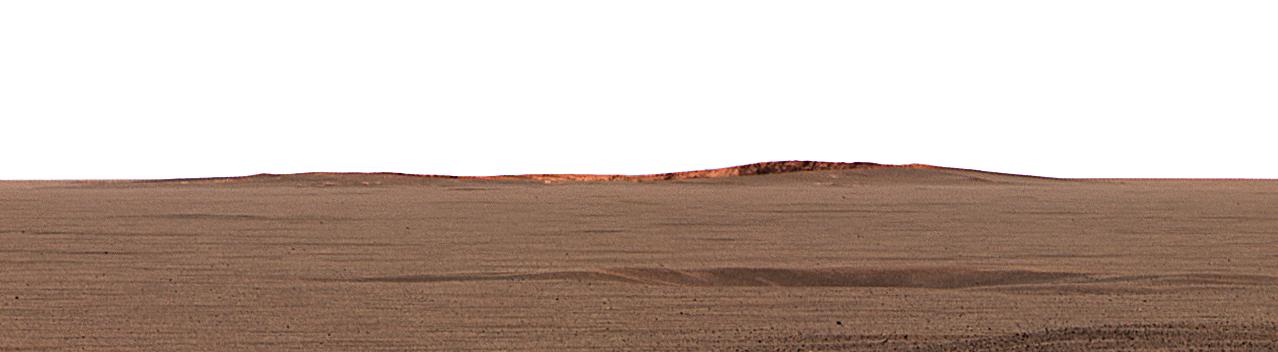
English: This image taken by the Mars Exploration Rover Opportunity's panoramic camera shows the eastern plains that stretch beyond the small crater where the rover landed. In the distance, the rim of a larger crater dubbed "Endurance" can be seen.
This color mosaic was taken on the 32nd martian day, or sol, of the rover's mission and spans 20 degrees of the horizon. It was taken while Opportunity was parked at the north end of the outcrop, in front of the rock region dubbed "El Capitan" and facing east. The features seen at the horizon are the near and far rims of "Endurance," the largest crater within about 6 kilometers (4 miles) of the lander. Using orbital data from the Mars Orbiter Camera on NASA's Mars Global Surveyor spacecraft, scientists estimated the crater to be 160 meters (175 yards) in diameter, and about 720 meters (half a mile) away from the lander. The highest point visible on "Endurance" is the highest point on the far wall of the crater; the sun is illuminating the inside of the far wall. Between the location where the image was taken at "El Capitan" and "Endurance" are the flat, smooth Meridiani plains, which scientists believe are blanketed in the iron-bearing mineral called hematite. The dark horizontal feature near the bottom of the picture is a small, five-meter (16-feet) crater, only 50 meters (164 feet) from Opportunity's present position. When the rover leaves the crater some 2 to 3 weeks from now, "Endurance" is one of several potential destinations. |
| 日付 | |
| 原典 | http://photojournal.jpl.nasa.gov/catalog/PIA05484 |
| 作者 | NASA/JPL/Cornell/MSSS |
| このタグは、添付された著作物の著作権状況を示すものではありません。通常の著作権タグも必要です。Commons:ライセンシングもご覧ください。 他言語での翻訳:
|
ライセンス
| このファイルはアメリカ航空宇宙局(NASA)によって作成されたものです。NASAの著作権の方針では、特記事項が無い場合、NASAの資料はパブリックドメインとなります。 (詳しくはTemplate:PD-USGov、NASAの著作権の方針について(英語)又はジェット推進研究所(JPL)の画像使用に関するガイドライン(英語)をご覧ください。) |
||
 |
注意事項:
|
元のアップロードログ
- 2004-03-02 23:38 Perl 1100×303× (28911 bytes) This image taken by the Mars Exploration Rover Opportunity's panoramic camera shows the eastern plains that stretch beyond the small crater where the rover landed. In the distance, the rim of a larger crater dubbed "Endurance" can be seen. This color m
ファイルの履歴
過去の版のファイルを表示するには、その版の日時をクリックしてください。
| 日付と時刻 | サムネイル | 寸法 | 利用者 | コメント | |
|---|---|---|---|---|---|
| 現在の版 | 2013年2月17日 (日) 04:53 | 1,278 × 352 (40キロバイト) | Huntster | Full size from original source. | |
| 2009年5月28日 (木) 22:51 | 1,100 × 303 (28キロバイト) | File Upload Bot (Magnus Manske) | {{BotMoveToCommons|en.wikipedia|year={{subst:CURRENTYEAR}}|month={{subst:CURRENTMONTHNAME}}|day={{subst:CURRENTDAY}}}} {{Information |Description={{en|This image taken by the Mars Exploration Rover Opportunity's panoramic camera shows the eastern plains |
ファイルの使用状況
以下のページがこのファイルを使用しています:
グローバルなファイル使用状況
以下に挙げる他のウィキがこの画像を使っています:
- en.wikipedia.org での使用状況
- fa.wikipedia.org での使用状況
- fr.wikipedia.org での使用状況
- hr.wikipedia.org での使用状況
- no.wikipedia.org での使用状況
- ru.wikipedia.org での使用状況
- sv.wikipedia.org での使用状況
- uk.wikipedia.org での使用状況
- zh.wikipedia.org での使用状況