
ファイル:Oslo Metro map.svg

この SVG ファイルのこの PNG プレビューのサイズ: 800 × 489 ピクセル. その他の解像度: 320 × 196 ピクセル | 640 × 391 ピクセル | 1,024 × 626 ピクセル | 1,280 × 782 ピクセル | 2,560 × 1,564 ピクセル | 1,586 × 969 ピクセル。
元のファイル (SVG ファイル、1,586 × 969 ピクセル、ファイルサイズ: 69キロバイト)
ウィキメディア・コモンズのファイルページにある説明を、以下に表示します。
|
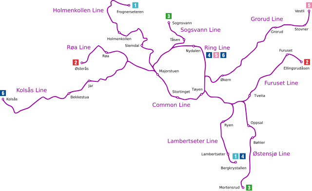
| 解説 | Diagram of the Oslo Metro |
| 日付 | (UTC) |
| 原典 | |
| 作者 |
|
このファイルはクリエイティブ・コモンズ 表示-継承 3.0 非移植ライセンスのもとに利用を許諾されています。
- あなたは以下の条件に従う場合に限り、自由に
- 共有 – 本作品を複製、頒布、展示、実演できます。
- 再構成 – 二次的著作物を作成できます。
- あなたの従うべき条件は以下の通りです。
- 表示 – あなたは適切なクレジットを表示し、ライセンスへのリンクを提供し、変更があったらその旨を示さなければなりません。これらは合理的であればどのような方法で行っても構いませんが、許諾者があなたやあなたの利用行為を支持していると示唆するような方法は除きます。
- 継承 – もしあなたがこの作品をリミックスしたり、改変したり、加工した場合には、あなたはあなたの貢献部分を元の作品とこれと同一または互換性があるライセンスの下に頒布しなければなりません。
元のアップロードログ
This image is a derivative work of the following images:
- File:Tbane_geogr.gif licensed with PD-self
Uploaded with derivativeFX
ファイルの履歴
過去の版のファイルを表示するには、その版の日時をクリックしてください。
| 日付と時刻 | サムネイル | 寸法 | 利用者 | コメント | |
|---|---|---|---|---|---|
| 現在の版 | 2009年11月18日 (水) 23:10 | | 1,586 × 969 (69キロバイト) | Arsenikk | Move "Ring Line" and 4/5/6 to make it clear they do not terminate at Nydalen |
| 2009年11月18日 (水) 11:10 |  | 1,586 × 969 (67キロバイト) | Tryphon | Trying to remove the black line. | |
| 2009年11月18日 (水) 00:39 |  | 1,586 × 969 (81キロバイト) | Arsenikk | {{Information |Description=Diagram of the Oslo Metro |Source=*File:Tbane_geogr.gif |Date=2009-11-18 00:36 (UTC) |Author=*File:Tbane_geogr.gif: Pneumaman *derivative work: ~~~ |Permission=see below |other_ve |
ファイルの使用状況
以下のページがこのファイルを使用しています:
グローバルなファイル使用状況
以下に挙げる他のウィキがこの画像を使っています:
- en.wikipedia.org での使用状況
- zh.wikipedia.org での使用状況