
ファイル:Near east lrg.jpg

このプレビューのサイズ: 451 × 599 ピクセル。 その他の解像度: 181 × 240 ピクセル | 361 × 480 ピクセル | 578 × 768 ピクセル | 771 × 1,024 ピクセル | 1,542 × 2,048 ピクセル | 2,987 × 3,967 ピクセル。
元のファイル (2,987 × 3,967 ピクセル、ファイルサイズ: 2.62メガバイト、MIME タイプ: image/jpeg)
ウィキメディア・コモンズのファイルページにある説明を、以下に表示します。
|
| 解説 |
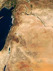
This true-color image of the region was taken on September 10, 2000, by the MODerate-resolution Imaging Spectroradiometer (MODIS) flying aboard NASA's Terra spacecraft. The image shows the lands of Israel along the eastern shore of the Mediterranean Sea, with the countries of Jordan to the southeast and Syria to the Northeast. The region known as the West Bank lies between the two countries. Running from north to south, the Jordan River links the Sea of Galilee to the Dead Sea. Click the image to enlarge it, and to see the borders drawn in. Image courtesy Jacques Descloitres, MODIS Land Group, NASA GSFC |
| 日付 | image taken on 10. Sep. 2000 |
| 原典 | http://earthobservatory.nasa.gov/Newsroom/NewImages/Images/modis_near_east_lrg.jpg |
| 作者 | NASA, earthobservatory, http://earthobservatory.nasa.gov/ |
| 許可 (ファイルの再利用) |
PD-USGov-NASA |
| このファイルはアメリカ航空宇宙局(NASA)によって作成されたものです。NASAの著作権の方針では、特記事項が無い場合、NASAの資料はパブリックドメインとなります。 (詳しくはTemplate:PD-USGov、NASAの著作権の方針について(英語)又はジェット推進研究所(JPL)の画像使用に関するガイドライン(英語)をご覧ください。) |
||
 |
注意事項:
|
ファイルの履歴
過去の版のファイルを表示するには、その版の日時をクリックしてください。
| 日付と時刻 | サムネイル | 寸法 | 利用者 | コメント | |
|---|---|---|---|---|---|
| 現在の版 | 2015年2月5日 (木) 20:27 | | 2,987 × 3,967 (2.62メガバイト) | Capricorn4049 | Cropped < 1 % horizontally and 1 % vertically using CropTool with precise mode. |
| 2005年6月5日 (日) 09:29 |  | 3,002 × 4,002 (1.96メガバイト) | Prolineserver | near east, PD-USGov-NASA |
ファイルの使用状況
以下のページがこのファイルを使用しています:
グローバルなファイル使用状況
以下に挙げる他のウィキがこの画像を使っています:
- ar.wikipedia.org での使用状況
- arz.wikipedia.org での使用状況
- ast.wikipedia.org での使用状況
- ba.wikipedia.org での使用状況
- ca.wikipedia.org での使用状況
- ckb.wikipedia.org での使用状況
- el.wikipedia.org での使用状況
- en.wikipedia.org での使用状況
- eo.wikipedia.org での使用状況
- eo.wikiquote.org での使用状況
- es.wikipedia.org での使用状況
- eu.wikipedia.org での使用状況
- fa.wikipedia.org での使用状況
- fr.wikipedia.org での使用状況
- gl.wikipedia.org での使用状況
- he.wikipedia.org での使用状況
- id.wikipedia.org での使用状況
- is.wikipedia.org での使用状況
- it.wikipedia.org での使用状況
- kbp.wikipedia.org での使用状況
- ko.wikipedia.org での使用状況
- mk.wikipedia.org での使用状況
このファイルのグローバル使用状況を表示する。