
ファイル:Mojave Desert, Tehachapi Mountains, and San Joaquin Valley (California) – satellite image.jpg

このプレビューのサイズ: 800 × 484 ピクセル。 その他の解像度: 320 × 194 ピクセル | 640 × 387 ピクセル | 1,024 × 619 ピクセル | 1,280 × 774 ピクセル | 2,560 × 1,548 ピクセル | 8,824 × 5,336 ピクセル。
元のファイル (8,824 × 5,336 ピクセル、ファイルサイズ: 13.03メガバイト、MIME タイプ: image/jpeg)
ウィキメディア・コモンズのファイルページにある説明を、以下に表示します。
|
概要
| 解説 |
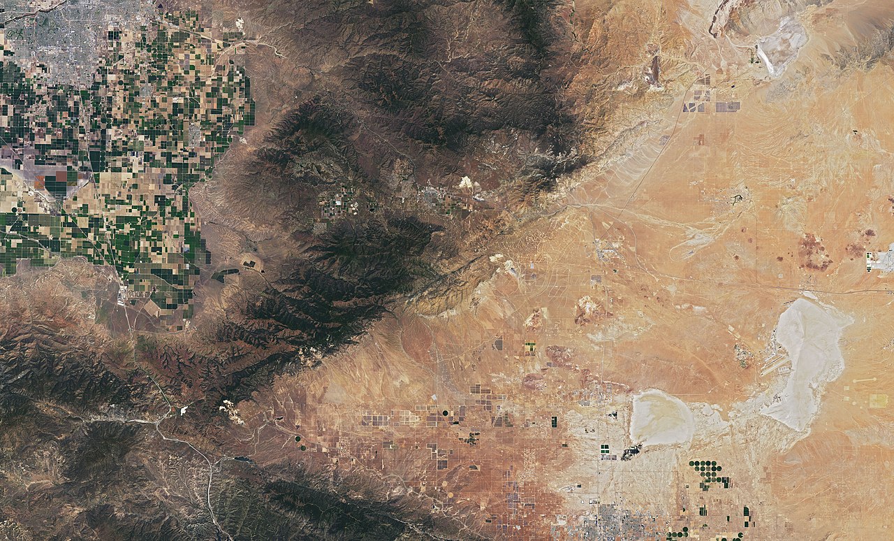
English: Satellite image of Mojave Desert (right), Tehachapi Mountains (Transverse Ranges) (center) and the southermost part of San Joaquin Valley (top left) in California. Mostly Kern County, the southermost part Los Angeles County.
On July 1, 2019, Operational Land Imager (OLI) on NASA's Landsat 8 acquired this image. Well visible landmarks: Bakersfield and the farmlands of San Joaquin Valley (top left). Tehachapi Pass (center). To the right of it, a massive amount of wind turbines (mostly Alta Wind Energy Center, one of the biggest wind farms in the world), which are connected by both straight and sinuous access roads. Rogers Dry Lake (bottom right) with Edwards Air Force Base, where the first Space Shuttle landed (then back-up landing site to Kennedy Space Center, Florida). |
| 日付 | |
| 原典 | https://earthobservatory.nasa.gov/images/145607/cameron-ridge?src=ve |
| 作者 | NASA |
_%E2%80%93_satellite_image.jpg)

,_California_%E2%80%93_satellite_image.jpg)


_%E2%80%93_satellite_image.jpg?uselang=ja)
_%E2%80%93_satellite_image.jpg?uselang=ja)
_%E2%80%93_satellite_image.jpg?uselang=ja&action=history)
_%E2%80%93_satellite_image.jpg)
,_California_%E2%80%93_satellite_image.jpg)
_California_%E2%80%93_labeled_satellite_image.png)
ライセンス
| このファイルはアメリカ航空宇宙局(NASA)によって作成されたものです。NASAの著作権の方針では、特記事項が無い場合、NASAの資料はパブリックドメインとなります。 (詳しくはTemplate:PD-USGov、NASAの著作権の方針について(英語)又はジェット推進研究所(JPL)の画像使用に関するガイドライン(英語)をご覧ください。) |
||
 |
注意事項:
|
ファイルの履歴
過去の版のファイルを表示するには、その版の日時をクリックしてください。
| 日付と時刻 | サムネイル | 寸法 | 利用者 | コメント | |
|---|---|---|---|---|---|
| 現在の版 | 2019年10月12日 (土) 21:08 | | 8,824 × 5,336 (13.03メガバイト) | A11w1ss3nd | {{Information |description ={{en|1=Satellite image of Mojave Desert (right), Tehachapi Mountains (Transverse Ranges) (center) and the southermost part of San Joaquin Valley (top left) in California. Mostly Kern County, the southermost part Los Angeles County. On July 1, 2019, Operational Land Imager (OLI) on NASA's Landsat 8 acquired this image. Well visible landmarks: Bakersfield and the farmlands of San Joaquin Valley (top left). Tehachapi Pass (center). To the right of it, a massive... |
ファイルの使用状況
このファイルを使用しているページはありません。
_–_satellite_image.jpg)