
ファイル:Mississippi-Coast-towns-NOAA.jpg
高解像度版はありません。
Mississippi-Coast-towns-NOAA.jpg (750 × 382 ピクセル、ファイルサイズ: 57キロバイト、MIME タイプ: image/jpeg)
ウィキメディア・コモンズのファイルページにある説明を、以下に表示します。
|

|
この地図画像は、ベクターイメージである SVG ファイルとして再作成されるべきです。これにはいくつかの利点があります。詳しくはCommons:Media for cleanupを参照してください。この画像の SVG 形式がすでに利用可能である場合は、アップロードしてください。アップロード後、この画像にあるこのテンプレートを{{Vector version available|新しい画像ファイル名.svg}}テンプレートで置き換えてください。
|


概要
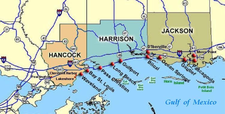
| 解説 | Coastal map of the U.S. state of Mississippi, showing major towns and cities in the three coastal counties: Hancock, Harrison, and Jackson County. Also shown are Cat Island, West Ship Island, East Ship Island, Horn Island and Petit Bois Island.The locations of towns, roads and offshore islands are based on NOAA and NASA maps. |
| 日付 | |
| 原典 |
投稿者自身による著作物; self-made (hand-edited with MS-Paint)
Pure stupidity: The map is in quick JPEG format, for large display as highly readable, in about 20 articles that display the map. JPEG clarity is enhanced by painted areas behind many labels, causing the wording to be clearer than even a massive SVG or PNG-format file could provide, due to the sharp display contrast of JPEG files. JPEG Clarity: Even though JPEG images have artifacts, they can display clearer wording in small maps due to auto-contrast enhancement. The same painted/shaded areas, that illuminate wording, would make the map excessively gargantuan in slow cumbersome PNG or SVG format, as is the case with terrain maps, which also should NEVER be converted to massive PNG format. |
| 作者 | Wikid77 |
ライセンス
| この著作物は、著作者であるI, Wikid77によって権利が放棄され、パブリックドメインとされました。これは全世界で適用されます。 一部の国では、これが法的に可能ではない場合があります。その場合は、次のように宣言します。 I, Wikid77は、あらゆる人に対して、法により必要とされている条件を除き、如何なる条件も課すことなく、あらゆる目的のためにこの著作物を使用する権利を与えます。 |
ファイルの履歴
過去の版のファイルを表示するには、その版の日時をクリックしてください。
| 日付と時刻 | サムネイル | 寸法 | 利用者 | コメント | |
|---|---|---|---|---|---|
| 現在の版 | 2007年6月26日 (火) 02:54 | | 750 × 382 (57キロバイト) | Wikid77 | Brown-toned map: Hancock County as tan (was green); put "Gulf of Mexico" Antigua font; shift labels on islands |
| 2007年6月26日 (火) 00:17 |  | 750 × 382 (56キロバイト) | Wikid77 | Mississippi coastal map, with "Horn Island" relabeled, clarified Hwy "90" and "63" icons. | |
| 2007年6月21日 (木) 18:56 |  | 750 × 382 (56キロバイト) | Wikid77 | re-load of image file, in case internal data was garbled | |
| 2007年6月21日 (木) 18:11 |  | 750 × 382 (56キロバイト) | Wikid77 | {{Information |Description=Coastal map of the U.S. state of en:Mississippi, showing major towns and cities in the 3 coastal counties: Hancock, Harrison, a |
ファイルの使用状況
以下の 8 ページがこのファイルを使用しています:
グローバルなファイル使用状況
以下に挙げる他のウィキがこの画像を使っています:
- ca.wikipedia.org での使用状況
- de.wikipedia.org での使用状況
- en.wikipedia.org での使用状況
- Hancock County, Mississippi
- Pearlington, Mississippi
- Waveland, Mississippi
- Biloxi, Mississippi
- Gulfport, Mississippi
- Long Beach, Mississippi
- Gautier, Mississippi
- Ocean Springs, Mississippi
- Pascagoula Abduction
- Effects of Hurricane Katrina in Mississippi
- Ship Island
- Horn Island Chemical Warfare Service Quarantine Station
- fr.wikipedia.org での使用状況
- fy.wikipedia.org での使用状況
- he.wikipedia.org での使用状況
- hu.wikipedia.org での使用状況
- it.wikipedia.org での使用状況
- pt.wikipedia.org での使用状況
- tr.wikipedia.org での使用状況
- vi.wikipedia.org での使用状況
- zh.wikipedia.org での使用状況