
ファイル:Mecklenburg-Vorpommern Map Districts Border Mecklenburg Western Pomerania - Landkreise Grenzen Karte MV MeckPomm.svg

この SVG ファイルのこの PNG プレビューのサイズ: 800 × 549 ピクセル. その他の解像度: 320 × 220 ピクセル | 640 × 439 ピクセル | 1,024 × 703 ピクセル | 1,280 × 879 ピクセル | 2,560 × 1,757 ピクセル | 1,129 × 775 ピクセル。
元のファイル (SVG ファイル、1,129 × 775 ピクセル、ファイルサイズ: 759キロバイト)
ウィキメディア・コモンズのファイルページにある説明を、以下に表示します。
|
概要
| 解説 |
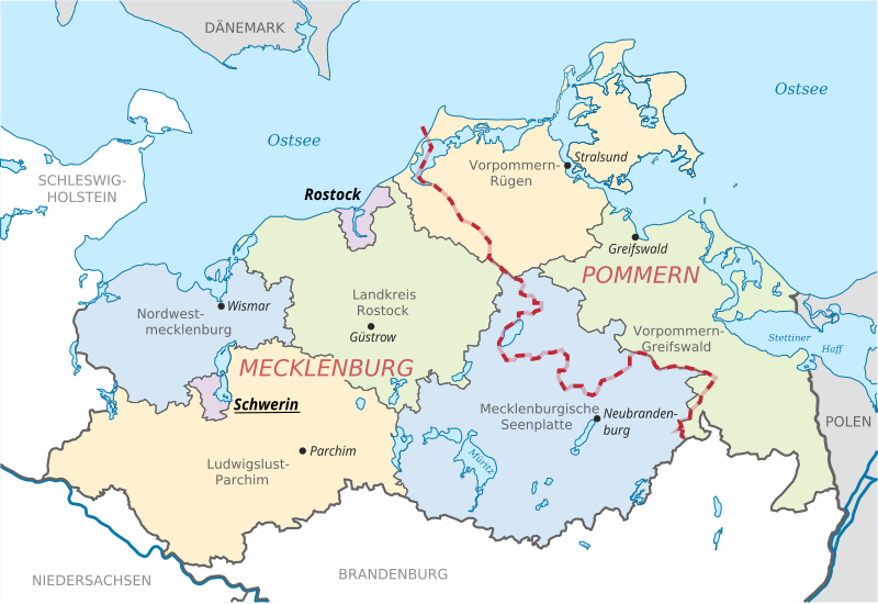
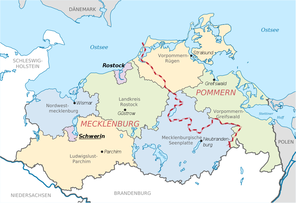
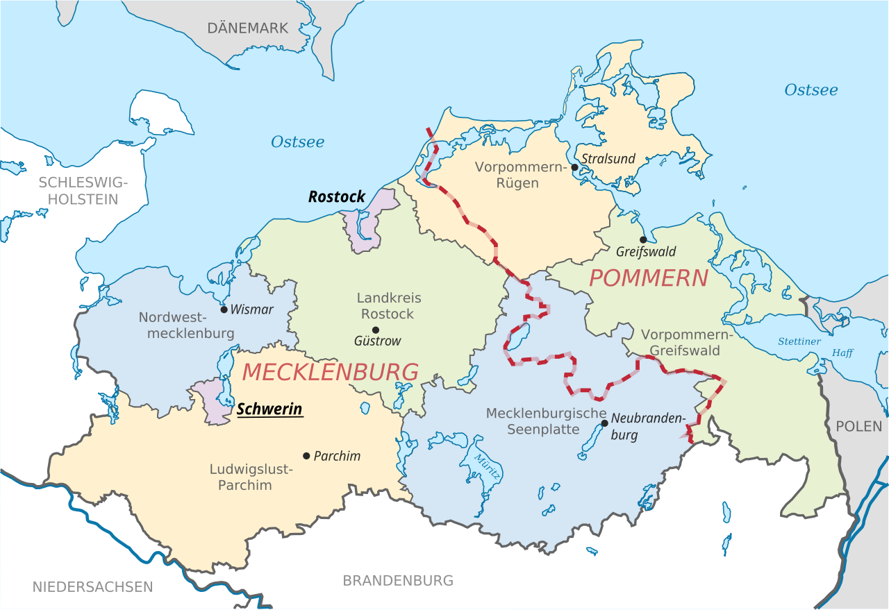
English: Locator map of counties and their seats in Mecklenburg-Vorpommern, Germany after county reorganization 2011. The red-white line indicates the former border between the state of Mecklenburg and the Prussian province of Pommerania.
Deutsch: Karte mit Lage der Landkreise und Kreisstädte in Mecklenburg-Vorpommern, Deutschland nach der Kreisgebietsreform 2011. Eingezeichnet ist auch die Grenze zwischen dem früheren Staat Mecklenburg und der preußischen Provinz Pommern. |
| 日付 | |
| 原典 | File:Mecklenburg-Vorpommern districts 2011 colored labeled Meck-Pomm-border.svg |
| 作者 | TUBS |
| その他のバージョン |
|


ライセンス
| この著作物は、著作者であるTUBSによって権利が放棄され、パブリックドメインとされました。これは全世界で適用されます。 一部の国では、これが法的に可能ではない場合があります。その場合は、次のように宣言します。 |
ファイルの履歴
過去の版のファイルを表示するには、その版の日時をクリックしてください。
| 日付と時刻 | サムネイル | 寸法 | 利用者 | コメント | |
|---|---|---|---|---|---|
| 現在の版 | 2014年6月16日 (月) 11:51 | | 1,129 × 775 (759キロバイト) | Horst-schlaemma | {{Information |Description ={{en|1=Locator map of counties and their seats in Mecklenburg-Vorpommern, Germany after county reorganization 2011. The red-white line indicates the former borders of the his... |
ファイルの使用状況
以下の 2 ページがこのファイルを使用しています:
グローバルなファイル使用状況
以下に挙げる他のウィキがこの画像を使っています:
- af.wikipedia.org での使用状況
- als.wikipedia.org での使用状況
- an.wikipedia.org での使用状況
- ast.wikipedia.org での使用状況
- ay.wikipedia.org での使用状況
- az.wikipedia.org での使用状況
- ba.wikipedia.org での使用状況
- be-tarask.wikipedia.org での使用状況
- bg.wikipedia.org での使用状況
- br.wikipedia.org での使用状況
- ca.wikipedia.org での使用状況
- csb.wikipedia.org での使用状況
- cs.wikipedia.org での使用状況
- cy.wikipedia.org での使用状況
- de.wikipedia.org での使用状況
- de.wikivoyage.org での使用状況
- dsb.wikipedia.org での使用状況
- en.wikipedia.org での使用状況
- eo.wikipedia.org での使用状況
- es.wikipedia.org での使用状況
- et.wikipedia.org での使用状況
- eu.wikipedia.org での使用状況
- fi.wikipedia.org での使用状況
- frr.wikipedia.org での使用状況
- fr.wikipedia.org での使用状況
- fy.wikipedia.org での使用状況
- ga.wikipedia.org での使用状況
- gd.wikipedia.org での使用状況
- gl.wikipedia.org での使用状況
- gn.wikipedia.org での使用状況
- gv.wikipedia.org での使用状況
- he.wikipedia.org での使用状況
- hr.wikipedia.org での使用状況
- hsb.wikipedia.org での使用状況
- hu.wikipedia.org での使用状況
- hu.wiktionary.org での使用状況
- ia.wikipedia.org での使用状況
- id.wikipedia.org での使用状況
このファイルのグローバル使用状況を表示する。