
ファイル:Mars Viking 22a002.png

このプレビューのサイズ: 800 × 156 ピクセル。 その他の解像度: 320 × 62 ピクセル | 640 × 125 ピクセル | 2,626 × 512 ピクセル。
元のファイル (2,626 × 512 ピクセル、ファイルサイズ: 361キロバイト、MIME タイプ: image/png)
ウィキメディア・コモンズのファイルページにある説明を、以下に表示します。
|
概要
| 解説 |
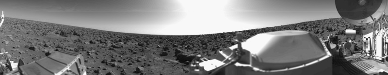
English: Original Caption Released with NASA Image: This rocky panoramic scene is the second picture of the Martian surface that was taken by Viking Lander 2 shortly after touchdown on September 3 at 3:58 PM PDT (Earth received time). The site is on a northern plain of Mars, at about 48 N. Lat., 226 W. Long., known as Utopia Planitia. The picture sweeps around 330 degrees in azimuth, starting from northwest at the left through north (above the sampler arm housing) past east, where the sky is bright at the center, and southeast toward the right above the radioisotope thermoelectric generator cover. The surface is strewn with rocks out to the horizon, ranging in size up to several meters across. Some pitted rocks resemble fragments of porous volcanic lava. Other rocks have grooves that may have been eroded by windblown sand and dust. Although fine-grained material is seen between the boulders, no sand dunes are evident. The dip in the eastern horizon at the center is an illusion caused by an 8-degree tilt of the Lander toward the west. Actually, the terrain is more level than that at the Viking 1 site. The horizon toward the left of the panorama (northwest) appears featureless, indicating that it may be several kilometers distant. The sky at the center (east) is bright because the sun was above but out of the picture at 10 AM Mars time. Toward the right (southeast), the rocks that are silhouetted against the skyline indicate that the horizon is much nearer, probably because of a slight rise in that area of the terrain. The circular high-gain antenna at the right has clots of fine-grained material adhering to the lower half, some of which appeared to have been sliding downward while the camera was scanning the area. At the extreme right, the banded appearance resulted because the camera continued to scan while it was no longer moving in azimuth. Any motion or other variation in the scene would show up as a change in successive lines. |
| 日付 | 2010-02-17; original photo was taken 1977-09-03. |
| 原典 | Own work based on images in the NASA Viking image archive |
| 作者 | "Roel van der Hoorn (Van der Hoorn)" |
| 許可 (ファイルの再利用) |
I used the original 22a002.sur image from the NASA Viking image archive, converted it to .png and manually removed the noise. Except for the conversion, this was done in Adobe Photoshop CS2 and Adobe Photoshop CS4. The original file by NASA is in the public domain, and so is this new one. |
| その他のバージョン | I created this image as a replacement for the File:Vl2.jpg. This file was created by NASA, but the quality is not very high, especially on the right side. Using the original pictures from the Lander archive resulted in a higher quality image. |
ライセンス
| この著作物は、著作者である英語版ウィキペディアのVan der Hoornさんによって権利が放棄され、パブリックドメインとされました。これは全世界で適用されます。 一部の国では、これが法的に可能ではない場合があります。その場合は、次のように宣言します。 Van der Hoornは、あらゆる人に対して、法により必要とされている条件を除き、如何なる条件も課すことなく、あらゆる目的のためにこの著作物を使用する権利を与えます。 |
The image is based on an original image from NASA to which the following copyright statement is applicable:
| このファイルはアメリカ航空宇宙局(NASA)によって作成されたものです。NASAの著作権の方針では、特記事項が無い場合、NASAの資料はパブリックドメインとなります。 (詳しくはTemplate:PD-USGov、NASAの著作権の方針について(英語)又はジェット推進研究所(JPL)の画像使用に関するガイドライン(英語)をご覧ください。) |
||
 |
注意事項:
|
ファイルの履歴
過去の版のファイルを表示するには、その版の日時をクリックしてください。
| 日付と時刻 | サムネイル | 寸法 | 利用者 | コメント | |
|---|---|---|---|---|---|
| 現在の版 | 2010年2月17日 (水) 00:31 | 2,626 × 512 (361キロバイト) | Van der Hoorn | {{Information |Description={{en|1='''Original Caption Released with NASA Image:'''<br />This rocky panoramic scene is the second picture of the Martian surface that was taken by Viking Lander 2 shortly after touchdown on September 3 at 3:58 PM PDT (Earth |
ファイルの使用状況
以下の 2 ページがこのファイルを使用しています:
グローバルなファイル使用状況
以下に挙げる他のウィキがこの画像を使っています:
- ca.wikipedia.org での使用状況
- de.wikipedia.org での使用状況
- en.wikipedia.org での使用状況
- es.wikipedia.org での使用状況
- fr.wikipedia.org での使用状況
- he.wikipedia.org での使用状況
- it.wikipedia.org での使用状況
- kk.wikipedia.org での使用状況
- lmo.wikipedia.org での使用状況
- lt.wikipedia.org での使用状況
- ru.wikipedia.org での使用状況
- uk.wikipedia.org での使用状況
- vi.wikipedia.org での使用状況
- zh.wikipedia.org での使用状況