
ファイル:Map of Mimas 2010-02 PIA12780.jpg

このプレビューのサイズ: 800 × 475 ピクセル。 その他の解像度: 320 × 190 ピクセル | 640 × 380 ピクセル | 1,024 × 608 ピクセル | 1,280 × 760 ピクセル | 2,560 × 1,519 ピクセル | 6,330 × 3,756 ピクセル。
元のファイル (6,330 × 3,756 ピクセル、ファイルサイズ: 3.64メガバイト、MIME タイプ: image/jpeg)
ウィキメディア・コモンズのファイルページにある説明を、以下に表示します。
|
概要
| 解説 |
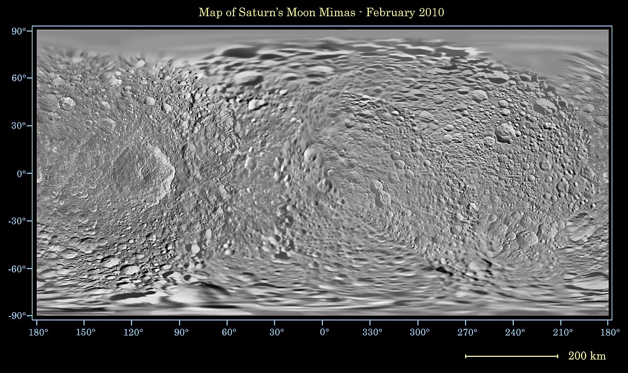
English: This global map of Saturn's moon Mimas was created using images taken during Cassini spacecraft flybys, with Voyager images filling in the gaps in Cassini's coverage.
The moon's large, distinguishing crater, Herschel, is seen on the map at left. The map is an equidistant (simple cylindrical) projection and has a scale of 216 meters (710 feet) per pixel at the equator. The mean radius of Mimas used for projection of this map is 198.2 kilometers (123.2 miles). The resolution of the map is 16 pixels per degree. This mosaic map is an update to the version released in June 2008 (See PIA11118). |
| 日付 | |
| 原典 | http://www.ciclops.org/view_media/31726/Map_of_Mimas_-_February_2010 |
| 作者 | NASA/JPL/Space Science Institute |
| このタグは、添付された著作物の著作権状況を示すものではありません。通常の著作権タグも必要です。Commons:ライセンシングもご覧ください。 他言語での翻訳:
|
ライセンス
| このファイルはアメリカ航空宇宙局(NASA)によって作成されたものです。NASAの著作権の方針では、特記事項が無い場合、NASAの資料はパブリックドメインとなります。 (詳しくはTemplate:PD-USGov、NASAの著作権の方針について(英語)又はジェット推進研究所(JPL)の画像使用に関するガイドライン(英語)をご覧ください。) |
||
 |
注意事項:
|
ファイルの履歴
過去の版のファイルを表示するには、その版の日時をクリックしてください。
| 日付と時刻 | サムネイル | 寸法 | 利用者 | コメント | |
|---|---|---|---|---|---|
| 現在の版 | 2011年1月18日 (火) 07:46 | | 6,330 × 3,756 (3.64メガバイト) | Bryan Derksen | {{Information |Description={{en|1=This global map of Saturn's moon Mimas was created using images taken during Cassini spacecraft flybys, with Voyager images filling in the gaps in Cassini's coverage. The moon's large, distinguishing crater, Herschel, is |
ファイルの使用状況
以下のページがこのファイルを使用しています:
グローバルなファイル使用状況
以下に挙げる他のウィキがこの画像を使っています:
- de.wikipedia.org での使用状況
- gl.wikipedia.org での使用状況
- hi.wikipedia.org での使用状況
- lb.wikipedia.org での使用状況
- pl.wikipedia.org での使用状況
- sv.wikipedia.org での使用状況
- uk.wikipedia.org での使用状況