
ファイル:Kaloum Peninsula 2000.jpg

このプレビューのサイズ: 800 × 600 ピクセル。 その他の解像度: 320 × 240 ピクセル | 640 × 480 ピクセル | 1,024 × 768 ピクセル | 1,280 × 960 ピクセル | 2,000 × 1,500 ピクセル。
元のファイル (2,000 × 1,500 ピクセル、ファイルサイズ: 4.47メガバイト、MIME タイプ: image/jpeg)
ウィキメディア・コモンズのファイルページにある説明を、以下に表示します。
|
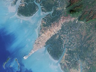
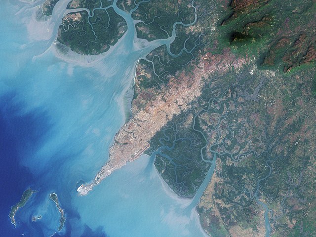
| 解説 | The city of Conakry, Guinea, originated on Tombo Island and spread up the Kaloum Peninsula, sandwiched between mangrove swamps. In the 1960s, the city had a population of fewer than 40,000; in 2006, it had a population of nearly 2 million. These natural-color images, acquired by NASA’s Landsat satellites, show the city’s dramatic growth from 1986 to 2000. Land and water features look similar to how they would look in a photograph by a digital camera. Water ranges in color from deep to pale blue, vegetation appears dark green, and bare ground and urbanized areas range in color from gray to beige to reddish-brown. | |||||
| 日付 | ||||||
| 原典 | Earth Observatory | |||||
| 作者 | NASA image created by Jesse Allen, using Landsat data provided by the United States Geological Survey. Landsat 7 | |||||
| 許可 (ファイルの再利用) |
|
|||||
| その他のバージョン |
 |

ファイルの履歴
過去の版のファイルを表示するには、その版の日時をクリックしてください。
| 日付と時刻 | サムネイル | 寸法 | 利用者 | コメント | |
|---|---|---|---|---|---|
| 現在の版 | 2008年7月19日 (土) 17:45 | | 2,000 × 1,500 (4.47メガバイト) | CarolSpears | {{Information |Description=The city of Conakry, Guinea, originated on Tombo Island and spread up the Kaloum Peninsula, sandwiched between mangrove swamps. In the 1960s, the city had a population of fewer than 40,000; in 2006, it had a population of nearly |
ファイルの使用状況
以下のページがこのファイルを使用しています:
グローバルなファイル使用状況
以下に挙げる他のウィキがこの画像を使っています:
- ar.wikipedia.org での使用状況
- arz.wikipedia.org での使用状況
- be.wikipedia.org での使用状況
- ca.wikipedia.org での使用状況
- ceb.wikipedia.org での使用状況
- cv.wikipedia.org での使用状況
- de.wikipedia.org での使用状況
- el.wikipedia.org での使用状況
- en.wikipedia.org での使用状況
- es.wikipedia.org での使用状況
- eu.wikipedia.org での使用状況
- fi.wikipedia.org での使用状況
- fr.wikipedia.org での使用状況
- ha.wikipedia.org での使用状況
- nqo.wikipedia.org での使用状況
- pl.wikipedia.org での使用状況
- ru.wikipedia.org での使用状況
- sv.wikipedia.org での使用状況
- www.wikidata.org での使用状況