
ファイル:ISS-052-E006364 (Presque Isle Bay and Erie) lrg.jpg

元のファイル (4,928 × 3,280 ピクセル、ファイルサイズ: 9.78メガバイト、MIME タイプ: image/jpeg)
ウィキメディア・コモンズのファイルページにある説明を、以下に表示します。
|
_lrg.jpg?uselang=ja)
_lrg.jpg?uselang=ja)
_lrg.jpg?uselang=ja&action=history)
_lrg.jpg)
概要
| 解説 |
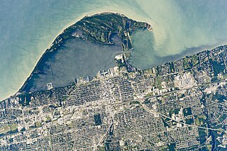
English: An astronaut aboard the International Space Station focused a long-lens camera on the southern coastline of Lake Erie. The curved peninsula of Presque Isle State Park juts into the Great Lake, while the city in the lower part of the image is the deep-water port of Erie, Pennsylvania. Several V-shaped wakes show boat traffic around the port.
The lake water just offshore tends to be light-toned because significant river and beach sediment is regularly moved eastward by the action of wind and waves. The detailed image shows the swells made by these winds. Sediment has piled up to build this sand spit over thousands of years. Now covered with vegetation, Presque Isle State Park includes dozens of beach ridges—with each line representing a coastline from the past. The formation of the peninsula also has enclosed Presque Isle Bay, the site of modern port facilities. Because the sediment is constantly moved along the shore by waves, the exposed beach facing the lake has been protected from erosion. To do this, many short breakwaters (barriers) have been built just offshore for nearly the entire length of the beach.Deutsch: Ein Astronaut an Bord der Internationalen Raumstation richtete eine Kamera mit langer Brennweie auf die südliche Küstenlinie des Eriesee. Die mondsicherförmige Halbinsel des Presque Isle State Park ragt in den See hinein, während die Stadt mit Tiefwasserhafen im unteren Teil des Bildes Erie, Pennsylvania ist. Mehrere V-förmigen Wellen sind Zeichen des Bootsverkehrs um den Hafen.
Das Seewasser in Ufernähe erscheint dabei meist hell, weil signifikante Sedimente der Flüsse und Strände durch die Einwirkung von Wind und Wellen nach Osten versetzt werden. Die Detailaufnahme zeigt die Wellen, die durch diesen Wind erzeugt werden. Die Sedimente haben sich über tausende von Jahren angesammelt, um diesen Strandhaken zu bilden. Er ist nun bewachsen; der Presque Isle State Park umfaßt Dutzende von Strandwällen, die jeder für sich eine Uferlinie der Vergangenheit darstellen. Durch die Bildung der Halbinsel entstand die Bucht Presque Isle Bay, wo sich die heutigen Hafeneinrichtungen befinden. Weil die Wellen die Sedimente fortwährend entlang des Ufers verfrachten, ist die Strandlinie zum See hin von Erosion geschützt. Deswegen wurden mehrere kurze Wellenbrecher entlang des Ufers im See aufgeschüttet. |
| 日付 | |
| 原典 | https://earthobservatory.nasa.gov/IOTD/view.php?id=91485 |
| 作者 | Astronaut photograph ISS052-E-6364 was acquired on June 21, 2017, with a Nikon D4 digital camera using an 1150 millimeter lens, and is provided by the ISS Crew Earth Observations Facility and the Earth Science and Remote Sensing Unit, Johnson Space Center. The image was taken by a member of the Expedition 52 crew. The image has been cropped and enhanced to improve contrast, and lens artifacts have been removed. Caption by Justin Wilkinson, Texas State University, JETS Contract at NASA-JSC. |
| その他のバージョン |
_detail.jpg) detailed image .jpg) low resolution with labels |
ライセンス
| このファイルはアメリカ航空宇宙局(NASA)によって作成されたものです。NASAの著作権の方針では、特記事項が無い場合、NASAの資料はパブリックドメインとなります。 (詳しくはTemplate:PD-USGov、NASAの著作権の方針について(英語)又はジェット推進研究所(JPL)の画像使用に関するガイドライン(英語)をご覧ください。) |
||
 |
注意事項:
|
ファイルの履歴
過去の版のファイルを表示するには、その版の日時をクリックしてください。
| 日付と時刻 | サムネイル | 寸法 | 利用者 | コメント | |
|---|---|---|---|---|---|
| 現在の版 | 2017年12月28日 (木) 23:37 | | 4,928 × 3,280 (9.78メガバイト) | Matthiasb | {{Information |Description ={{en|1=An astronaut aboard the International Space Station focused a long-lens camera on the southern coastline of Lake Erie. The curved peninsula of Presque Isle State Park juts into the Great Lake, while the city in the... |
ファイルの使用状況
以下のページがこのファイルを使用しています:
グローバルなファイル使用状況
以下に挙げる他のウィキがこの画像を使っています:
- fr.wikipedia.org での使用状況
_lrg.jpg)