
ファイル:Ivan 2004-09-13 1555Z.jpg

このプレビューのサイズ: 461 × 599 ピクセル。 その他の解像度: 184 × 240 ピクセル | 369 × 480 ピクセル | 591 × 768 ピクセル | 788 × 1,024 ピクセル | 1,575 × 2,048 ピクセル | 6,000 × 7,800 ピクセル。
元のファイル (6,000 × 7,800 ピクセル、ファイルサイズ: 6.43メガバイト、MIME タイプ: image/jpeg)
ウィキメディア・コモンズのファイルページにある説明を、以下に表示します。
|
概要
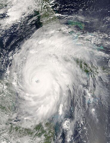
| 解説 | Now a powerful and rare Category 5 storm, Hurricane Ivan is moving between Cuba, right, and the Yucatan Peninsula, left into the Gulf of Mexico. When the Moderate Resolution Imaging Spectroradiometer (MODIS) on NASA’s Terra satellite acquired this image at 15:55 UTC (10:55 a.m. EDT) on September 13, 2004, the storm boasted winds of 260 kilometers per hour (160 mph). The storm was located about 110 kilometers southeast of Cuba, and was moving northwest at 13 kilometers per hour (8 mph). For more information about Ivan, please visit the National Hurricane Center. | |||||
| 日付 | ||||||
| 原典 | http://visibleearth.nasa.gov/view_rec.php?id=6640 | |||||
| 作者 | Jacques Descloitres, MODIS Rapid Response Team, NASA/GSFC | |||||
| 許可 (ファイルの再利用) |
|

ファイルの履歴
過去の版のファイルを表示するには、その版の日時をクリックしてください。
| 日付と時刻 | サムネイル | 寸法 | 利用者 | コメント | |
|---|---|---|---|---|---|
| 現在の版 | 2006年9月23日 (土) 14:55 | | 6,000 × 7,800 (6.43メガバイト) | Good kitty | == Summary == {{Information |Description=Now a powerful and rare Category 5 storm, Hurricane Ivan is moving between Cuba, right, and the Yucatan Peninsula, left into the Gulf of Mexico. When the Moderate Resolution Imaging Spectroradiometer (MODIS) on NAS |
ファイルの使用状況
このファイルを使用しているページはありません。
グローバルなファイル使用状況
以下に挙げる他のウィキがこの画像を使っています:
- de.wikipedia.org での使用状況
- en.wikipedia.org での使用状況
- fr.wikipedia.org での使用状況
- lv.wikipedia.org での使用状況
- pt.wikipedia.org での使用状況