
ファイル:FRONT PORCH - Pioneer Hotel, Front and Hotel Streets, Lahaina, Maui County, HI HABS HI,5-LAHA,7-4.tif

この TIF ファイルのこの JPG プレビューのサイズ: 431 × 600 ピクセル. その他の解像度: 172 × 240 ピクセル | 345 × 480 ピクセル | 552 × 768 ピクセル | 736 × 1,024 ピクセル | 1,472 × 2,048 ピクセル | 3,593 × 5,000 ピクセル。
元のファイル (3,593 × 5,000 ピクセル、ファイルサイズ: 17.14メガバイト、MIME タイプ: image/tiff)
ウィキメディア・コモンズのファイルページにある説明を、以下に表示します。
|
概要
| FRONT PORCH - Pioneer Hotel, Front and Hotel Streets, Lahaina, Maui County, HI | ||||
|---|---|---|---|---|
| 写真家 |
Jack E. Boucher |
|||
| タイトル |
FRONT PORCH - Pioneer Hotel, Front and Hotel Streets, Lahaina, Maui County, HI |
|||
| 描画された場所 | Hawaii; Maui County; Lahaina | |||
| 日付 | 1966年7月 | |||
| 寸法 | 5 x 7 in. | |||
| 所蔵 |
Library of Congress Prints and Photographs Division Washington, D.C. 20540 USA http://hdl.loc.gov/loc.pnp/pp.print |
|||
| 台帳番号 |
HABS HI,5-LAHA,7-4 |
|||
| 受入/取得方法 |
|
|||
| 備考 |
|
|||
| 原典 | https://www.loc.gov/pictures/item/hi0013.photos.058681p | |||
| 許可 (ファイルの再利用) |
|
|||

| 被写体の位置 | | 以下のサービスでこの位置を確認する: オープンストリートマップ |
|---|
ファイルの履歴
過去の版のファイルを表示するには、その版の日時をクリックしてください。
| 日付と時刻 | サムネイル | 寸法 | 利用者 | コメント | |
|---|---|---|---|---|---|
| 現在の版 | 2014年7月15日 (火) 16:19 | 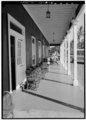 | 3,593 × 5,000 (17.14メガバイト) | Fæ | GWToolset: Creating mediafile for Fæ. HABS 09 July 2014 (801:1000) |
ファイルの使用状況
以下のページがこのファイルを使用しています: