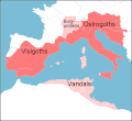
ファイル:Empire of Theodoric the Great 523.gif
Empire_of_Theodoric_the_Great_523.gif (523 × 478 ピクセル、ファイルサイズ: 33キロバイト、MIME タイプ: image/gif)
ファイルの履歴
過去の版のファイルを表示するには、その版の日時をクリックしてください。
| 日付と時刻 | サムネイル | 寸法 | 利用者 | コメント | |
|---|---|---|---|---|---|
| 現在の版 | 2011年12月20日 (火) 13:15 |  | 523 × 478 (33キロバイト) | OgreBot | (BOT): Reverting to most recent version before archival |
| 2011年12月20日 (火) 13:15 |  | 523 × 478 (33キロバイト) | OgreBot | (BOT): Uploading old version of file from en.wikipedia; originally uploaded on 2007-12-27 12:01:51 by Vortimer | |
| 2011年12月20日 (火) 13:15 |  | 523 × 478 (32キロバイト) | OgreBot | (BOT): Uploading old version of file from en.wikipedia; originally uploaded on 2007-12-27 11:57:01 by Vortimer | |
| 2011年9月12日 (月) 01:55 |  | 523 × 478 (33キロバイト) | File Upload Bot (Magnus Manske) | {{BotMoveToCommons|en.wikipedia|year={{subst:CURRENTYEAR}}|month={{subst:CURRENTMONTHNAME}}|day={{subst:CURRENTDAY}}}} {{Information |Description={{en|Map of the territories (pink) ruled by Theodoric the Great at their height in 523, when he annexed the |
ファイルの使用状況
以下の 2 ページがこのファイルを使用しています:
グローバルなファイル使用状況
以下に挙げる他のウィキがこの画像を使っています:
- af.wikipedia.org での使用状況
- ast.wikipedia.org での使用状況
- ba.wikipedia.org での使用状況
- bg.wikipedia.org での使用状況
- br.wikipedia.org での使用状況
- cs.wikipedia.org での使用状況
- el.wikipedia.org での使用状況
- en.wikipedia.org での使用状況
- en.wiktionary.org での使用状況
- fa.wikipedia.org での使用状況
- fr.wikipedia.org での使用状況
- he.wikipedia.org での使用状況
- ko.wikipedia.org での使用状況
- lv.wikipedia.org での使用状況
- no.wikipedia.org での使用状況
- pt.wikipedia.org での使用状況
- ro.wikipedia.org での使用状況
- ru.wikipedia.org での使用状況
- sl.wikipedia.org での使用状況
- uk.wikipedia.org での使用状況
- zh.wikipedia.org での使用状況


