
ファイル:Dao Niger and Harmakhis Vallis PIA02810.jpg

このプレビューのサイズ: 800 × 519 ピクセル。 その他の解像度: 320 × 208 ピクセル | 640 × 415 ピクセル | 1,024 × 664 ピクセル | 1,280 × 830 ピクセル | 1,637 × 1,062 ピクセル。
元のファイル (1,637 × 1,062 ピクセル、ファイルサイズ: 168キロバイト、MIME タイプ: image/jpeg)
ウィキメディア・コモンズのファイルページにある説明を、以下に表示します。
|
概要
| 解説 |
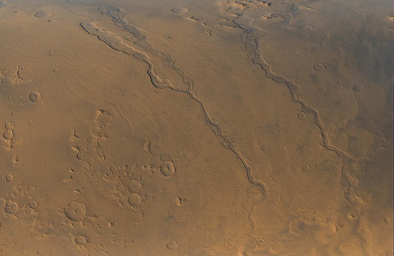
English: The Mars Global Surveyor (MGS) Mars Orbiter Camera (MOC) opened its fourth year orbiting the red planet with this mid-autumn view of three major valley systems east of the Hellas plains. From left to right, the first major valley, Dao Vallis, runs diagonally from the upper left to just past the lower center of the image. Niger Vallis joins Dao Vallis just above the center of the frame. Harmakhis Vallis extends diagonally across the right half of the picture, toward the lower right. These valleys are believed by some to have been formed--at least in part--by large outbursts of liquid water some time far back in the martian past, though there is no way to know exactly how many hundreds of millions or billions of years ago this might have occurred. In each valley, water would have flowed toward the bottom of the image. Although their dimensions vary along their courses, the valleys are all roughly 1 km (0.6 miles) deep and range in width from about 40 km (25 miles) down to about 8 km (5 mi). Located around 40°S, 270°W, the picture covers an area approximately 800 km across and is illuminated by sunlight from the lower left. North is toward the left; the picture is a composite of red and blue wide angle images obtained by MOC on September 13, 2000, |
| 原典 | http://photojournal.jpl.nasa.gov/catalog/PIA02810 |
| 作者 | NASA/JPL/MSSS |
ライセンス
| このファイルはアメリカ航空宇宙局(NASA)によって作成されたものです。NASAの著作権の方針では、特記事項が無い場合、NASAの資料はパブリックドメインとなります。 (詳しくはTemplate:PD-USGov、NASAの著作権の方針について(英語)又はジェット推進研究所(JPL)の画像使用に関するガイドライン(英語)をご覧ください。) |
||
 |
注意事項:
|
ファイルの履歴
過去の版のファイルを表示するには、その版の日時をクリックしてください。
| 日付と時刻 | サムネイル | 寸法 | 利用者 | コメント | |
|---|---|---|---|---|---|
| 現在の版 | 2008年4月12日 (土) 06:55 | | 1,637 × 1,062 (168キロバイト) | Bryan Derksen | {{Information |Description={{en| The Mars Global Surveyor (MGS) Mars Orbiter Camera (MOC) opened its fourth year orbiting the red planet with this mid-autumn view of three major valley systems east of the Hellas plains. From left to right, the first ma |
ファイルの使用状況
以下のページがこのファイルを使用しています:
グローバルなファイル使用状況
以下に挙げる他のウィキがこの画像を使っています:
- ca.wikipedia.org での使用状況
- cs.wikipedia.org での使用状況
- en.wikipedia.org での使用状況
- es.wikipedia.org での使用状況
- fr.wikipedia.org での使用状況
- it.wikipedia.org での使用状況
- pl.wikipedia.org での使用状況
- pt.wikipedia.org での使用状況
- uk.wikipedia.org での使用状況
- www.wikidata.org での使用状況
- zh.wikipedia.org での使用状況