
ファイル:CircumnavigationByCapes.png
CircumnavigationByCapes.png (800 × 500 ピクセル、ファイルサイズ: 286キロバイト、MIME タイプ: image/png)
ウィキメディア・コモンズのファイルページにある説明を、以下に表示します。
|
概要
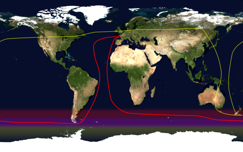
This image shows the route, in red, of a typical round-the-world yacht race via the great capes, by way of the roaring forties. Shown in yellow is the antipodean point of each point on the route; it can be seen that a boat following this route will not pass through any pair of antipodal points. Since doing so in the context of a race — particularly a non-stop race — would be impractical, yacht racing uses a different definition of a circumnavigation.
This image was constructed from a public domain Visible Earth product of the Earth Observatory office of the United States government space agency NASA. It is based on a cylindrical equi-distant projection.
ライセンス
| このファイルはアメリカ航空宇宙局(NASA)によって作成されたものです。NASAの著作権の方針では、特記事項が無い場合、NASAの資料はパブリックドメインとなります。 (詳しくはTemplate:PD-USGov、NASAの著作権の方針について(英語)又はジェット推進研究所(JPL)の画像使用に関するガイドライン(英語)をご覧ください。) |
||
 |
注意事項:
|
ファイルの履歴
過去の版のファイルを表示するには、その版の日時をクリックしてください。
| 日付と時刻 | サムネイル | 寸法 | 利用者 | コメント | |
|---|---|---|---|---|---|
| 現在の版 | 2006年1月23日 (月) 16:09 | | 800 × 500 (286キロバイト) | Johantheghost | This image shows the route, in red, of a typical round-the-world yacht race via the great capes, by way of the roaring forties. Shown in yellow is the [[Wikipedia:antipodes |
ファイルの使用状況
以下のページがこのファイルを使用しています:
グローバルなファイル使用状況
以下に挙げる他のウィキがこの画像を使っています:
- ast.wikipedia.org での使用状況
- en.wikipedia.org での使用状況
- es.wikipedia.org での使用状況
- fr.wikipedia.org での使用状況
- he.wikipedia.org での使用状況
- ko.wikipedia.org での使用状況
- la.wikipedia.org での使用状況
- nl.wikipedia.org での使用状況
- pl.wikipedia.org での使用状況
- pt.wikipedia.org での使用状況
- uk.wikipedia.org での使用状況