
ファイル:CanalZone.png

このプレビューのサイズ: 440 × 599 ピクセル。 その他の解像度: 176 × 240 ピクセル | 520 × 708 ピクセル。
元のファイル (520 × 708 ピクセル、ファイルサイズ: 265キロバイト、MIME タイプ: image/png)
ウィキメディア・コモンズのファイルページにある説明を、以下に表示します。
|
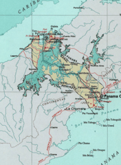
Map of the Panama Canal Zone. from the National Atlas アーカイブされたコピー at the Wayback Machine via American Memory.
This map was obtained from an edition of the National Atlas of the United States. Like almost all works of the U.S. federal government, works from the National Atlas are in the public domain in the United States.
Online access: NationalAtlas.gov | 1970 print edition: Library of Congress, Perry-Castañeda Library
|
元のアップロードログ
| 日付と時刻 | 寸法 | 利用者 | コメント |
|---|---|---|---|
| 2005年4月29日, 04:29:04 | 520 × 708 (314279 bytes) | Hoshie (トーク · 投稿記録) | Map of the Panama Canal Zone. from the [http://www.nationalatlas.gov/ National Atlas] via [http://memory.loc.gov/ammem/gmdhtml/census3.html American Memory]. {{PD-USGov-Atlas}} |
ファイルの履歴
過去の版のファイルを表示するには、その版の日時をクリックしてください。
| 日付と時刻 | サムネイル | 寸法 | 利用者 | コメント | |
|---|---|---|---|---|---|
| 現在の版 | 2014年10月1日 (水) 09:24 | | 520 × 708 (265キロバイト) | RokerHRO | optipng -o7 → 23.74% decrease |
| 2014年8月29日 (金) 10:52 |  | 520 × 708 (348キロバイト) | GifTagger | Bot: Converting file to superior PNG file. (Source: CanalZone.gif). This GIF was problematic due to non-greyscale color table. |
ファイルの使用状況
以下の 3 ページがこのファイルを使用しています:
グローバルなファイル使用状況
以下に挙げる他のウィキがこの画像を使っています:
- ang.wikipedia.org での使用状況
- ar.wikipedia.org での使用状況
- be.wikipedia.org での使用状況
- bg.wikipedia.org での使用状況
- bn.wikipedia.org での使用状況
- ca.wikipedia.org での使用状況
- cs.wikipedia.org での使用状況
- da.wikipedia.org での使用状況
- de.wikipedia.org での使用状況
- en.wikipedia.org での使用状況
- eo.wikipedia.org での使用状況
- es.wikipedia.org での使用状況
- fa.wikipedia.org での使用状況
- fr.wikipedia.org での使用状況
- he.wikipedia.org での使用状況
- hu.wikipedia.org での使用状況
- id.wikipedia.org での使用状況
- it.wikipedia.org での使用状況
- ka.wikipedia.org での使用状況
- ko.wikipedia.org での使用状況
- lt.wikipedia.org での使用状況
- lv.wikipedia.org での使用状況
- ms.wikipedia.org での使用状況
このファイルのグローバル使用状況を表示する。