
ファイル:Arabian Desert.jpg
Arabian_Desert.jpg (500 × 428 ピクセル、ファイルサイズ: 116キロバイト、MIME タイプ: image/jpeg)
ウィキメディア・コモンズのファイルページにある説明を、以下に表示します。
|
概要
| 解説 |
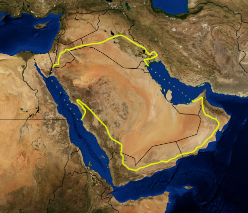
This is a map showing the location of the Arabian Desert. The yellow line encloses ecoregions as delineated by the World Wide Fund for Nature: the "Arabian Desert and East Sahero-Arabian xeric shrublands", and the "Arabian Gulf desert and semi-desert" (a narrow strip along the Persian Gulf coast), and the "Red Sea Nubo-Sindian tropical desert and semi-desert" (along the Red Sea and in patches throughout the Arabian peninsula). National boundaries are shown in black. I, Pfly, made it using NASA Blue Marble imagery and ecoregion GIS data which I simplified and digitized in Photoshop. WWF code PA1303 |
| 日付 | |
| 原典 | NASA, plus my additions by myself. |
| 作者 | Pfly |
ライセンス
| このファイルはアメリカ航空宇宙局(NASA)によって作成されたものです。NASAの著作権の方針では、特記事項が無い場合、NASAの資料はパブリックドメインとなります。 (詳しくはTemplate:PD-USGov、NASAの著作権の方針について(英語)又はジェット推進研究所(JPL)の画像使用に関するガイドライン(英語)をご覧ください。) |
||
 |
注意事項:
|
ファイルの履歴
過去の版のファイルを表示するには、その版の日時をクリックしてください。
| 日付と時刻 | サムネイル | 寸法 | 利用者 | コメント | |
|---|---|---|---|---|---|
| 現在の版 | 2007年1月22日 (月) 21:39 | | 500 × 428 (116キロバイト) | Pfly | {{Information |Description=This is a map showing the location of the Desert. The yellow line encloses ecoregions as delineated by the World Wide Fund for Nature: the "Arabian Desert and East Sahero |
ファイルの使用状況
以下のページがこのファイルを使用しています:
グローバルなファイル使用状況
以下に挙げる他のウィキがこの画像を使っています:
- an.wikipedia.org での使用状況
- ar.wikipedia.org での使用状況
- arz.wikipedia.org での使用状況
- ast.wikipedia.org での使用状況
- azb.wikipedia.org での使用状況
- az.wikipedia.org での使用状況
- ba.wikipedia.org での使用状況
- bg.wikipedia.org での使用状況
- bn.wikipedia.org での使用状況
- bs.wikipedia.org での使用状況
- ca.wikipedia.org での使用状況
- ckb.wikipedia.org での使用状況
- cs.wikipedia.org での使用状況
- da.wikipedia.org での使用状況
- el.wikipedia.org での使用状況
- eo.wikipedia.org での使用状況
- es.wikipedia.org での使用状況
- eu.wikipedia.org での使用状況
- fa.wikipedia.org での使用状況
- fi.wikipedia.org での使用状況
- fr.wikipedia.org での使用状況
- gd.wikipedia.org での使用状況
- gl.wikipedia.org での使用状況
- he.wikipedia.org での使用状況
- hy.wikipedia.org での使用状況
- it.wikipedia.org での使用状況
- ka.wikipedia.org での使用状況
- kn.wikipedia.org での使用状況
- ko.wikipedia.org での使用状況
- ky.wikipedia.org での使用状況
- lt.wikipedia.org での使用状況
- mai.wikipedia.org での使用状況
- ml.wikipedia.org での使用状況
- ne.wikipedia.org での使用状況
- nl.wikipedia.org での使用状況
- nn.wikipedia.org での使用状況
- no.wikipedia.org での使用状況
- oc.wikipedia.org での使用状況
- pa.wikipedia.org での使用状況
- pnb.wikipedia.org での使用状況
- pt.wikipedia.org での使用状況
このファイルのグローバル使用状況を表示する。