
ファイル:Ankara districts.png
高解像度版はありません。
Ankara_districts.png (733 × 600 ピクセル、ファイルサイズ: 166キロバイト、MIME タイプ: image/png)
ウィキメディア・コモンズのファイルページにある説明を、以下に表示します。
|
概要
| 解説 |
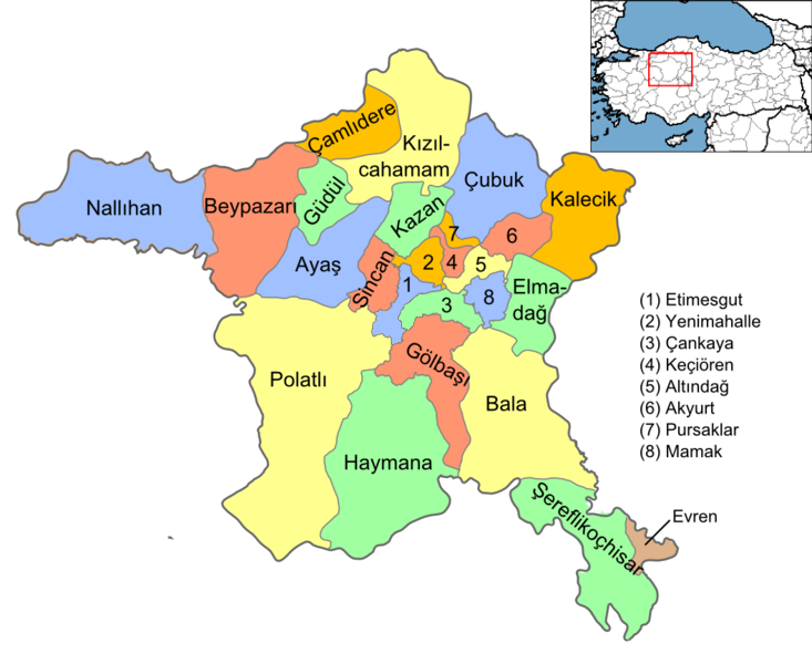
English: Map of the districts of Ankara province of Turkey. Created by Rarelibra 16:37, 1 December 2006 (UTC) for public domain use, using MapInfo Professional v8.5 and various mapping resources. Edited by One Homo Sapiens Corrected text where İ,Ş,ı,ğ,or ş occurs in name. Source: [statoids-com]. Increased font size and enhanced color differences among adjacent districts. |
| 日付 | 2006年12月1日 (当初のアップロード日) |
| 原典 | コンピュータが読み取れる情報は提供されていませんが、投稿者自身による著作物だと推定されます(著作権の主張に基づく) |
| 作者 | コンピュータが読み取れる情報は提供されていませんが、Rarelibraだと推定されます(著作権の主張に基づく) |
ライセンス
| この著作物の著作権者である私は、この著作物における権利を放棄しパブリックドメインとします。これは全世界で適用されます。 一部の国では、これが法的に可能ではない場合があります。その場合は、次のように宣言します。 私は、あらゆる人に対して、法により必要とされている条件を除き、如何なる条件も課すことなく、あらゆる目的のためにこの著作物を使用する権利を与えます。 |
ファイルの履歴
過去の版のファイルを表示するには、その版の日時をクリックしてください。
| 日付と時刻 | サムネイル | 寸法 | 利用者 | コメント | |
|---|---|---|---|---|---|
| 現在の版 | 2015年9月15日 (火) 15:08 | | 733 × 600 (166キロバイト) | AylakBiri | Yeni sınırlar. |
| 2014年6月1日 (日) 18:59 |  | 1,056 × 864 (198キロバイト) | Joseph48 | - "Pursaklar" added. - Borders changed using File:Ankara location Pursaklar.svg | |
| 2011年10月22日 (土) 18:00 |  | 1,056 × 816 (48キロバイト) | Karedefter | small things | |
| 2010年11月21日 (日) 19:40 |  | 1,056 × 816 (48キロバイト) | Joseph48 | Şultan Koçhisar > Şerefli Koçhisar | |
| 2008年12月28日 (日) 20:37 |  | 1,056 × 816 (41キロバイト) | One Homo Sapiens | Corrected text where İ,Ş,ı,ğ,or ş occurs in name. Source: [statoids-com]. Increased font size and enhanced color differences among adjacent districts. | |
| 2006年12月1日 (金) 16:37 |  | 1,056 × 816 (40キロバイト) | Rarelibra | Map of the districts of Ankara province of Turkey. Created by ~~~~ for public domain use, using MapInfo Professional v8.5 and various mapping resources. |
ファイルの使用状況
グローバルなファイル使用状況
以下に挙げる他のウィキがこの画像を使っています:
- ar.wikipedia.org での使用状況
- azb.wikipedia.org での使用状況
- az.wikipedia.org での使用状況
- ba.wikipedia.org での使用状況
- br.wikipedia.org での使用状況
- ca.wikipedia.org での使用状況
- ceb.wikipedia.org での使用状況
- ckb.wikipedia.org での使用状況
- crh.wikipedia.org での使用状況
- cs.wikipedia.org での使用状況
- cy.wikipedia.org での使用状況
- de.wikipedia.org での使用状況
- Şereflikoçhisar
- Ankara (Provinz)
- Kızılcahamam
- Etimesgut
- Gölbaşı (Ankara)
- Haymana
- Evren (Ankara)
- Polatlı
- Sincan (Ankara)
- Vorlage:Navigationsleiste Landkreise der Provinz Ankara
- Çankaya
- Keçiören
- Mamak
- Kalecik
- Beypazarı
- Ayaş (Ankara)
- Yenimahalle
- Altındağ
- Balâ
- Elmadağ (Ankara)
- Nallıhan
- Pursaklar
- Çamlıdere (Ankara)
このファイルのグローバル使用状況を表示する。