
ファイル:1686 Mallet Map of Ceylon or Sri Lanka (Taprobane) - Geographicus - Taprobane-mallet-1686.jpg

このプレビューのサイズ: 472 × 599 ピクセル。 その他の解像度: 189 × 240 ピクセル | 378 × 480 ピクセル | 605 × 768 ピクセル | 807 × 1,024 ピクセル | 1,602 × 2,033 ピクセル。
元のファイル (1,602 × 2,033 ピクセル、ファイルサイズ: 1メガバイト、MIME タイプ: image/jpeg)
ウィキメディア・コモンズのファイルページにある説明を、以下に表示します。
|
_-_Geographicus_-_Taprobane-mallet-1686.jpg?uselang=ja)
_-_Geographicus_-_Taprobane-mallet-1686.jpg?uselang=ja)
_-_Geographicus_-_Taprobane-mallet-1686.jpg?uselang=ja&action=history)
_-_Geographicus_-_Taprobane-mallet-1686.jpg)
| Ancienne Isle Taprobane. Die alte Insel Tabrobane. | ||||||
|---|---|---|---|---|---|---|
| 作者 | ||||||
| タイトル |
Ancienne Isle Taprobane. Die alte Insel Tabrobane. |
|||||
| 解説 |
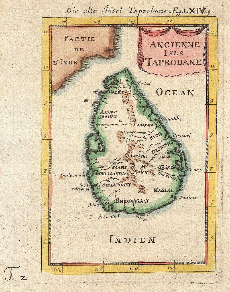
English: A beautiful miniature 1683 map of Ceylon, Sri Lanka, or Taprobane by Alain Mallet. This stunning little map covers the island of Ceylon as well as parts of adjacent India. Mallet first introduced this map in the 1683 though it was republished several time in the subsequent 20 years. Taprobane is an ancient name for a spice rich trading center that was well known in ancient Roman times. By the 17th century Portuguese explorers had reopened the route to the Indies but were uncertain exactly which island the Romans were referring to. Some map Taprobrane as Sumatra, other as Ceylon. The common consensus now, as in Mallet’s time, is that the Roman Taprobane is Ceylon. Published by copper plate in the 1686 Frankfurt edition of Mallet’s Description de l'Univers. |
|||||
| 日付 | 1686年 (undated) | |||||
| 寸法 | 高さ: 7 in (17.7 cm);幅: 5 in (12.7 cm) | |||||
| 台帳番号 |
Geographicus link: Taprobane-mallet-1686 |
|||||
| 情報源/撮影者 |
Mallet, A., Description de l'Univers, (Frankfurt), 1686.
|
|||||
| 許可 (ファイルの再利用) |
|
|||||
ファイルの履歴
過去の版のファイルを表示するには、その版の日時をクリックしてください。
| 日付と時刻 | サムネイル | 寸法 | 利用者 | コメント | |
|---|---|---|---|---|---|
| 現在の版 | 2011年3月24日 (木) 22:17 | | 1,602 × 2,033 (1メガバイト) | BotMultichillT | {{subst:User:Multichill/Geographicus |link=http://www.geographicus.com/P/AntiqueMap/Taprobane-mallet-1686 |product_name=1686 Mallet Map of Ceylon or Sri Lanka (Taprobane) |map_title=Ancienne Isle Taprobane. Die alte Insel Tabrobane. |description=A beautif |
ファイルの使用状況
以下のページがこのファイルを使用しています:
グローバルなファイル使用状況
以下に挙げる他のウィキがこの画像を使っています:
- ar.wikipedia.org での使用状況
- ckb.wikipedia.org での使用状況
- en.wikipedia.org での使用状況
- History of Sri Lanka
- Mahāvaṃsa
- Beminitiya Seya
- Cūḷavaṃsa
- Sri Lankan independence movement
- Dīpavaṃsa
- Template:History of Sri Lanka
- Capital of Sri Lanka
- Prehistory of Sri Lanka
- User:Blackknight12/List of historical Sri Lankan overseas military operations
- British Ceylon period
- History of Sri Lanka (1948–present)
- Anuradhapura period
- Chola conquest of Anuradhapura
- User:༆/History of Asia templates
- User:Blackknight12/sandbox
- List of wars involving Sri Lanka
- Pre-Anuradhapura period
- Polonnaruwa period
- Transitional period of Sri Lanka
- Rajavaliya
- Kandyan period
- Crisis of the Sixteenth Century
- Template:History of Sri Lanka/doc
- Malay invasions of Sri Lanka
- Cartography of Sri Lanka
- User:Lesa2006/sandbox
- fa.wikipedia.org での使用状況
- fi.wikipedia.org での使用状況
- fr.wikipedia.org での使用状況
- km.wikipedia.org での使用状況
- ko.wikipedia.org での使用状況
このファイルのグローバル使用状況を表示する。
_-_Geographicus_-_Taprobane-mallet-1686.jpg)
_-_Geographicus_-_Taprobane-mallet-1686.jpg)