
ファイル:Thames river 1882.jpg
このプレビューのサイズ: 799 × 216 ピクセル。 その他の解像度: 320 × 87 ピクセル | 640 × 173 ピクセル | 1,024 × 277 ピクセル | 1,280 × 346 ピクセル | 4,499 × 1,217 ピクセル。
元のファイル (4,499 × 1,217 ピクセル、ファイルサイズ: 982キロバイト、MIME タイプ: image/jpeg)
ウィキメディア・コモンズのファイルページにある説明を、以下に表示します。
|
概要
| 解説 |
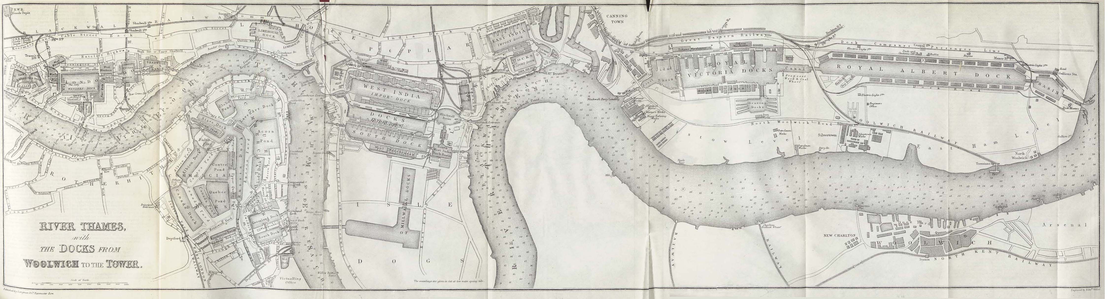
English: "River Thames with the Docks from Woolwich to the Tower" from This map shows all of the main upstream London docks except the King George V Dock, which had not been built. It was to be located to the south of the Royal Albert Dock, which is the large dock at the far right. |
| 日付 | |
| 原典 | A Dictionary Practical, Theoretical, and Historical of Commerce and Commercial Navigation by J.R. M'Culloch - Longmans, Green and Co. London, 1882 |
| 作者 | Edward Weller (d. 1884) [1] |
ライセンス
|
このファイルは、パブリックドメインの状態にある平面的な美術の著作物を写真術によって忠実に複製したものです。このような複製はアメリカ合衆国においてパブリックドメインの状態にあります。その他の地域では再利用に制限がかかる場合があります。詳しくはReuse of PD-Art photographsをご覧ください。美術の著作物としての原図は、次の理由によりパブリックドメインの状態にあります。
| ||||
References
ファイルの履歴
過去の版のファイルを表示するには、その版の日時をクリックしてください。
| 日付と時刻 | サムネイル | 寸法 | 利用者 | コメント | |
|---|---|---|---|---|---|
| 現在の版 | 2006年4月9日 (日) 09:36 | 4,499 × 1,217 (982キロバイト) | White-Silent-Night | "River Thames with the Docks from Woolwich to the Tower" from ''A Dictionary Practical, Theoretical, and Historical of Commerce and Commercial Navigation'' by J.R. M'Culloch. Longmans, Green and Co. London, 1882. This map shows all of the main upstream Lo |
ファイルの使用状況
以下のページがこのファイルを使用しています:
グローバルなファイル使用状況
以下に挙げる他のウィキがこの画像を使っています:
- ar.wikipedia.org での使用状況
- de.wikipedia.org での使用状況
- en.wikipedia.org での使用状況
- eo.wikipedia.org での使用状況
- es.wikipedia.org での使用状況
- fr.wikipedia.org での使用状況
- he.wikipedia.org での使用状況
- it.wikipedia.org での使用状況
- nl.wikipedia.org での使用状況
- pl.wikipedia.org での使用状況
- ru.wikipedia.org での使用状況
- sl.wikipedia.org での使用状況
- zh.wikipedia.org での使用状況