
ファイル:SatavahanaMap.jpg

このプレビューのサイズ: 467 × 599 ピクセル。 その他の解像度: 187 × 240 ピクセル | 374 × 480 ピクセル | 599 × 768 ピクセル | 1,123 × 1,440 ピクセル。
元のファイル (1,123 × 1,440 ピクセル、ファイルサイズ: 327キロバイト、MIME タイプ: image/jpeg)
ウィキメディア・コモンズのファイルページにある説明を、以下に表示します。
|

|
This map has been uploaded by Electionworld from en.wikipedia.org to enable the |

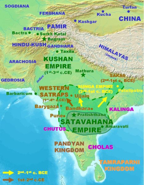
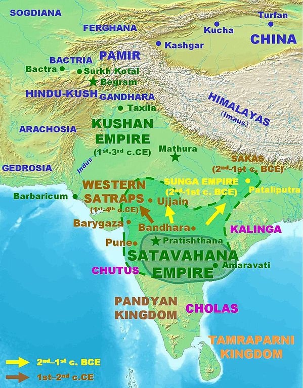
Approximate extent of the Satavahana Empire.
Personal map, 2005. Released in the Public Domain.
| この著作物は、著作者であるPHGによって権利が放棄され、パブリックドメインとされました。これは全世界で適用されます。 一部の国では、これが法的に可能ではない場合があります。その場合は、次のように宣言します。 |
ファイルの履歴
過去の版のファイルを表示するには、その版の日時をクリックしてください。
| 日付と時刻 | サムネイル | 寸法 | 利用者 | コメント | |
|---|---|---|---|---|---|
| 現在の版 | 2007年3月18日 (日) 14:09 | | 1,123 × 1,440 (327キロバイト) | World Imaging | Better map, personal creation. |
| 2006年12月13日 (水) 23:21 |  | 395 × 432 (29キロバイト) | Electionworld | {{ew|en|PHG}} {{POV-map}} Approximate extent of the Satavahana Empire. Personal map, 2005. Released in the Public Domain. {{pd}} |
ファイルの使用状況
このファイルを使用しているページはありません。
グローバルなファイル使用状況
以下に挙げる他のウィキがこの画像を使っています:
- ba.wikipedia.org での使用状況
- bn.wikipedia.org での使用状況
- ca.wikipedia.org での使用状況
- cs.wikipedia.org での使用状況
- cv.wikipedia.org での使用状況
- de.wikipedia.org での使用状況
- en.wikipedia.org での使用状況
- es.wikipedia.org での使用状況
- eu.wikipedia.org での使用状況
- fa.wikipedia.org での使用状況
- fi.wikipedia.org での使用状況
- fr.wikipedia.org での使用状況
- hi.wikipedia.org での使用状況
- hy.wikipedia.org での使用状況
- id.wikipedia.org での使用状況
- id.wikibooks.org での使用状況
- it.wikipedia.org での使用状況
- kn.wikipedia.org での使用状況
- ko.wikipedia.org での使用状況
- lt.wikipedia.org での使用状況
- mr.wikipedia.org での使用状況
- nl.wikipedia.org での使用状況
- pnb.wikipedia.org での使用状況
- ru.wikipedia.org での使用状況
- sa.wikipedia.org での使用状況
- sh.wikipedia.org での使用状況
- si.wikipedia.org での使用状況
- sq.wikipedia.org での使用状況
- sr.wikipedia.org での使用状況
- te.wikipedia.org での使用状況
- th.wikipedia.org での使用状況
- tl.wikipedia.org での使用状況
- tt.wikipedia.org での使用状況
- uk.wikipedia.org での使用状況
- ur.wikipedia.org での使用状況
このファイルのグローバル使用状況を表示する。