
ファイル:Map of the Grand Duchy of Lithuania (pink) and the Crown of the Kingdom of Poland (red) and its neighborhood in 1386 – 1434 (English version).png

このプレビューのサイズ: 609 × 599 ピクセル。 その他の解像度: 244 × 240 ピクセル | 488 × 480 ピクセル | 781 × 768 ピクセル | 1,041 × 1,024 ピクセル | 2,082 × 2,048 ピクセル | 2,977 × 2,929 ピクセル。
元のファイル (2,977 × 2,929 ピクセル、ファイルサイズ: 2.13メガバイト、MIME タイプ: image/png)
ウィキメディア・コモンズのファイルページにある説明を、以下に表示します。
|
_and_the_Crown_of_the_Kingdom_of_Poland_(red)_and_its_neighborhood_in_1386_%E2%80%93_1434_(English_version).png?uselang=ja)
_and_the_Crown_of_the_Kingdom_of_Poland_(red)_and_its_neighborhood_in_1386_%E2%80%93_1434_(English_version).png?uselang=ja)
_and_the_Crown_of_the_Kingdom_of_Poland_(red)_and_its_neighborhood_in_1386_%E2%80%93_1434_(English_version).png?uselang=ja&action=history)
_and_the_Crown_of_the_Kingdom_of_Poland_(red)_and_its_neighborhood_in_1386_%E2%80%93_1434_(English_version).png)
概要
| 解説 |
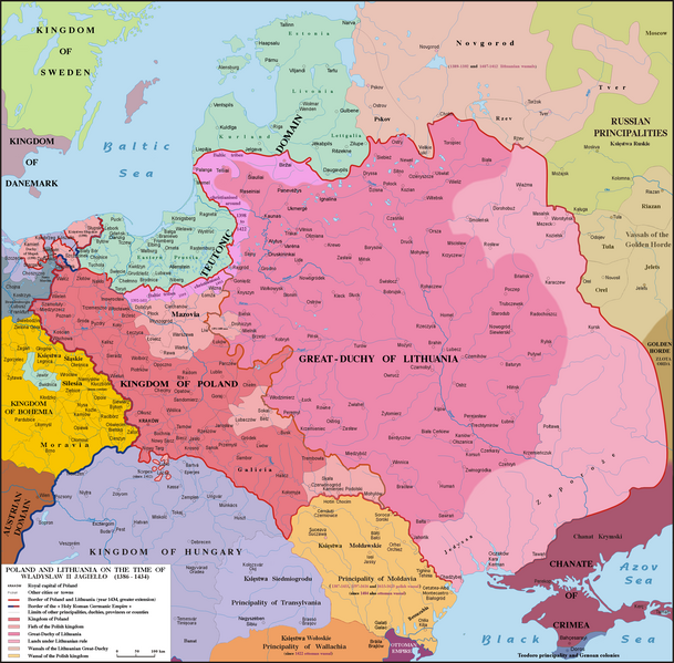
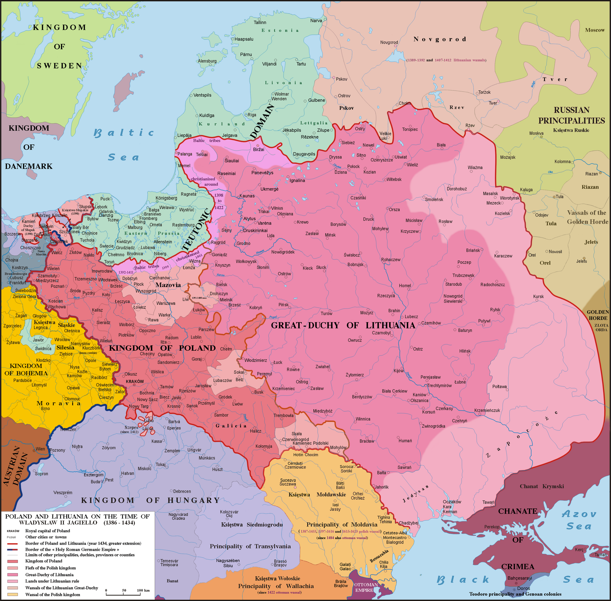
English: Map of Poland, Lithuania & neighbourough 1386-1434. Graphic derivative map since https://fr.wikipedia.org/wiki/Yedisan#/media/File:Polska_1386_-_1434.png but English version and without the 5 mistakes of the original map (impossible to be corrected because the first uploader reverts the new versions) : 1)- Moldavia wasn't a province or a fief (lenno in polish) of the Polish kingdom, but a principality, vassal of Poland from 1387 to 1455, from 1597 to 1616 & from 1615 to 1623 : the Moldavian prince were not a Polish sir appointed by the polish King but a Moldavian boyard elected by the Moldavian Sfat ; 2)- The name Hospodar for the Moldavian princes aren’t in use before the XVIth century ; 3)- In this time Kilja was on the south side of Chilia arm (today Chilia Veche in Romania, not the new Kilija in Ukraine) ; 4)- Danube delta was moldavian till 1484 and the shoreline was different in 1400 ; 5)- Akkerman is not another town but the turkish name (given since 1484) of Bialgorod also named in this time Cetatea-Alba & Montecastro. Sources: Hans-Erich Stier (dir.) "Grosser Atlas zur Weltgeschichte", Ed. Westermann 1985, ISBN 3-14-100919-8, "Történelmi atlasz", Magyar Academy 1991, ISBN 963-351422-3 CM, "Atlas istorico-geografic", Ed. Academica 1994, ISBN 973-27-0500-0, Constantin C. Giurescu & Dinu C. Giurescu :" History of the Romanian lands", Ed. Academica 1985, p.209-210, N. P. Comneanu: "Les principautés roumaines à travers les âges", Ed. Payot, Paris 1919 and Lucian Predescu: "Enciclopedia Cugetarea", p.562-563.
Lietuvių: Lietuvos Didžiosios Kunigaikštystės (rožinė) ir Lenkijos Karalystės Karūnos (raudona) žemėlapis valdant Jogailai 1386 - 1434 m.
Polski: Mapa Polski i Litwy za panowania Władysława II Jagiełły (1386 - 1434). |
| 日付 | |
| 原典 | File:Polska 1386 - 1434.png |
| 作者 |
Poznaniak (original image) Spiridon Ion Cepleanu (derivative work) |
ライセンス
この作品の著作権者である私は、この作品を以下のライセンスで提供します。
このファイルはクリエイティブ・コモンズ 表示-継承 4.0 国際ライセンスのもとに利用を許諾されています。
- あなたは以下の条件に従う場合に限り、自由に
- 共有 – 本作品を複製、頒布、展示、実演できます。
- 再構成 – 二次的著作物を作成できます。
- あなたの従うべき条件は以下の通りです。
- 表示 – あなたは適切なクレジットを表示し、ライセンスへのリンクを提供し、変更があったらその旨を示さなければなりません。これらは合理的であればどのような方法で行っても構いませんが、許諾者があなたやあなたの利用行為を支持していると示唆するような方法は除きます。
- 継承 – もしあなたがこの作品をリミックスしたり、改変したり、加工した場合には、あなたはあなたの貢献部分を元の作品とこれと同一または互換性があるライセンスの下に頒布しなければなりません。
ファイルの履歴
過去の版のファイルを表示するには、その版の日時をクリックしてください。
| 日付と時刻 | サムネイル | 寸法 | 利用者 | コメント | |
|---|---|---|---|---|---|
| 現在の版 | 2016年5月10日 (火) 17:18 | | 2,977 × 2,929 (2.13メガバイト) | Julieta39 | Teodoro principality in Crimea until 1475 |
| 2015年12月6日 (日) 16:11 |  | 2,977 × 2,929 (2.14メガバイト) | Spiridon Ion Cepleanu | Correct orthograph of Lithuania in english | |
| 2015年12月6日 (日) 13:56 |  | 2,977 × 2,929 (2.14メガバイト) | Spiridon Ion Cepleanu | User created page with UploadWizard |
ファイルの使用状況
以下のページがこのファイルを使用しています:
グローバルなファイル使用状況
以下に挙げる他のウィキがこの画像を使っています:
- af.wikipedia.org での使用状況
- als.wikipedia.org での使用状況
- ar.wikipedia.org での使用状況
- az.wikipedia.org での使用状況
- be.wikipedia.org での使用状況
- bg.wikipedia.org での使用状況
- br.wikipedia.org での使用状況
- ca.wikipedia.org での使用状況
- cs.wikipedia.org での使用状況
- da.wikipedia.org での使用状況
- de.wikipedia.org での使用状況
- de.wikibooks.org での使用状況
- de.wikiversity.org での使用状況
- el.wikipedia.org での使用状況
- en.wikipedia.org での使用状況
- et.wikipedia.org での使用状況
- fa.wikipedia.org での使用状況
- fi.wikipedia.org での使用状況
- fr.wikipedia.org での使用状況
- gd.wikipedia.org での使用状況
- hu.wikipedia.org での使用状況
- it.wikipedia.org での使用状況
- lt.wikipedia.org での使用状況
- lt.wikibooks.org での使用状況
- lv.wikipedia.org での使用状況
- sl.wikipedia.org での使用状況
_and_the_Crown_of_the_Kingdom_of_Poland_(red)_and_its_neighborhood_in_1386_–_1434_(English_version).png)