
ファイル:Greater East Asia Conference Map.PNG
このプレビューのサイズ: 800 × 370 ピクセル。 その他の解像度: 320 × 148 ピクセル | 640 × 296 ピクセル | 1,357 × 628 ピクセル。
元のファイル (1,357 × 628 ピクセル、ファイルサイズ: 40キロバイト、MIME タイプ: image/png)
ウィキメディア・コモンズのファイルページにある説明を、以下に表示します。
|
概要
| 解説 |
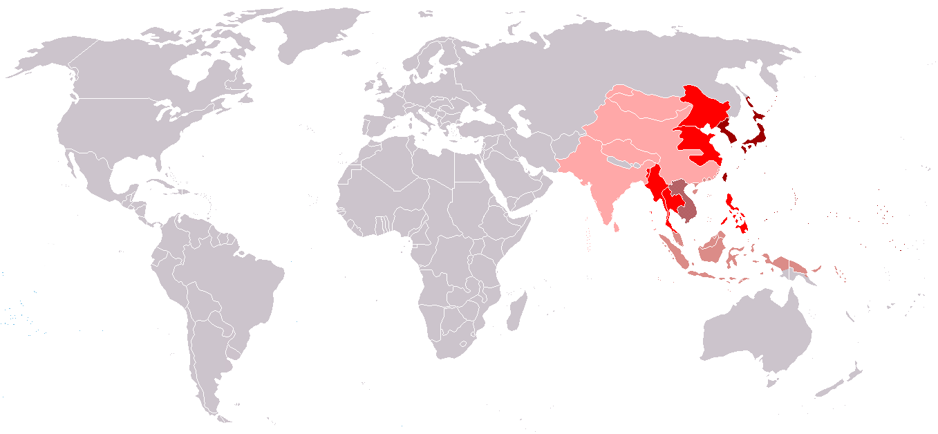
English: Countries - members of the Greater East Asia Conference |
| 日付 | |
| 原典 | 投稿者自身による著作物 |
| 作者 | Makakaaaa |
Japanese empire (host country)
Countries-members of the Greater East Asia Conference
Disputed territories
ライセンス
この作品の著作権者である私は、この作品を以下のライセンスで提供します。
このファイルはクリエイティブ・コモンズ 表示-継承 3.0 非移植ライセンスのもとに利用を許諾されています。
- あなたは以下の条件に従う場合に限り、自由に
- 共有 – 本作品を複製、頒布、展示、実演できます。
- 再構成 – 二次的著作物を作成できます。
- あなたの従うべき条件は以下の通りです。
- 表示 – あなたは適切なクレジットを表示し、ライセンスへのリンクを提供し、変更があったらその旨を示さなければなりません。これらは合理的であればどのような方法で行っても構いませんが、許諾者があなたやあなたの利用行為を支持していると示唆するような方法は除きます。
- 継承 – もしあなたがこの作品をリミックスしたり、改変したり、加工した場合には、あなたはあなたの貢献部分を元の作品とこれと同一または互換性があるライセンスの下に頒布しなければなりません。

|
この文書は、フリーソフトウェア財団発行のGNUフリー文書利用許諾書 (GNU Free Documentation License) 1.2またはそれ以降のバージョンの規約に基づき、複製や再配布、改変が許可されます。不可変更部分、表紙、背表紙はありません。このライセンスの複製は、GNUフリー文書利用許諾書という章に含まれています。 |
あなたは上記のライセンスから、どれか一つ以上を選択できます。
ファイルの履歴
過去の版のファイルを表示するには、その版の日時をクリックしてください。
| 日付と時刻 | サムネイル | 寸法 | 利用者 | コメント | |
|---|---|---|---|---|---|
| 現在の版 | 2020年4月27日 (月) 16:57 | | 1,357 × 628 (40キロバイト) | Paul 012 | Reverting changes - unreferenced; the eastern Pacific areas were never seriously considered |
| 2020年3月2日 (月) 19:14 |  | 1,357 × 628 (54キロバイト) | Satoshi Kondo | 大東亞共榮圈 | |
| 2013年8月28日 (水) 13:43 |  | 1,357 × 628 (40キロバイト) | Elmor | Wang Jingwei regime never made statements recognising independence of Mongolia, Tibet, or Tuva | |
| 2011年4月16日 (土) 12:04 |  | 1,357 × 628 (26キロバイト) | Elmor | proper German borders | |
| 2011年4月12日 (火) 18:29 |  | 1,357 × 628 (47キロバイト) | Lpi4635 | correcting mistake | |
| 2011年4月10日 (日) 20:42 |  | 1,357 × 628 (47キロバイト) | Lpi4635 | corrected mistakes | |
| 2011年4月2日 (土) 11:50 |  | 1,357 × 628 (47キロバイト) | Lpi4635 | Northern Sakhalin was not the part of Japanese Empire | |
| 2011年3月26日 (土) 21:46 |  | 1,357 × 628 (47キロバイト) | Lpi4635 | {{Information |Description ={{en|1=Countries - members of the Greater East Asia Conference}} |Source =own work |Author =Makakaaaa |Date =2011-03-27 |Permission = |other_versions =no }} |
ファイルの使用状況
以下のページがこのファイルを使用しています:
グローバルなファイル使用状況
以下に挙げる他のウィキがこの画像を使っています:
- ar.wikipedia.org での使用状況
- bcl.wikipedia.org での使用状況
- be.wikipedia.org での使用状況
- en.wikipedia.org での使用状況
- fa.wikipedia.org での使用状況
- fr.wikipedia.org での使用状況
- he.wikipedia.org での使用状況
- it.wikipedia.org での使用状況
- pl.wikipedia.org での使用状況
- pt.wikipedia.org での使用状況
- ru.wikipedia.org での使用状況
- tl.wikipedia.org での使用状況
- uk.wikipedia.org での使用状況
- zh.wikipedia.org での使用状況