
ファイル:Great Lakes bathymetry map.png
元のファイル (1,024 × 731 ピクセル、ファイルサイズ: 1.34メガバイト、MIME タイプ: image/png)
ウィキメディア・コモンズのファイルページにある説明を、以下に表示します。
|
概要
| 解説 |
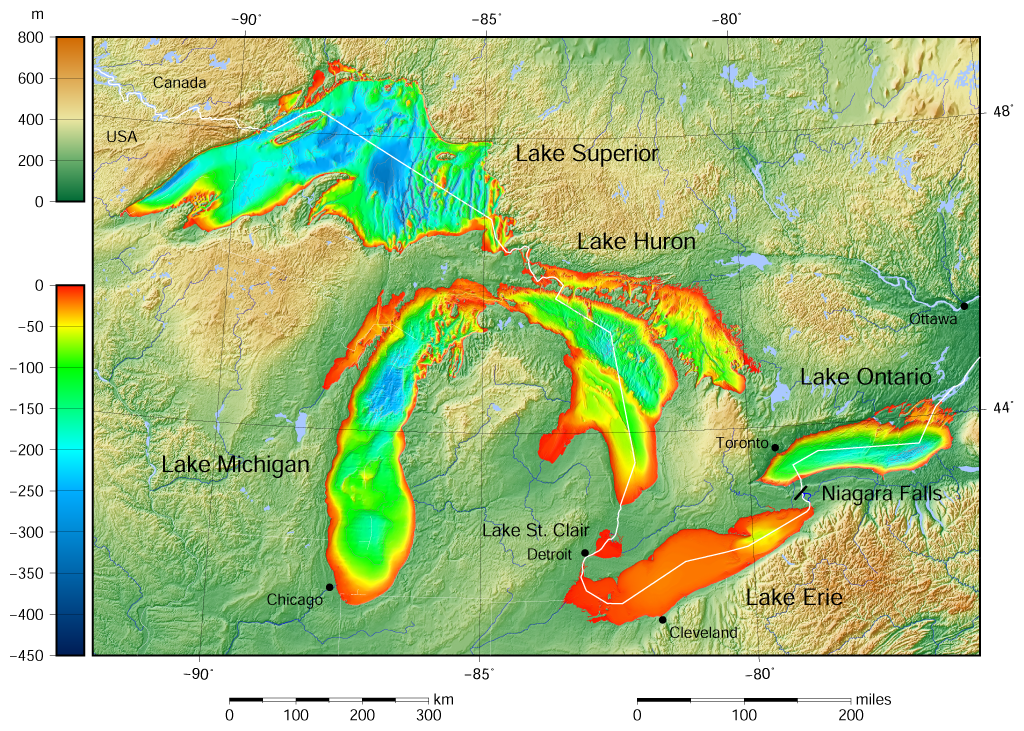
English: Great Lakes bathymetry and surrounding area shaded relief map. Lakes are contoured with interval 100 m. Lake Superior is incomplete. |
| 日付 | |
| 原典 |
次のものを使用した投稿者自身による著作物:: the following Public Domain datasets (grids):
The color palette of the depth scale was made to be more or less similar to the color palettes used on the NGDC Great Lakes maps. |
| 作者 | Darekk2 using the Great Lakes Bathymetry and GLOBE tiles |
| その他のバージョン |
|

ライセンス
Attribution (in addition to the author of this map):
The NGDC in it's copyright notice says:
As required by 17 U.S.C. 403, third parties producing copyrighted works consisting predominantly of the material produced by U.S. government agencies must provide notice with such work(s) identifying the U.S. Government material incorporated and stating that such material is not subject to copyright protection within the United States. (...)
(for credits see the Source section).
and Great Lakes Bathymetry and GLOBE
(see above and the Source section)
- あなたは以下の条件に従う場合に限り、自由に
- 共有 – 本作品を複製、頒布、展示、実演できます。
- 再構成 – 二次的著作物を作成できます。
- あなたの従うべき条件は以下の通りです。
- 表示 – あなたは適切なクレジットを表示し、ライセンスへのリンクを提供し、変更があったらその旨を示さなければなりません。これらは合理的であればどのような方法で行っても構いませんが、許諾者があなたやあなたの利用行為を支持していると示唆するような方法は除きます。
- 継承 – もしあなたがこの作品をリミックスしたり、改変したり、加工した場合には、あなたはあなたの貢献部分を元の作品とこれと同一または互換性があるライセンスの下に頒布しなければなりません。
ファイルの履歴
過去の版のファイルを表示するには、その版の日時をクリックしてください。
| 日付と時刻 | サムネイル | 寸法 | 利用者 | コメント | |
|---|---|---|---|---|---|
| 現在の版 | 2015年5月9日 (土) 15:46 | | 1,024 × 731 (1.34メガバイト) | Darekk2 | more accurate shorelines, the lakes tiles better assembled, added Canada, USA and Lake St. Clair labels, moved Detroit label, Michigan Lake - retouched western part of Green Bay |
| 2015年3月25日 (水) 10:03 |  | 1,024 × 731 (1.34メガバイト) | Darekk2 | changed illumination for shaded relief | |
| 2015年3月25日 (水) 01:29 |  | 1,024 × 731 (1.33メガバイト) | Darekk2 | changed palette a little | |
| 2015年3月24日 (火) 20:21 |  | 1,024 × 731 (1.61メガバイト) | Darekk2 | User created page with UploadWizard |
ファイルの使用状況
以下のページがこのファイルを使用しています:
グローバルなファイル使用状況
以下に挙げる他のウィキがこの画像を使っています:
- ar.wikipedia.org での使用状況
- en.wikipedia.org での使用状況
- fi.wikipedia.org での使用状況
- nl.wikipedia.org での使用状況
- sr.wikipedia.org での使用状況
- tt.wikipedia.org での使用状況
- uk.wikipedia.org での使用状況
- vep.wikipedia.org での使用状況
- www.wikidata.org での使用状況
- zh-yue.wikipedia.org での使用状況