
ファイル:1856 Japanese Edo Period Woodblock Map of Musashi Kuni (Tokyo or Edo Province) - Geographicus - MusashiKuni-japanese-1856.jpg

このプレビューのサイズ: 699 × 599 ピクセル。 その他の解像度: 280 × 240 ピクセル | 560 × 480 ピクセル | 896 × 768 ピクセル | 1,195 × 1,024 ピクセル | 2,389 × 2,048 ピクセル | 6,000 × 5,143 ピクセル。
元のファイル (6,000 × 5,143 ピクセル、ファイルサイズ: 8.51メガバイト、MIME タイプ: image/jpeg)
ウィキメディア・コモンズのファイルページにある説明を、以下に表示します。
|
_-_Geographicus_-_MusashiKuni-japanese-1856.jpg?uselang=ja)
_-_Geographicus_-_MusashiKuni-japanese-1856.jpg?uselang=ja)
_-_Geographicus_-_MusashiKuni-japanese-1856.jpg?uselang=ja&action=history)
_-_Geographicus_-_MusashiKuni-japanese-1856.jpg)
| Musashinokuni.(ja:武蔵国) | ||||||
|---|---|---|---|---|---|---|
| 作者 | ||||||
| タイトル |
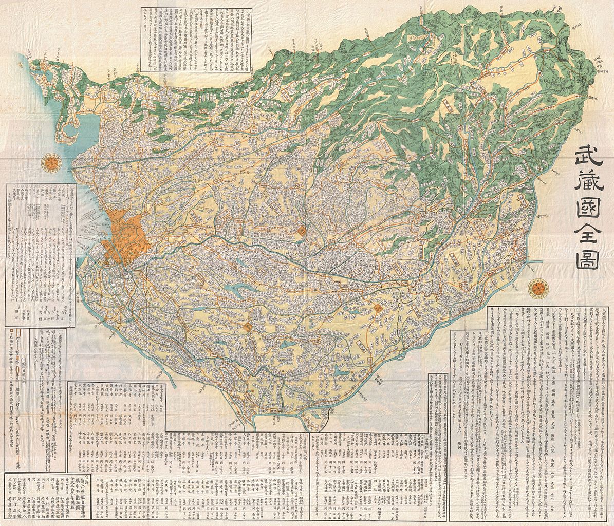
Musashinokuni.(ja:武蔵国) |
|||||
| 解説 |
English: A large-format Edo Period Japanese woodblock map of Musashi Province dating to 1858. Musashi (武蔵国, Musashi no kuni) was a province of Japan, which today comprises Tokyo Prefecture, most of Saitama Prefecture and part of Kanagawa Prefecture, mainly Kawasaki and Yokohama. Musashi bordered on Kai, Kozuke, Sagami, Shimosa, and Shimotsuke Provinces. Musashi was the largest province in the Kanto region. It had its ancient capital in modern Fuchu, Tokyo and its provincial temple in what is now Kokubunji, Tokyo. By the Sengoku period, the main city was Edo, which became the dominant city of eastern Japan. Edo Castle was the headquarters of Tokugawa Ieyasu before the Battle of Sekigahara and became the dominant city of Japan during the Edo period, being renamed Tokyo during the Meiji Restoration. Printed in the traditional Japanese style popular during the Edo Period, with topograpy shown in profile, no firm directional orientation, and map titles in cartouches. |
|||||
| 日付 | 1856年 (dated) | |||||
| 寸法 | 高さ: 44 in (111.7 cm);幅: 51 in (129.5 cm) | |||||
| 台帳番号 |
Geographicus link: MusashiKuni-japanese-1856 |
|||||
| 情報源/撮影者 |
|
|||||
| 許可 (ファイルの再利用) |
|
|||||
ファイルの履歴
過去の版のファイルを表示するには、その版の日時をクリックしてください。
| 日付と時刻 | サムネイル | 寸法 | 利用者 | コメント | |
|---|---|---|---|---|---|
| 現在の版 | 2011年3月24日 (木) 21:29 | | 6,000 × 5,143 (8.51メガバイト) | BotMultichillT | {{subst:User:Multichill/Geographicus |link=http://www.geographicus.com/P/AntiqueMap/MusashiKuni-japanese-1856 |product_name=1856 Japanese Edo Period Woodblock Map of Musashi Kuni (Tokyo or Edo Province) |map_title=Musashi Kuni. |description=A breathtaking |
ファイルの使用状況
以下の 4 ページがこのファイルを使用しています:
グローバルなファイル使用状況
以下に挙げる他のウィキがこの画像を使っています:
- simple.wikipedia.org での使用状況
_-_Geographicus_-_MusashiKuni-japanese-1856.jpg)