
ファイル:British Decolonisation in Africa.png
このプレビューのサイズ: 600 × 600 ピクセル。 その他の解像度: 240 × 240 ピクセル | 480 × 480 ピクセル | 768 × 768 ピクセル | 1,024 × 1,024 ピクセル | 2,000 × 2,000 ピクセル。
元のファイル (2,000 × 2,000 ピクセル、ファイルサイズ: 406キロバイト、MIME タイプ: image/png)
ウィキメディア・コモンズのファイルページにある説明を、以下に表示します。
|
概要

|
このhistorical map画像は、ベクターイメージである SVG ファイルとして再作成されるべきです。これにはいくつかの利点があります。詳しくはCommons:Media for cleanupを参照してください。この画像の SVG 形式がすでに利用可能である場合は、アップロードしてください。アップロード後、この画像にあるこのテンプレートを{{Vector version available|新しい画像ファイル名.svg}}テンプレートで置き換えてください。
|
| 解説 |
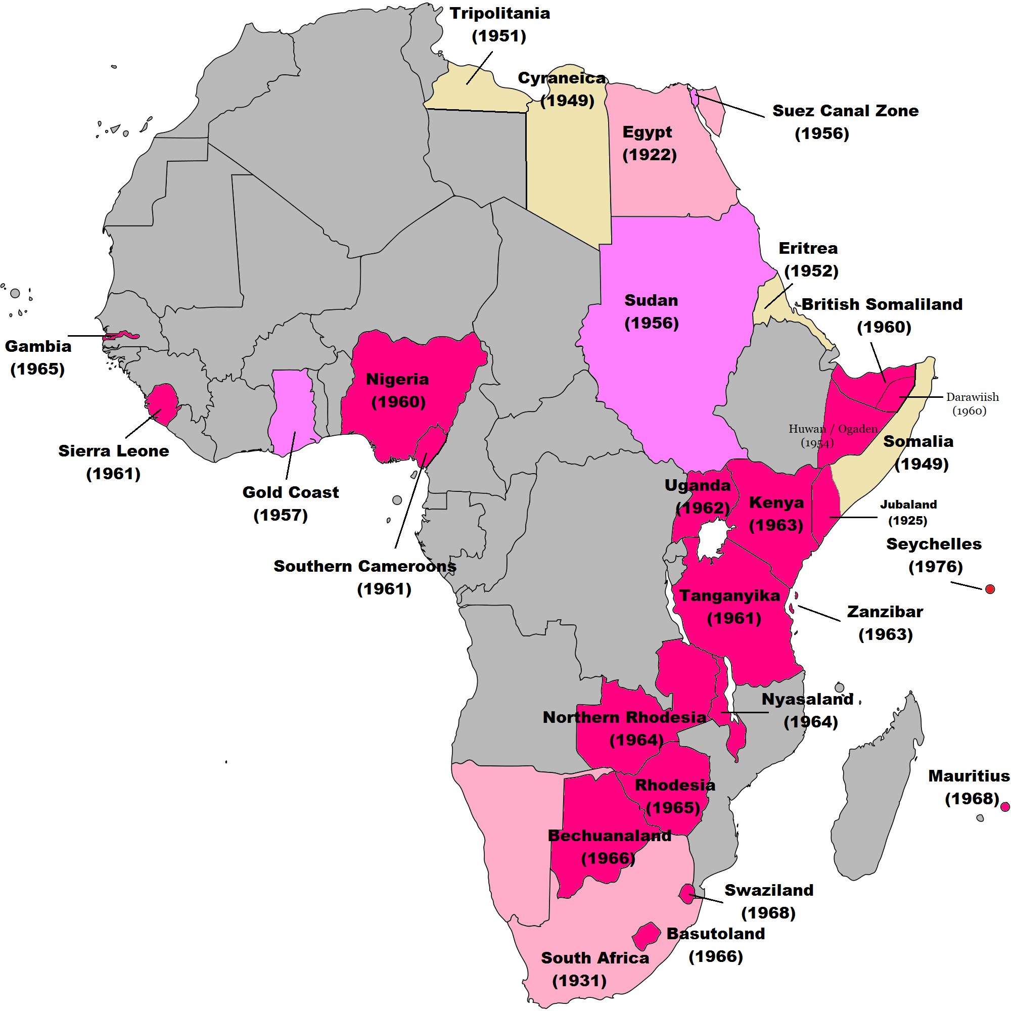
English: Map of British decolonisation in Africa. The beige areas were under British military administration after WW2. The different shades of pink refer to the stages of decolonization according to decades. |
| 日付 | 2008年11月1日 (当初のアップロード日) |
| 原典 |
Transferred from en.wikipedia; transfer was stated to be made by User:Hejsa. Blank map from File:BlankMap-World3.svg . Original text:
|
| 作者 | The Red Hat of Pat Ferrick t (log) |
| 許可 (ファイルの再利用) |
Released into the public domain (by the author). |
ライセンス
| |
このファイルは、ウィキメディア・コモンズ版プロジェクトにおいて、著作者であるThe Red Hat of Pat Ferrickによりその権利が放棄され、パブリックドメインの状態にあります。これは全世界で適用されます。 一部の国では、これが法的に可能ではない場合があります。その場合は、次のように宣言します。 The Red Hat of Pat Ferrickは、あらゆる人に対して、法により必要とされている条件を除き、如何なる条件も課すことなく、その目的を問わずこの著作物を利用する権利を与えます。 |
元のアップロードログ
元のファイルページはこちら。以下の利用者は全てen.wikipediaに属します。
- 2008-11-02 00:56 The Red Hat of Pat Ferrick 757×785× (171674 bytes) {{Information |Description=Map of British decolonisation in Africa. |Source=I created this work entirely by myself. |Date=1 November 2008 |Author=~~~ |other_versions= }}
ファイルの履歴
過去の版のファイルを表示するには、その版の日時をクリックしてください。
| 日付と時刻 | サムネイル | 寸法 | 利用者 | コメント | |
|---|---|---|---|---|---|
| 現在の版 | 2021年11月8日 (月) 08:49 | | 2,000 × 2,000 (406キロバイト) | Randomastwritter | ogaden |
| 2021年10月30日 (土) 03:23 |  | 2,000 × 2,000 (399キロバイト) | Randomastwritter | juba | |
| 2013年12月7日 (土) 01:38 |  | 2,000 × 2,000 (396キロバイト) | Zello | corrected map that better reflects historical realities (for example South-West Africa, Rhodesia), also Mauritius and Seychelle added, and new colour for territories under temporary military administration after WW2 | |
| 2013年11月22日 (金) 18:52 |  | 757 × 785 (159キロバイト) | Zello | Somalia became a UN Trust Territory under Italian administration in 1949. The correction was requested also on the talk page. | |
| 2009年9月13日 (日) 16:08 |  | 757 × 785 (168キロバイト) | Hejsa | {{Information |Description={{en|Map of British decolonisation in Africa.}} |Source=Transferred from [http://en.wikipedia.org en.wikipedia]; transfer was stated to be made by User:Hejsa. |Date=1 November 2008<br/> ({{Date|2008|11|02}} (original upload |
ファイルの使用状況
このファイルを使用しているページはありません。
グローバルなファイル使用状況
以下に挙げる他のウィキがこの画像を使っています:
- ar.wikipedia.org での使用状況
- ast.wikipedia.org での使用状況
- azb.wikipedia.org での使用状況
- az.wikipedia.org での使用状況
- ba.wikipedia.org での使用状況
- cs.wikipedia.org での使用状況
- da.wikipedia.org での使用状況
- de.wikipedia.org での使用状況
- el.wikipedia.org での使用状況
- en.wikipedia.org での使用状況
- British Empire
- History of the United Kingdom
- Zimbabwe
- Harold Macmillan
- Balkanization
- Decolonization
- Cold War (1953–1962)
- Decolonisation of Africa
- List of national border changes (1914–present)
- Contemporary history
- Portal:Modern history
- User:Jr8825/sandbox 3
- User:Guettarda/Sandbox 50
- User:Falcaorib/Africa
- eu.wikipedia.org での使用状況
- fr.wikipedia.org での使用状況
- fr.wikiversity.org での使用状況
- hy.wikipedia.org での使用状況
- id.wikipedia.org での使用状況
- it.wikipedia.org での使用状況
- ka.wikipedia.org での使用状況
- ko.wikipedia.org での使用状況
- lv.wikipedia.org での使用状況
- ms.wikipedia.org での使用状況
- nl.wikipedia.org での使用状況
- no.wikipedia.org での使用状況
- pl.wikipedia.org での使用状況
- pt.wikipedia.org での使用状況
- ru.wikipedia.org での使用状況
- si.wikipedia.org での使用状況
- th.wikipedia.org での使用状況
このファイルのグローバル使用状況を表示する。