
ファイル:AfricaLocation.svg

この SVG ファイルのこの PNG プレビューのサイズ: 463 × 236 ピクセル. その他の解像度: 320 × 163 ピクセル | 640 × 326 ピクセル | 1,024 × 522 ピクセル | 1,280 × 652 ピクセル | 2,560 × 1,305 ピクセル。
元のファイル (SVG ファイル、463 × 236 ピクセル、ファイルサイズ: 290キロバイト)
ウィキメディア・コモンズのファイルページにある説明を、以下に表示します。
|
概要
| 解説 |
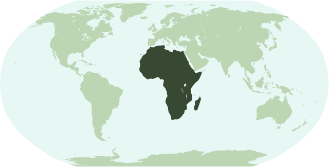
English: Map showing the location of the continent of Africa (including indian ocean islands near Madagascar).
Français : Une carte pour démontrer la location du continent de l'Afrique (avec des îles d'océan indien près de Madagasque).
Interlingua: Un Mapa monstrante le location del continente de Africa (con insulas del oceano indian juxta Madagascar). |
| 日付 | |
| 原典 | 投稿者自身による著作物 |
| 作者 | Notscott |
ライセンス
| この著作物の著作権者である私は、この著作物における権利を放棄しパブリックドメインとします。これは全世界で適用されます。 一部の国では、これが法的に可能ではない場合があります。その場合は、次のように宣言します。 私は、あらゆる人に対して、法により必要とされている条件を除き、如何なる条件も課すことなく、あらゆる目的のためにこの著作物を使用する権利を与えます。 |
ファイルの履歴
過去の版のファイルを表示するには、その版の日時をクリックしてください。
| 日付と時刻 | サムネイル | 寸法 | 利用者 | コメント | |
|---|---|---|---|---|---|
| 現在の版 | 2007年1月15日 (月) 01:23 | | 463 × 236 (290キロバイト) | Notscott | {{en|Map showing the location of the continent of Africa (including indian ocean islands near Madagascar).}} {{fr|Une carte pour démontrer la location du continent de l'Afrique (avec des îles d'océan indien près de Madagasque).}} {{ia|Un Mapa monstran |
| 2007年1月14日 (日) 23:50 |  | 463 × 236 (290キロバイト) | Notscott | {{en|Map showing the location of the continent of Africa (including indian ocean islands near Madagascar).}} {{fr|Une carte pour démontrer la location du continent d'Afrique (avec des îles d'océan indien près de Madagasque).}} {{ia|Un Mapa monstrante |
ファイルの使用状況
このファイルを使用しているページはありません。
グローバルなファイル使用状況
以下に挙げる他のウィキがこの画像を使っています:
- arz.wikipedia.org での使用状況
- جنوب السودان
- ليبيا
- مصر
- جمهورية كونجو الديموقراطيه
- زيمبابوى
- اسواتينى
- سينيجال
- رواندا
- اوجاندا
- ثيويتا
- الجزاير
- سانت هيلينا
- قالب:افريقيا
- قالب:امريكا الجنوبية/شرح
- قالب:شرح استعمال قوالب القارات
- اريتريا
- شمال افريقيا
- شرق افريقيا
- وسط افريقيا
- كوت ديفوار
- جيبوتى
- بوركينا فاسو
- بوتسوانا
- افريقيا الوسطى
- الاحزاب السياسية فى تونس
- الاحزاب السياسية فى جنوب السودان
- الاحزاب السياسية فى السودان
- الاحزاب السياسيه فى المغرب
- جمهورية الكونجو
- جينيا
- جامبيا
- لغات مصر
- قالب:الاحزاب السياسيه فى دول افريقيا
- قالب:اناشيد دول افريقيا الوطنيه
- قالب:جامعات افريقيا
- avk.wikipedia.org での使用状況
- bi.wikipedia.org での使用状況
- bm.wikipedia.org での使用状況
- bpy.wikipedia.org での使用状況
- cbk-zam.wikipedia.org での使用状況
- ch.wikipedia.org での使用状況
- en.wikipedia.org での使用状況
このファイルのグローバル使用状況を表示する。