
ファイル:Wright Brothers Memorial-27527-1.JPG

このプレビューのサイズ: 600 × 600 ピクセル。 その他の解像度: 240 × 240 ピクセル | 480 × 480 ピクセル | 768 × 768 ピクセル | 1,024 × 1,024 ピクセル | 1,600 × 1,600 ピクセル。
元のファイル (1,600 × 1,600 ピクセル、ファイルサイズ: 545キロバイト、MIME タイプ: image/jpeg)
ウィキメディア・コモンズのファイルページにある説明を、以下に表示します。
|
概要
| 解説 |
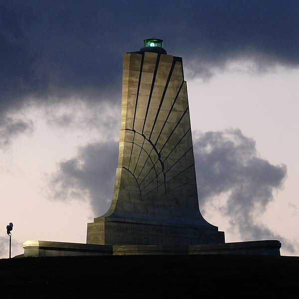
Standing sixty feet (18.3 meters) tall and perched atop a ninety foot (27.4 meters) stabilized sand dune known as Kill Devil Hill, this monument towers over Wright Brothers National Memorial Park in Kill Devil Hills, NC. The park commemorates and preserves the site where the Wright brothers launched the world's first successful sustained, powered flights in a heavier-than-air machine. The inscription that wraps around the base of the monument states "In commemoration of the conquest of the air by the brothers Wilbur and Orville Wright. Conceived by genius, achieved by dauntless resolution and unconquerable faith." Photo taken with a Panasonic Lumix DMC-FZ50 in Dare County, NC, USA. |
| 日付 | 2008年10月19日, 06:56 −04:00 |
| 原典 |
KenThomas.us (personal website of photographer) |
| 作者 | Ken Thomas |
| 許可 (ファイルの再利用) |
This image is released to the public domain, and therefore no permission or credit is required. Comments and/or feedback however, are always welcome. See my user page for contact info. |
| その他のバージョン |
|

ライセンス
| この著作物の著作権者である私は、この著作物における権利を放棄しパブリックドメインとします。これは全世界で適用されます。 一部の国では、これが法的に可能ではない場合があります。その場合は、次のように宣言します。 私は、あらゆる人に対して、法により必要とされている条件を除き、如何なる条件も課すことなく、あらゆる目的のためにこの著作物を使用する権利を与えます。 |
| カメラの位置 | | 以下のサービスでこの位置を確認する: オープンストリートマップ |
|---|
ファイルの履歴
過去の版のファイルを表示するには、その版の日時をクリックしてください。
| 日付と時刻 | サムネイル | 寸法 | 利用者 | コメント | |
|---|---|---|---|---|---|
| 現在の版 | 2008年10月20日 (月) 15:18 | | 1,600 × 1,600 (545キロバイト) | Ken Thomas | {{Information |Description=Standing sixty feet (18.3 meters) tall and perched atop a ninety foot (27.4 meters) stabilized sand dune known as Kill Devil Hill, this monument towers o |
ファイルの使用状況
以下のページがこのファイルを使用しています:
グローバルなファイル使用状況
以下に挙げる他のウィキがこの画像を使っています:
- ast.wikipedia.org での使用状況
- ca.wikipedia.org での使用状況
- ceb.wikipedia.org での使用状況
- cs.wikipedia.org での使用状況
- de.wikipedia.org での使用状況
- en.wikipedia.org での使用状況
- en.wikivoyage.org での使用状況
- eo.wikipedia.org での使用状況
- es.wikipedia.org での使用状況
- fa.wikipedia.org での使用状況
- fi.wikipedia.org での使用状況
- fr.wikipedia.org での使用状況
- hr.wikipedia.org での使用状況
- it.wikipedia.org での使用状況
- nn.wikipedia.org での使用状況
- no.wikipedia.org での使用状況
- pnb.wikipedia.org での使用状況
- pt.wikipedia.org での使用状況
- ru.wikipedia.org での使用状況
- www.wikidata.org での使用状況
- zh.wikipedia.org での使用状況